Mahuixtlan elevation
Mahuixtlan (Veracruz, Coatepec), Mexico elevation is 979 meters and Mahuixtlan elevation in feet is 3212 ft above sea level [src 1]. Mahuixtlan is a populated place (feature code) with elevation that is 335 meters (1099 ft) smaller than average city elevation in Mexico.
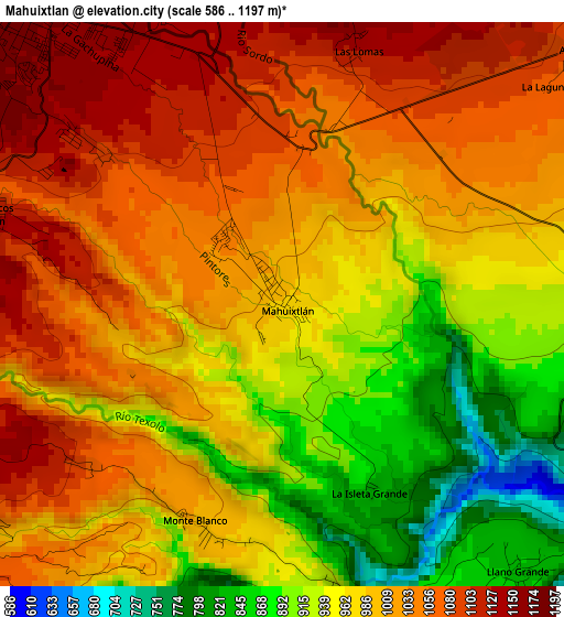
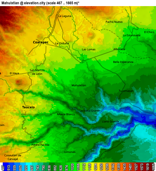
Below is the Elevation map of Mahuixtlan, which displays elevation range with different colors. Scale of the first map is from 586 to 1197 m (1923 to 3927 ft) with average elevation of 993.9 meters (=3261 ft) [note 1]
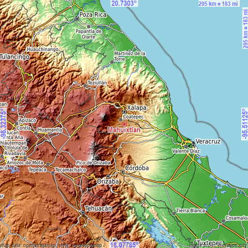
These maps also provides idea of topography and contour of this city, they are displayed at different zoom levels. More info about maps, scale and edge coordinates you can find below images.
| \ | Map #1 | Map #2 | Topo.Map |
| Scale [m] | 586..1197 m | 467..1665 m | × |
| Scale [ft] | 1923..3927 ft | 1532..5463 ft | × |
| Average | 993.9 m = 3261 ft | 1037.2 m = 3403 ft | × |
| Width | 9.22 km = 5.7 mi | 18.43 km = 11.5 mi | 294.9 km = 183.2 mi |
| Height | 9.22 km = 5.7 mi | 18.43 km = 11.5 mi | 294.9 km = 183.2 mi |
| ↑Max Latitude | 19.450923° | 19.492354° | 20.7303° |
| Latitude at center | 19.40948° | 19.40948° | 19.40948° |
| ↓Min Latitude | 19.368027° | 19.326563° | 18.07785° |
| ← Min Longitude | -96.961445° | -97.005391° | -98.32375° |
| Longitude center | -96.9175° | -96.9175° | -96.9175° |
| →Max Longitude | -96.873555° | -96.829609° | -95.51125° |
Nearby cities:
Cities around Mahuixtlan sort by population:
• Coatepec elevation 1202 m
6.6 km,  315°
315°
• Teocelo 1189 m
6.5 km,  245°
245°
• Tuzamapan 874 m
5.7 km,  97°
97°
• San Marcos de León 1097 m
5.2 km,  287°
287°
• Limones 977 m
7.9 km,  184°
184°
• Colonia Úrsulo Galván 1157 m
6.7 km, 288°
• Monte Blanco 997 m
3.8 km,  200°
200°
• Bella Esperanza 1011 m
6 km,  63°
63°
• La Orduña 1149 m
5 km,  337°
337°
• Las Lomas 1134 m
4.4 km,  15°
15°
• Llano Grande 836 m
5.9 km,  137°
137°
• Alborada 1063 m
6.5 km,  48°
48°
Multilingual:
 En español:
Mahuixtlan elevación 979 m.
 En France:
Mahuixtlan élévation 979 m.
 Auf Deutsch:
Mahuixtlan höhe über dem Meeresspiegel ist 979 m.

Sources and notes:
- [note 1] Map square and city borders are not equal. Map elevation data is calculated only from area inside that square.
- [src 1] Elevation data from geonames database provided with same terms of usage.
- [src 2] The elevation map of Mahuixtlan is generated using elevation data from NASA's 3 arcsec (90m) resolution SRTM data.
- [src 3] Base (background) map © OpenStreetMap contributors tiles are generated by Geofabrik and OpenTopoMap.
Copyright & License:
This Mahuixtlan Elevation Map is licensed under CC BY-SA. You may reuse any part from this page, if you give a proper credit by linking to this URL:
 More info on terms of use page.