Coatepec elevation
Coatepec (Veracruz), Mexico elevation is 1202 meters and Coatepec elevation in feet is 3944 ft above sea level [src 1]. Coatepec is a seat of a second-order administrative division (feature code) with elevation that is 112 meters (367 ft) smaller than average city elevation in Mexico.
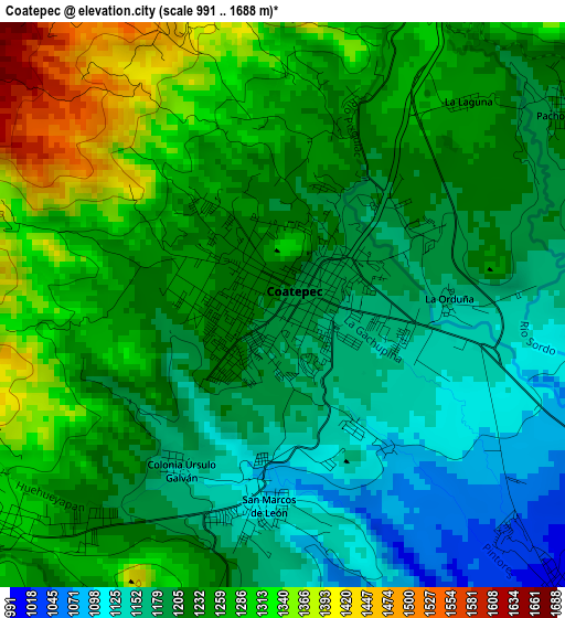
Below is the Elevation map of Coatepec, which displays elevation range with different colors. Scale of the first map is from 991 to 1688 m (3251 to 5538 ft) with average elevation of 1231.1 meters (=4039 ft) [note 1]
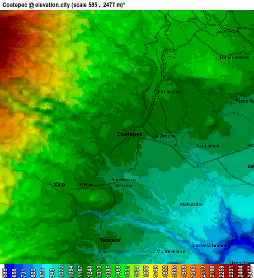
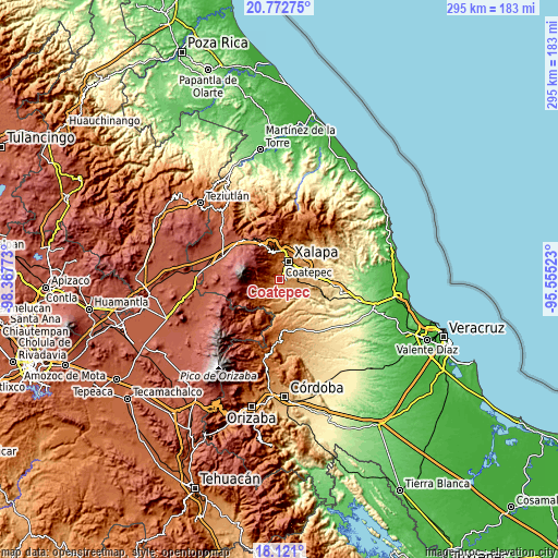
These maps also provides idea of topography and contour of this city, they are displayed at different zoom levels. More info about maps, scale and edge coordinates you can find below images.
| \ | Map #1 | Map #2 | Topo.Map |
| Scale [m] | 991..1688 m | 585..2477 m | × |
| Scale [ft] | 3251..5538 ft | 1919..8127 ft | × |
| Average | 1231.1 m = 4039 ft | 1312.8 m = 4307 ft | × |
| Width | 9.21 km = 5.7 mi | 18.43 km = 11.5 mi | 294.8 km = 183.2 mi |
| Height | 9.21 km = 5.7 mi | 18.43 km = 11.5 mi | 294.9 km = 183.2 mi |
| ↑Max Latitude | 19.493722° | 19.535143° | 20.77275° |
| Latitude at center | 19.45229° | 19.45229° | 19.45229° |
| ↓Min Latitude | 19.410848° | 19.369395° | 18.121° |
| ← Min Longitude | -97.005425° | -97.049371° | -98.36773° |
| Longitude center | -96.96148° | -96.96148° | -96.96148° |
| →Max Longitude | -96.917535° | -96.873589° | -95.55523° |
Nearby cities:
Cities around Coatepec sort by population:
• Xico elevation 1318 m
6 km,  235°
235°
• Teocelo 1189 m
7.5 km,  189°
189°
• San Marcos de León 1097 m
3.2 km, 185°
• Pacho Viejo 1204 m
5.8 km,  54°
54°
• Mahuixtlan 979 m
6.6 km,  135°
135°
• Fraccionamiento las Fuentes 1325 m
9.3 km,  58°
58°
• Pacho Nuevo 1166 m
9.1 km,  72°
72°
• Colonia Úrsulo Galván 1157 m
3.2 km,  214°
214°
• Monte Blanco 997 m
8.9 km,  158°
158°
• La Orduña 1149 m
2.7 km,  92°
92°
• Las Lomas 1134 m
5.8 km,  95°
95°
• La Laguna 1247 m
4.4 km,  41°
41°
Multilingual:
 En español:
Coatepec elevación 1202 m.
 En France:
Coatepec élévation 1202 m.
 Auf Deutsch:
Coatepec höhe über dem Meeresspiegel ist 1202 m.

Sources and notes:
- [note 1] Map square and city borders are not equal. Map elevation data is calculated only from area inside that square.
- [src 1] Elevation data from geonames database provided with same terms of usage.
- [src 2] The elevation map of Coatepec is generated using elevation data from NASA's 3 arcsec (90m) resolution SRTM data.
- [src 3] Base (background) map © OpenStreetMap contributors tiles are generated by Geofabrik and OpenTopoMap.
Copyright & License:
This Coatepec Elevation Map is licensed under CC BY-SA. You may reuse any part from this page, if you give a proper credit by linking to this URL:
 More info on terms of use page.