Tuzamapan elevation
Tuzamapan (Veracruz, Coatepec), Mexico elevation is 874 meters and Tuzamapan elevation in feet is 2867 ft above sea level [src 1]. Tuzamapan is a populated place (feature code) with elevation that is 440 meters (1444 ft) smaller than average city elevation in Mexico.
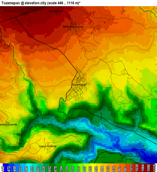
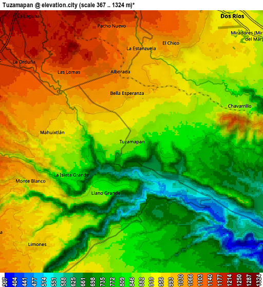
Below is the Elevation map of Tuzamapan, which displays elevation range with different colors. Scale of the first map is from 446 to 1116 m (1463 to 3661 ft) with average elevation of 839 meters (=2753 ft) [note 1]
These maps also provides idea of topography and contour of this city, they are displayed at different zoom levels. More info about maps, scale and edge coordinates you can find below images.
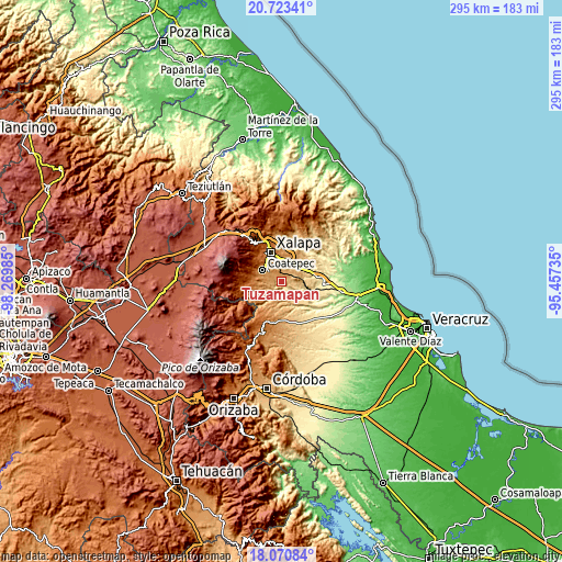
| \ | Map #1 | Map #2 | Topo.Map |
| Scale [m] | 446..1116 m | 367..1324 m | × |
| Scale [ft] | 1463..3661 ft | 1204..4344 ft | × |
| Average | 839 m = 2753 ft | 895.1 m = 2937 ft | × |
| Width | 9.22 km = 5.7 mi | 18.44 km = 11.5 mi | 294.9 km = 183.2 mi |
| Height | 9.22 km = 5.7 mi | 18.44 km = 11.5 mi | 295 km = 183.3 mi |
| ↑Max Latitude | 19.443974° | 19.485408° | 20.72341° |
| Latitude at center | 19.40253° | 19.40253° | 19.40253° |
| ↓Min Latitude | 19.361075° | 19.31961° | 18.07084° |
| ← Min Longitude | -96.907545° | -96.951491° | -98.26985° |
| Longitude center | -96.8636° | -96.8636° | -96.8636° |
| →Max Longitude | -96.819655° | -96.775709° | -95.45735° |
Nearby cities:
Cities around Tuzamapan sort by population:
• Estanzuela elevation 1033 m
6.5 km,  5°
5°
• Mahuixtlan 979 m
5.7 km,  277°
277°
• Pacho Nuevo 1166 m
8.4 km,  349°
349°
• El Chico 1041 m
7.6 km,  22°
22°
• Limones 977 m
9.5 km,  221°
221°
• Monte Blanco 997 m
7.5 km,  248°
248°
• Bella Esperanza 1011 m
3.4 km, 354°
• La Orduña 1149 m
9.3 km,  305°
305°
• Las Lomas 1134 m
6.7 km,  318°
318°
• Chavarrillo 878 m
7.7 km,  70°
70°
• Llano Grande 836 m
4 km,  205°
205°
• Alborada 1063 m
5.2 km, 351°
Multilingual:
 En español:
Tuzamapan elevación 874 m.
 En France:
Tuzamapan élévation 874 m.
 Auf Deutsch:
Tuzamapan höhe über dem Meeresspiegel ist 874 m.

Sources and notes:
- [note 1] Map square and city borders are not equal. Map elevation data is calculated only from area inside that square.
- [src 1] Elevation data from geonames database provided with same terms of usage.
- [src 2] The elevation map of Tuzamapan is generated using elevation data from NASA's 3 arcsec (90m) resolution SRTM data.
- [src 3] Base (background) map © OpenStreetMap contributors tiles are generated by Geofabrik and OpenTopoMap.
Copyright & License:
This Tuzamapan Elevation Map is licensed under CC BY-SA. You may reuse any part from this page, if you give a proper credit by linking to this URL:
 More info on terms of use page.