Estanzuela elevation
Estanzuela (Veracruz, Emiliano Zapata), Mexico elevation is 1033 meters and Estanzuela elevation in feet is 3389 ft above sea level [src 1]. Estanzuela is a populated place (feature code) with elevation that is 281 meters (922 ft) smaller than average city elevation in Mexico.
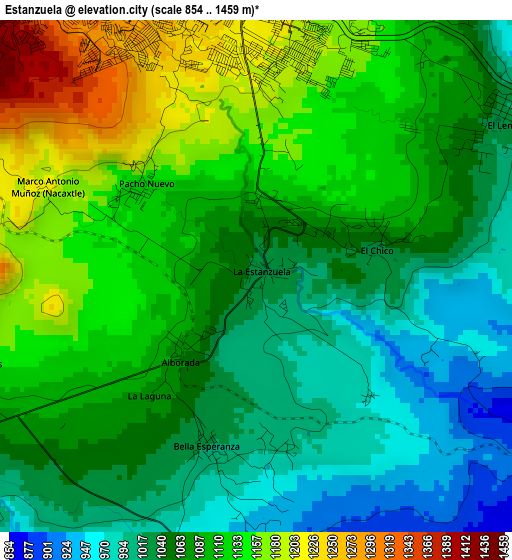
Below is the Elevation map of Estanzuela, which displays elevation range with different colors. Scale of the first map is from 854 to 1459 m (2802 to 4787 ft) with average elevation of 1079.9 meters (=3543 ft) [note 1]
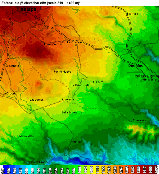
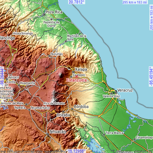
These maps also provides idea of topography and contour of this city, they are displayed at different zoom levels. More info about maps, scale and edge coordinates you can find below images.
| \ | Map #1 | Map #2 | Topo.Map |
| Scale [m] | 854..1459 m | 519..1492 m | × |
| Scale [ft] | 2802..4787 ft | 1703..4895 ft | × |
| Average | 1079.9 m = 3543 ft | 1037.4 m = 3404 ft | × |
| Width | 9.21 km = 5.7 mi | 18.43 km = 11.5 mi | 294.8 km = 183.2 mi |
| Height | 9.21 km = 5.7 mi | 18.43 km = 11.5 mi | 294.9 km = 183.2 mi |
| ↑Max Latitude | 19.502239° | 19.543658° | 20.7812° |
| Latitude at center | 19.46081° | 19.46081° | 19.46081° |
| ↓Min Latitude | 19.41937° | 19.377919° | 18.12958° |
| ← Min Longitude | -96.902135° | -96.946081° | -98.26444° |
| Longitude center | -96.85819° | -96.85819° | -96.85819° |
| →Max Longitude | -96.814245° | -96.770299° | -95.45194° |
Nearby cities:
Cities around Estanzuela sort by population:
• Colonia Santa Bárbara elevation 1277 m
5 km,  335°
335°
• Jacarandas 1198 m
3.9 km,  8°
8°
• Tuzamapan 874 m
6.5 km,  185°
185°
• Lomas Verdes 1315 m
5.8 km,  326°
326°
• Fraccionamiento las Fuentes 1325 m
4.9 km,  323°
323°
• Pacho Nuevo 1166 m
2.8 km,  310°
310°
• El Chico 1041 m
2.3 km,  76°
76°
• El Lencero 1017 m
5.4 km,  54°
54°
• Bella Esperanza 1011 m
3.2 km,  195°
195°
• Las Lomas 1134 m
5.2 km,  253°
253°
• Alborada 1063 m
1.9 km,  224°
224°
• Las Trancas 1218 m
4.9 km,  352°
352°
Multilingual:
 En español:
Estanzuela elevación 1033 m.
 En France:
Estanzuela élévation 1033 m.
 Auf Deutsch:
Estanzuela höhe über dem Meeresspiegel ist 1033 m.

Sources and notes:
- [note 1] Map square and city borders are not equal. Map elevation data is calculated only from area inside that square.
- [src 1] Elevation data from geonames database provided with same terms of usage.
- [src 2] The elevation map of Estanzuela is generated using elevation data from NASA's 3 arcsec (90m) resolution SRTM data.
- [src 3] Base (background) map © OpenStreetMap contributors tiles are generated by Geofabrik and OpenTopoMap.
Copyright & License:
This Estanzuela Elevation Map is licensed under CC BY-SA. You may reuse any part from this page, if you give a proper credit by linking to this URL:
 More info on terms of use page.