Cerro Gordo elevation
Cerro Gordo (Veracruz, Emiliano Zapata), Mexico elevation is 590 meters and Cerro Gordo elevation in feet is 1936 ft above sea level [src 1]. Cerro Gordo is a populated place (feature code) with elevation that is 724 meters (2375 ft) smaller than average city elevation in Mexico.
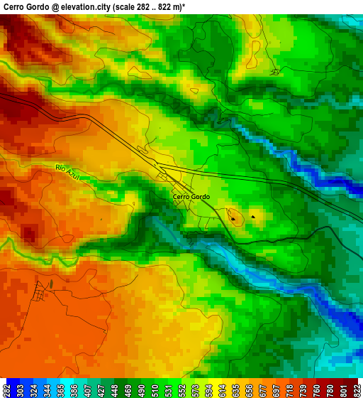
Below is the Elevation map of Cerro Gordo, which displays elevation range with different colors. Scale of the first map is from 282 to 822 m (925 to 2697 ft) with average elevation of 567 meters (=1860 ft) [note 1]
These maps also provides idea of topography and contour of this city, they are displayed at different zoom levels. More info about maps, scale and edge coordinates you can find below images.
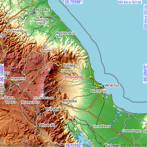
| \ | Map #1 | Topo.Map |
| Scale [m] | 282..822 m | × |
| Scale [ft] | 925..2697 ft | × |
| Average | 567 m = 1860 ft | × |
| Width | 9.22 km = 5.7 mi | 294.9 km = 183.2 mi |
| Height | 9.22 km = 5.7 mi | 294.9 km = 183.2 mi |
| ↑Max Latitude | 19.474796° | 20.75398° |
| Latitude at center | 19.43336° | 19.43336° |
| ↓Min Latitude | 19.391913° | 18.10192° |
| ← Min Longitude | -96.744345° | -98.10665° |
| Longitude center | -96.7004° | -96.7004° |
| →Max Longitude | -96.656455° | -95.29415° |
Nearby cities:
Cities around Cerro Gordo sort by population:
• Villa Emiliano Zapata elevation 422 m
9 km,  150°
150°
• Actopan 254 m
11.8 km,  48°
48°
• Jalcomulco 350 m
13 km,  209°
209°
• Chavarrillo 878 m
9.9 km,  264°
264°
• Chicuasen 350 m
10.9 km,  15°
15°
• Trapiche del Rosario 481 m
12.9 km,  340°
340°
• Palo Gacho 344 m
8.2 km,  125°
125°
• Plan del Río 292 m
6.1 km,  124°
124°
• Dos Ríos 937 m
11.8 km,  298°
298°
• Otates 528 m
9.9 km,  350°
350°
• Rancho Viejo 908 m
8.6 km,  278°
278°
• Apazapan 306 m
12.7 km,  188°
188°
Multilingual:
 En español:
Cerro Gordo elevación 590 m.
 En France:
Cerro Gordo élévation 590 m.
 Auf Deutsch:
Cerro Gordo höhe über dem Meeresspiegel ist 590 m.

Sources and notes:
- [note 1] Map square and city borders are not equal. Map elevation data is calculated only from area inside that square.
- [src 1] Elevation data from geonames database provided with same terms of usage.
- [src 2] The elevation map of Cerro Gordo is generated using elevation data from NASA's 3 arcsec (90m) resolution SRTM data.
- [src 3] Base (background) map © OpenStreetMap contributors tiles are generated by Geofabrik and OpenTopoMap.
Copyright & License:
This Cerro Gordo Elevation Map is licensed under CC BY-SA. You may reuse any part from this page, if you give a proper credit by linking to this URL:
 More info on terms of use page.