Actopan elevation
Actopan (Veracruz), Mexico elevation is 254 meters and Actopan elevation in feet is 833 ft above sea level [src 1]. Actopan is a seat of a second-order administrative division (feature code) with elevation that is 1060 meters (3478 ft) smaller than average city elevation in Mexico.
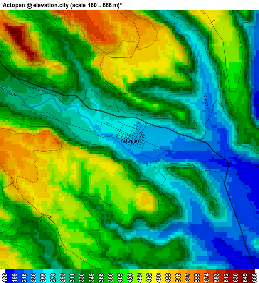
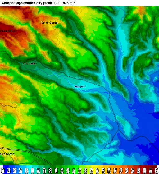
Below is the Elevation map of Actopan, which displays elevation range with different colors. Scale of the first map is from 180 to 668 m (591 to 2192 ft) with average elevation of 360.4 meters (=1182 ft) [note 1]
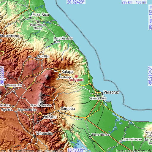
These maps also provides idea of topography and contour of this city, they are displayed at different zoom levels. More info about maps, scale and edge coordinates you can find below images.
| \ | Map #1 | Map #2 | Topo.Map |
| Scale [m] | 180..668 m | 102..923 m | × |
| Scale [ft] | 591..2192 ft | 335..3028 ft | × |
| Average | 360.4 m = 1182 ft | 392.1 m = 1286 ft | × |
| Width | 9.21 km = 5.7 mi | 18.42 km = 11.4 mi | 294.8 km = 183.2 mi |
| Height | 9.21 km = 5.7 mi | 18.42 km = 11.4 mi | 294.8 km = 183.2 mi |
| ↑Max Latitude | 19.545688° | 19.587096° | 20.82429° |
| Latitude at center | 19.50427° | 19.50427° | 19.50427° |
| ↓Min Latitude | 19.462841° | 19.421402° | 18.17339° |
| ← Min Longitude | -96.660625° | -96.704571° | -98.02293° |
| Longitude center | -96.61668° | -96.61668° | -96.61668° |
| →Max Longitude | -96.572735° | -96.528789° | -95.21043° |
Nearby cities:
Cities around Actopan sort by population:
• Mesa de Guadalupe elevation 834 m
10.9 km,  307°
307°
• Mozomboa 74 m
14.6 km,  89°
89°
• Blanca Espuma 686 m
11.4 km,  318°
318°
• Cerro Gordo 590 m
11.8 km,  228°
228°
• Chicuasen 350 m
6.4 km,  294°
294°
• La Reforma 684 m
10.4 km,  350°
350°
• Trapiche del Rosario 481 m
13.7 km, 288°
• Palo Gacho 344 m
12.8 km,  189°
189°
• Plan del Río 292 m
12 km,  198°
198°
• Cerro Gordo 644 m
8 km,  335°
335°
• Los Ídolos 95 m
14.6 km,  134°
134°
• Otates 528 m
10.5 km,  280°
280°
Multilingual:
 En español:
Actopan elevación 254 m.
 En France:
Actopan élévation 254 m.


Sources and notes:
- [note 1] Map square and city borders are not equal. Map elevation data is calculated only from area inside that square.
- [src 1] Elevation data from geonames database provided with same terms of usage.
- [src 2] The elevation map of Actopan is generated using elevation data from NASA's 3 arcsec (90m) resolution SRTM data.
- [src 3] Base (background) map © OpenStreetMap contributors tiles are generated by Geofabrik and OpenTopoMap.
Copyright & License:
This Actopan Elevation Map is licensed under CC BY-SA. You may reuse any part from this page, if you give a proper credit by linking to this URL:
 More info on terms of use page.