Apazapan elevation
Apazapan (Veracruz), Mexico elevation is 306 meters and Apazapan elevation in feet is 1004 ft above sea level [src 1]. Apazapan is a seat of a second-order administrative division (feature code) with elevation that is 1008 meters (3307 ft) smaller than average city elevation in Mexico.
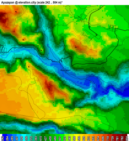
Below is the Elevation map of Apazapan, which displays elevation range with different colors. Scale of the first map is from 242 to 804 m (794 to 2638 ft) with average elevation of 483.8 meters (=1587 ft) [note 1]
These maps also provides idea of topography and contour of this city, they are displayed at different zoom levels. More info about maps, scale and edge coordinates you can find below images.
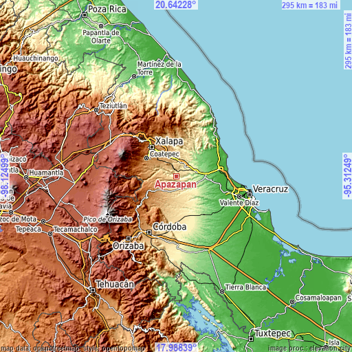
| \ | Map #1 | Topo.Map |
| Scale [m] | 242..804 m | × |
| Scale [ft] | 794..2638 ft | × |
| Average | 483.8 m = 1587 ft | × |
| Width | 9.22 km = 5.7 mi | 295.1 km = 183.4 mi |
| Height | 9.22 km = 5.7 mi | 295.1 km = 183.4 mi |
| ↑Max Latitude | 19.362185° | 20.64228° |
| Latitude at center | 19.32072° | 19.32072° |
| ↓Min Latitude | 19.279244° | 17.98839° |
| ← Min Longitude | -96.762685° | -98.12499° |
| Longitude center | -96.71874° | -96.71874° |
| →Max Longitude | -96.674795° | -95.31249° |
Nearby cities:
Cities around Apazapan sort by population:
• Rinconada elevation 265 m
16.5 km,  76°
76°
• Tuzamapan 874 m
17.7 km,  300°
300°
• Villa Emiliano Zapata 422 m
8 km,  53°
53°
• Jalcomulco 350 m
4.8 km,  285°
285°
• Santa María Tatetla 279 m
5.4 km,  173°
173°
• Mata de Indio 902 m
16.3 km,  231°
231°
• Cerro Gordo 590 m
12.7 km,  8°
8°
• Chavarrillo 878 m
14.1 km,  325°
325°
• Llano Grande 836 m
17.8 km, 288°
• Palo Gacho 344 m
11.6 km, 47°
• Plan del Río 292 m
11.4 km,  37°
37°
• Rancho Viejo 908 m
15.3 km, 334°
Multilingual:
 En español:
Apazapan elevación 306 m.
 En France:
Apazapan élévation 306 m.
 Auf Deutsch:
Apazapan höhe über dem Meeresspiegel ist 306 m.

Sources and notes:
- [note 1] Map square and city borders are not equal. Map elevation data is calculated only from area inside that square.
- [src 1] Elevation data from geonames database provided with same terms of usage.
- [src 2] The elevation map of Apazapan is generated using elevation data from NASA's 3 arcsec (90m) resolution SRTM data.
- [src 3] Base (background) map © OpenStreetMap contributors tiles are generated by Geofabrik and OpenTopoMap.
Copyright & License:
This Apazapan Elevation Map is licensed under CC BY-SA. You may reuse any part from this page, if you give a proper credit by linking to this URL:
 More info on terms of use page.