El Pitahayo elevation
El Pitahayo (Guerrero, Cuajinicuilapa), Mexico elevation is 22 meters and El Pitahayo elevation in feet is 72 ft above sea level [src 1]. El Pitahayo is a populated place (feature code) with elevation that is 1292 meters (4239 ft) smaller than average city elevation in Mexico.
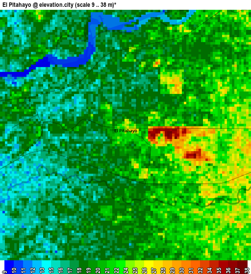
Below is the Elevation map of El Pitahayo, which displays elevation range with different colors. Scale of the first map is from 9 to 38 m (30 to 125 ft) with average elevation of 19.4 meters (=64 ft) [note 1]
These maps also provides idea of topography and contour of this city, they are displayed at different zoom levels. More info about maps, scale and edge coordinates you can find below images.
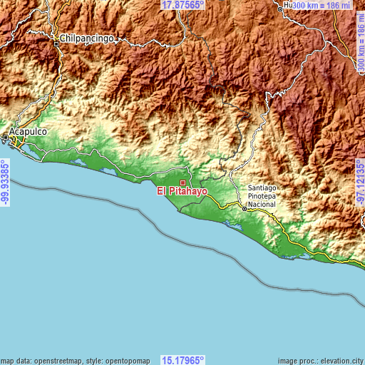
| \ | Map #1 | Topo.Map |
| Scale [m] | 9..38 m | × |
| Scale [ft] | 30..125 ft | × |
| Average | 19.4 m = 64 ft | × |
| Width | 9.37 km = 5.8 mi | 299.8 km = 186.3 mi |
| Height | 9.37 km = 5.8 mi | 299.8 km = 186.3 mi |
| ↑Max Latitude | 16.574484° | 17.87565° |
| Latitude at center | 16.53236° | 16.53236° |
| ↓Min Latitude | 16.490227° | 15.17965° |
| ← Min Longitude | -98.571545° | -99.93385° |
| Longitude center | -98.5276° | -98.5276° |
| →Max Longitude | -98.483655° | -97.12135° |
Nearby cities:
Cities around El Pitahayo sort by population:
• Ometepec elevation 334 m
21.7 km,  36°
36°
• Cuajinicuilapa 51 m
13.8 km,  118°
118°
• Azoyú 369 m
23.7 km,  340°
340°
• Juchitán 123 m
15.7 km,  310°
310°
• San Nicolás 73 m
12.8 km,  175°
175°
• Igualapa 484 m
24.3 km,  12°
12°
• Huehuetán 201 m
12 km, 343°
• San Juan Bautista Lo de Soto 74 m
19.3 km,  96°
96°
• Santiago Tepextla 62 m
23 km,  157°
157°
• Barra de Tecoanapa 6 m
22 km,  263°
263°
• Agua Zarca 168 m
21.2 km,  298°
298°
• Montecillos 103 m
16 km,  168°
168°
Multilingual:
 En español:
El Pitahayo elevación 22 m.
 En France:
El Pitahayo élévation 22 m.
 Auf Deutsch:
El Pitahayo höhe über dem Meeresspiegel ist 22 m.

Sources and notes:
- [note 1] Map square and city borders are not equal. Map elevation data is calculated only from area inside that square.
- [src 1] Elevation data from geonames database provided with same terms of usage.
- [src 2] The elevation map of El Pitahayo is generated using elevation data from NASA's 3 arcsec (90m) resolution SRTM data.
- [src 3] Base (background) map © OpenStreetMap contributors tiles are generated by Geofabrik and OpenTopoMap.
Copyright & License:
This El Pitahayo Elevation Map is licensed under CC BY-SA. You may reuse any part from this page, if you give a proper credit by linking to this URL:
 More info on terms of use page.