Huehuetán elevation
Huehuetán (Guerrero, Azoyú), Mexico elevation is 201 meters and Huehuetán elevation in feet is 659 ft above sea level [src 1]. Huehuetán is a populated place (feature code) with elevation that is 1113 meters (3652 ft) smaller than average city elevation in Mexico.
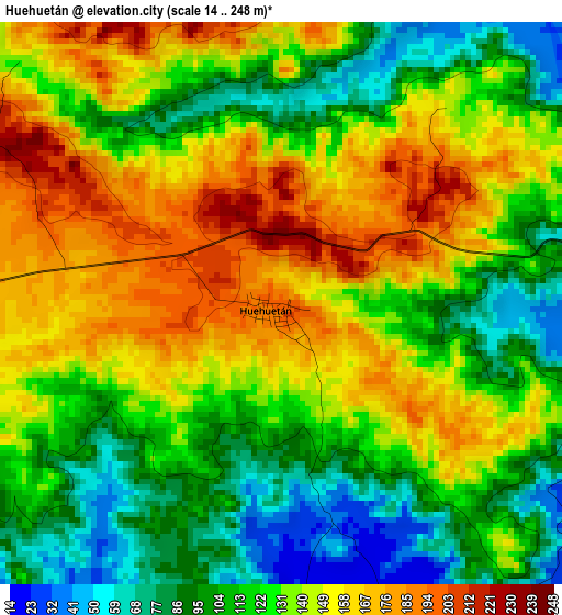
Below is the Elevation map of Huehuetán, which displays elevation range with different colors. Scale of the first map is from 14 to 248 m (46 to 814 ft) with average elevation of 130.5 meters (=428 ft) [note 1]
These maps also provides idea of topography and contour of this city, they are displayed at different zoom levels. More info about maps, scale and edge coordinates you can find below images.
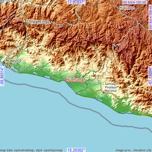
| \ | Map #1 | Topo.Map |
| Scale [m] | 14..248 m | × |
| Scale [ft] | 46..814 ft | × |
| Average | 130.5 m = 428 ft | × |
| Width | 9.36 km = 5.8 mi | 299.6 km = 186.2 mi |
| Height | 9.36 km = 5.8 mi | 299.6 km = 186.2 mi |
| ↑Max Latitude | 16.677931° | 17.97837° |
| Latitude at center | 16.63583° | 16.63583° |
| ↓Min Latitude | 16.593719° | 15.28382° |
| ← Min Longitude | -98.602835° | -99.96514° |
| Longitude center | -98.55889° | -98.55889° |
| →Max Longitude | -98.514945° | -97.15264° |
Nearby cities:
Cities around Huehuetán sort by population:
• Ometepec elevation 334 m
17.2 km,  69°
69°
• Azoyú 369 m
11.7 km,  337°
337°
• Juchitán 123 m
8.8 km,  261°
261°
• Acatepec 628 m
18 km,  51°
51°
• Cuanacaxtitlán 473 m
20.1 km,  334°
334°
• Igualapa 484 m
15 km,  35°
35°
• Quetzalapa 430 m
17.7 km,  19°
19°
• El Pitahayo 22 m
12 km,  163°
163°
• Arcelia de Rodríguez 573 m
14.5 km,  320°
320°
• Chacalapa 538 m
21.8 km,  29°
29°
• Agua Zarca 168 m
15.4 km, 264°
• Zoyatlán 160 m
20.3 km,  293°
293°
Multilingual:
 En español:
Huehuetán elevación 201 m.
 En France:
Huehuetán élévation 201 m.
 Auf Deutsch:
Huehuetán höhe über dem Meeresspiegel ist 201 m.

Sources and notes:
- [note 1] Map square and city borders are not equal. Map elevation data is calculated only from area inside that square.
- [src 1] Elevation data from geonames database provided with same terms of usage.
- [src 2] The elevation map of Huehuetán is generated using elevation data from NASA's 3 arcsec (90m) resolution SRTM data.
- [src 3] Base (background) map © OpenStreetMap contributors tiles are generated by Geofabrik and OpenTopoMap.
Copyright & License:
This Huehuetán Elevation Map is licensed under CC BY-SA. You may reuse any part from this page, if you give a proper credit by linking to this URL:
 More info on terms of use page.