Santiago Tepextla elevation
Santiago Tepextla (Oaxaca, Santiago Tapextla), Mexico elevation is 62 meters and Santiago Tepextla elevation in feet is 203 ft above sea level [src 1]. Santiago Tepextla is a populated place (feature code) with elevation that is 1252 meters (4108 ft) smaller than average city elevation in Mexico.
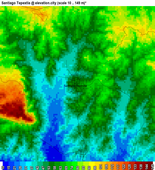
Below is the Elevation map of Santiago Tepextla, which displays elevation range with different colors. Scale of the first map is from 10 to 149 m (33 to 489 ft) with average elevation of 59.6 meters (=196 ft) [note 1]
These maps also provides idea of topography and contour of this city, they are displayed at different zoom levels. More info about maps, scale and edge coordinates you can find below images.
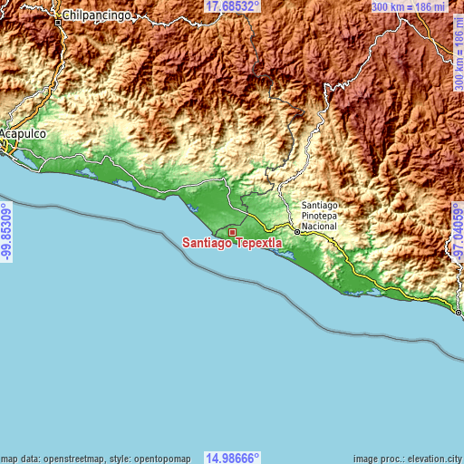
| \ | Map #1 | Topo.Map |
| Scale [m] | 10..149 m | × |
| Scale [ft] | 33..489 ft | × |
| Average | 59.6 m = 196 ft | × |
| Width | 9.38 km = 5.8 mi | 300.1 km = 186.5 mi |
| Height | 9.38 km = 5.8 mi | 300.1 km = 186.5 mi |
| ↑Max Latitude | 16.382816° | 17.68532° |
| Latitude at center | 16.34065° | 16.34065° |
| ↓Min Latitude | 16.298475° | 14.98666° |
| ← Min Longitude | -98.490785° | -99.85309° |
| Longitude center | -98.44684° | -98.44684° |
| →Max Longitude | -98.402895° | -97.04059° |
Nearby cities:
Cities around Santiago Tepextla sort by population:
• Cuajinicuilapa elevation 51 m
15.2 km,  13°
13°
• San Nicolás 73 m
11.5 km,  317°
317°
• Santo Domingo Armenta 57 m
7.4 km,  97°
97°
• El Ciruelo 45 m
20.4 km, 97°
• Huehuetán 201 m
34.9 km,  339°
339°
• San Juan Bautista Lo de Soto 74 m
21.8 km,  29°
29°
• Santiago Llano Grande 77 m
23.5 km,  45°
45°
• Corralero 6 m
29.7 km,  112°
112°
• El Pitahayo 22 m
23 km, 337°
• Santa María Cortijo 82 m
21.2 km, 54°
• Montecillos 103 m
7.8 km, 315°
• San José Estancia Grande 75 m
21.1 km,  82°
82°
Multilingual:
 En español:
Santiago Tepextla elevación 62 m.
 En France:
Santiago Tepextla élévation 62 m.
 Auf Deutsch:
Santiago Tepextla höhe über dem Meeresspiegel ist 62 m.

Sources and notes:
- [note 1] Map square and city borders are not equal. Map elevation data is calculated only from area inside that square.
- [src 1] Elevation data from geonames database provided with same terms of usage.
- [src 2] The elevation map of Santiago Tepextla is generated using elevation data from NASA's 3 arcsec (90m) resolution SRTM data.
- [src 3] Base (background) map © OpenStreetMap contributors tiles are generated by Geofabrik and OpenTopoMap.
Copyright & License:
This Santiago Tepextla Elevation Map is licensed under CC BY-SA. You may reuse any part from this page, if you give a proper credit by linking to this URL:
 More info on terms of use page.