Paso Carretas elevation
Paso Carretas (Puebla, Atzitzintla), Mexico elevation is 2738 meters and Paso Carretas elevation in feet is 8983 ft above sea level [src 1]. Paso Carretas is a populated place (feature code) with elevation that is 1424 meters (4672 ft) bigger than average city elevation in Mexico.
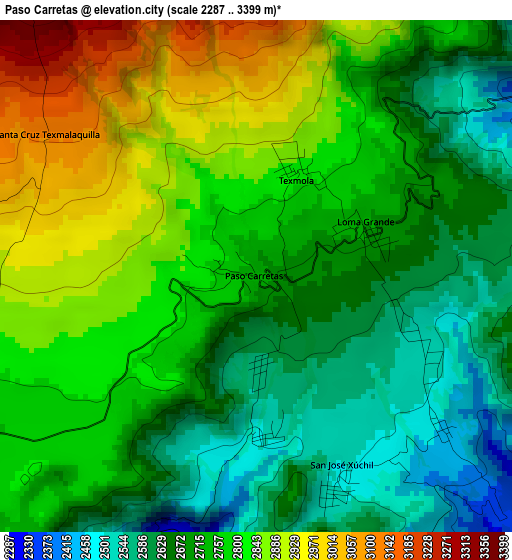
Below is the Elevation map of Paso Carretas, which displays elevation range with different colors. Scale of the first map is from 2287 to 3399 m (7503 to 11152 ft) with average elevation of 2744.6 meters (=9005 ft) [note 1]
These maps also provides idea of topography and contour of this city, they are displayed at different zoom levels. More info about maps, scale and edge coordinates you can find below images.
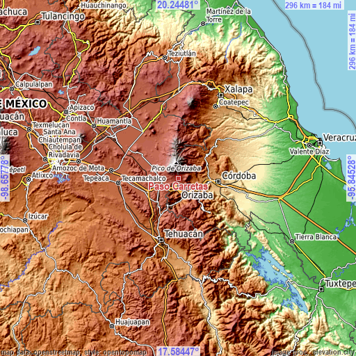
| \ | Map #1 | Topo.Map |
| Scale [m] | 2287..3399 m | × |
| Scale [ft] | 7503..11152 ft | × |
| Average | 2744.6 m = 9005 ft | × |
| Width | 9.24 km = 5.7 mi | 295.8 km = 183.8 mi |
| Height | 9.24 km = 5.7 mi | 295.8 km = 183.8 mi |
| ↑Max Latitude | 18.961496° | 20.24481° |
| Latitude at center | 18.91993° | 18.91993° |
| ↓Min Latitude | 18.878354° | 17.58447° |
| ← Min Longitude | -97.295475° | -98.65778° |
| Longitude center | -97.25153° | -97.25153° |
| →Max Longitude | -97.207585° | -95.84528° |
Nearby cities:
Cities around Paso Carretas sort by population:
• Maltrata elevation 1720 m
12.4 km,  191°
191°
• Ixhuatlancillo 1439 m
11.1 km,  102°
102°
• La Perla 1624 m
12.4 km,  85°
85°
• Atzitzintla 2693 m
8 km,  253°
253°
• Loma Grande 2666 m
2.2 km,  82°
82°
• Cecilio Terán 1486 m
12 km,  166°
166°
• San José Súchil 2492 m
3.9 km,  157°
157°
• Texmola 2850 m
2.3 km,  20°
20°
• Chilapa 2245 m
12.8 km,  53°
53°
• San Isidro el Berro 2594 m
4.9 km, 80°
• Santa Cruz Texmalaquilla 3119 m
4.6 km,  304°
304°
• San José Cuyachapa 2625 m
9.8 km,  222°
222°
Multilingual:
 En español:
Paso Carretas elevación 2738 m.
 En France:
Paso Carretas élévation 2738 m.
 Auf Deutsch:
Paso Carretas höhe über dem Meeresspiegel ist 2738 m.

Sources and notes:
- [note 1] Map square and city borders are not equal. Map elevation data is calculated only from area inside that square.
- [src 1] Elevation data from geonames database provided with same terms of usage.
- [src 2] The elevation map of Paso Carretas is generated using elevation data from NASA's 3 arcsec (90m) resolution SRTM data.
- [src 3] Base (background) map © OpenStreetMap contributors tiles are generated by Geofabrik and OpenTopoMap.
Copyright & License:
This Paso Carretas Elevation Map is licensed under CC BY-SA. You may reuse any part from this page, if you give a proper credit by linking to this URL:
 More info on terms of use page.