Las Lajas elevation
Las Lajas (Puebla, Zacatlán), Mexico elevation is 2546 meters and Las Lajas elevation in feet is 8353 ft above sea level [src 1]. Las Lajas is a populated place (feature code) with elevation that is 1232 meters (4042 ft) bigger than average city elevation in Mexico.
Below is the Elevation map of Las Lajas, which displays elevation range with different colors. Scale of the first map is from 2252 to 2759 m (7388 to 9052 ft) with average elevation of 2507.7 meters (=8227 ft) [note 1]
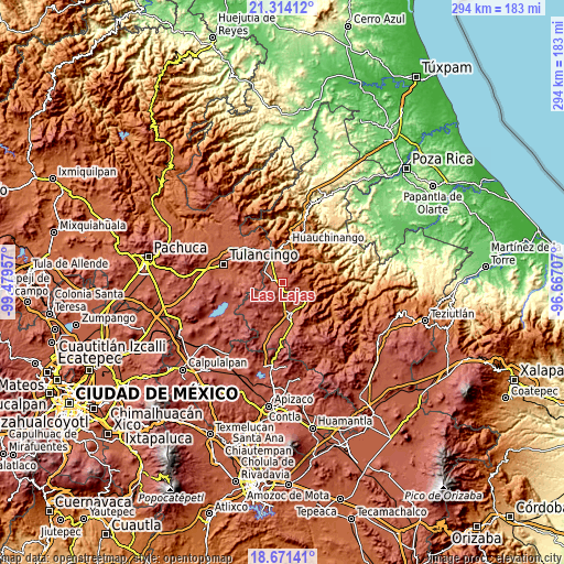
These maps also provides idea of topography and contour of this city, they are displayed at different zoom levels. More info about maps, scale and edge coordinates you can find below images.
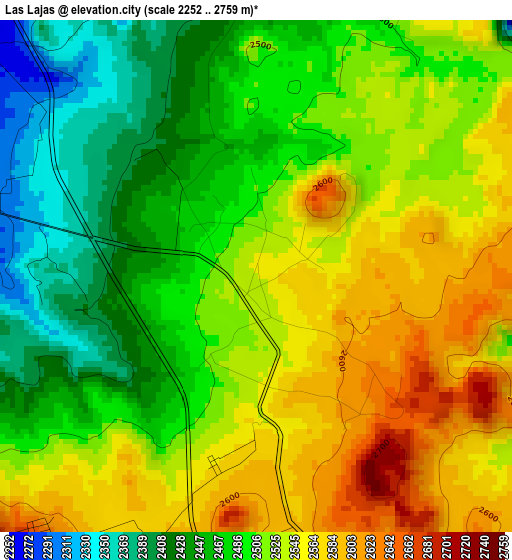
| \ | Map #1 | Topo.Map |
| Scale [m] | 2252..2759 m | × |
| Scale [ft] | 7388..9052 ft | × |
| Average | 2507.7 m = 8227 ft | × |
| Width | 9.18 km = 5.7 mi | 293.8 km = 182.6 mi |
| Height | 9.18 km = 5.7 mi | 293.9 km = 182.6 mi |
| ↑Max Latitude | 20.0396° | 21.31412° |
| Latitude at center | 19.99831° | 19.99831° |
| ↓Min Latitude | 19.957009° | 18.67141° |
| ← Min Longitude | -98.117265° | -99.47957° |
| Longitude center | -98.07332° | -98.07332° |
| →Max Longitude | -98.029375° | -96.66707° |
Nearby cities:
Cities around Las Lajas sort by population:
• Zacatlán elevation 2048 m
13.6 km,  120°
120°
• Atzingo (La Cumbre) 2154 m
11.1 km,  100°
100°
• Jicolapa 2120 m
11 km,  109°
109°
• Camotepec 2478 m
5.5 km,  5°
5°
• Ahuazotepec 2294 m
10.8 km,  299°
299°
• Beristain 2190 m
12.4 km,  329°
329°
• Xoxonacatla 2009 m
13.9 km,  85°
85°
• San Pedro Atmatla 2109 m
14.7 km,  131°
131°
• Tlaxco (Santiago Tlaxco) 1419 m
13.3 km,  60°
60°
• Zempoala 1486 m
12.6 km,  38°
38°
• Venta Grande 2128 m
13.7 km,  348°
348°
• Tepexco 1927 m
12.5 km,  74°
74°
Multilingual:
 En español:
Segunda Sección elevación 2546 m.
 En France:
Las Lajas élévation 2546 m.
 Auf Deutsch:
Las Lajas höhe über dem Meeresspiegel ist 2546 m.

Sources and notes:
- [note 1] Map square and city borders are not equal. Map elevation data is calculated only from area inside that square.
- [src 1] Elevation data from geonames database provided with same terms of usage.
- [src 2] The elevation map of Las Lajas is generated using elevation data from NASA's 3 arcsec (90m) resolution SRTM data.
- [src 3] Base (background) map © OpenStreetMap contributors tiles are generated by Geofabrik and OpenTopoMap.
Copyright & License:
This Las Lajas Elevation Map is licensed under CC BY-SA. You may reuse any part from this page, if you give a proper credit by linking to this URL:
 More info on terms of use page.