Zacatlán elevation
Zacatlán (Puebla), Mexico elevation is 2048 meters and Zacatlán elevation in feet is 6719 ft above sea level [src 1]. Zacatlán is a seat of a second-order administrative division (feature code) with elevation that is 734 meters (2408 ft) bigger than average city elevation in Mexico.
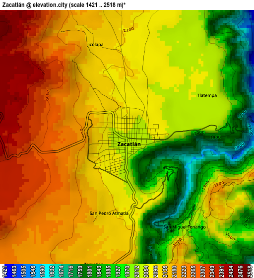
Below is the Elevation map of Zacatlán, which displays elevation range with different colors. Scale of the first map is from 1421 to 2518 m (4662 to 8261 ft) with average elevation of 2083 meters (=6834 ft) [note 1]
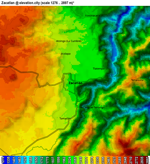
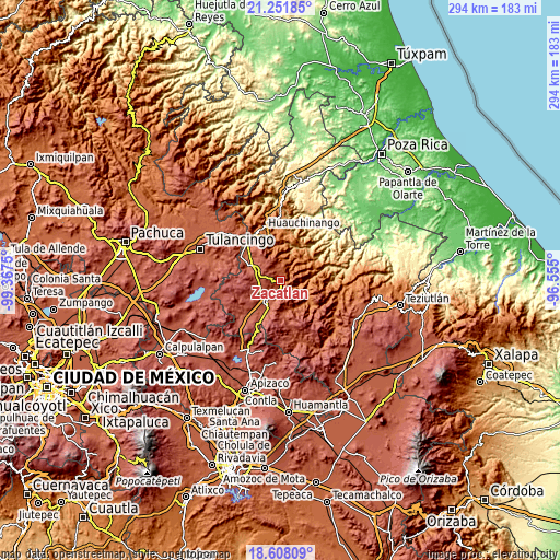
These maps also provides idea of topography and contour of this city, they are displayed at different zoom levels. More info about maps, scale and edge coordinates you can find below images.
| \ | Map #1 | Map #2 | Topo.Map |
| Scale [m] | 1421..2518 m | 1276..2897 m | × |
| Scale [ft] | 4662..8261 ft | 4186..9505 ft | × |
| Average | 2083 m = 6834 ft | 2152.8 m = 7063 ft | × |
| Width | 9.19 km = 5.7 mi | 18.37 km = 11.4 mi | 294 km = 182.7 mi |
| Height | 9.19 km = 5.7 mi | 18.37 km = 11.4 mi | 294 km = 182.7 mi |
| ↑Max Latitude | 19.976807° | 20.018102° | 21.25185° |
| Latitude at center | 19.9355° | 19.9355° | 19.9355° |
| ↓Min Latitude | 19.894183° | 19.852854° | 18.60809° |
| ← Min Longitude | -98.005195° | -98.049141° | -99.3675° |
| Longitude center | -97.96125° | -97.96125° | -97.96125° |
| →Max Longitude | -97.917305° | -97.873359° | -96.555° |
Nearby cities:
Cities around Zacatlán sort by population:
• Atzingo (La Cumbre) elevation 2154 m
5 km,  351°
351°
• Jicolapa 2120 m
3.6 km,  339°
339°
• Ixtlahuaca Barrio 2272 m
12.1 km,  207°
207°
• Tlatempa 2050 m
2.9 km,  69°
69°
• Xoxonacatla 2009 m
8.3 km,  15°
15°
• Tomatlán 2155 m
4.8 km,  195°
195°
• San Pedro Atmatla 2109 m
2.8 km,  193°
193°
• San Jerónimo Coaltepec 1333 m
12.5 km,  52°
52°
• Jilotzingo 1672 m
12.4 km,  29°
29°
• Xochitlaxco (San Baltazar) 1951 m
10.2 km,  86°
86°
• San Miguel Tenango 2062 m
4.1 km,  137°
137°
• Tepexco 1927 m
10.4 km,  1°
1°
Multilingual:
 En español:
Zacatlán elevación 2048 m.
 En France:
Zacatlán élévation 2048 m.
 Auf Deutsch:
Zacatlán höhe über dem Meeresspiegel ist 2048 m.

Sources and notes:
- [note 1] Map square and city borders are not equal. Map elevation data is calculated only from area inside that square.
- [src 1] Elevation data from geonames database provided with same terms of usage.
- [src 2] The elevation map of Zacatlán is generated using elevation data from NASA's 3 arcsec (90m) resolution SRTM data.
- [src 3] Base (background) map © OpenStreetMap contributors tiles are generated by Geofabrik and OpenTopoMap.
Copyright & License:
This Zacatlán Elevation Map is licensed under CC BY-SA. You may reuse any part from this page, if you give a proper credit by linking to this URL:
 More info on terms of use page.