Xochitlaxco (San Baltazar) elevation
Xochitlaxco (San Baltazar) (Puebla, Tepetzintla), Mexico elevation is 1951 meters and Xochitlaxco (San Baltazar) elevation in feet is 6401 ft above sea level [src 1]. Xochitlaxco (San Baltazar) is a populated place (feature code) with elevation that is 637 meters (2090 ft) bigger than average city elevation in Mexico.
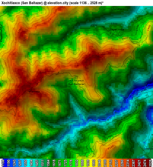
Below is the Elevation map of Xochitlaxco (San Baltazar), which displays elevation range with different colors. Scale of the first map is from 1136 to 2528 m (3727 to 8294 ft) with average elevation of 1814.1 meters (=5952 ft) [note 1]
These maps also provides idea of topography and contour of this city, they are displayed at different zoom levels. More info about maps, scale and edge coordinates you can find below images.
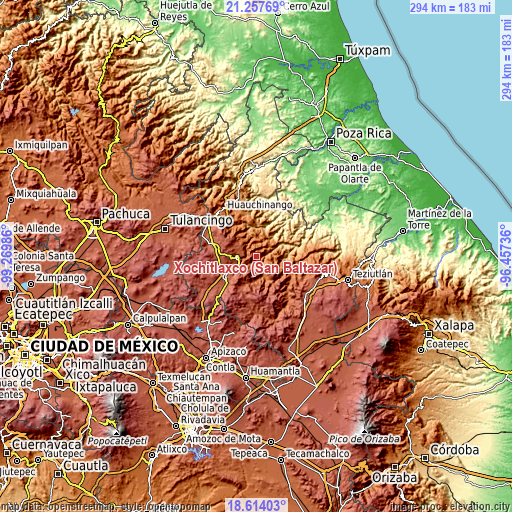
| \ | Map #1 | Topo.Map |
| Scale [m] | 1136..2528 m | × |
| Scale [ft] | 3727..8294 ft | × |
| Average | 1814.1 m = 5952 ft | × |
| Width | 9.19 km = 5.7 mi | 293.9 km = 182.6 mi |
| Height | 9.19 km = 5.7 mi | 294 km = 182.7 mi |
| ↑Max Latitude | 19.982695° | 21.25769° |
| Latitude at center | 19.94139° | 19.94139° |
| ↓Min Latitude | 19.900074° | 18.61403° |
| ← Min Longitude | -97.907555° | -99.26986° |
| Longitude center | -97.86361° | -97.86361° |
| →Max Longitude | -97.819665° | -96.45736° |
Nearby cities:
Cities around Xochitlaxco (San Baltazar) sort by population:
• Tepango elevation 1531 m
9.8 km,  45°
45°
• Tlatempa 2050 m
7.5 km,  272°
272°
• Tlamanca de Hernández 1413 m
5.3 km,  72°
72°
• San Jerónimo Coaltepec 1333 m
7 km,  357°
357°
• Tonalixco 1654 m
5.1 km,  29°
29°
• San Miguel Tenango 2062 m
8.3 km,  243°
243°
• Tepetzintla 1688 m
3.7 km,  38°
38°
• Pochálcatl 1391 m
6.9 km,  8°
8°
• Ahuacatlán 1311 m
7.2 km,  3°
3°
• San Marcos Eloxochitlán 1555 m
9.4 km,  354°
354°
• Cuautempan 1513 m
7.8 km,  113°
113°
• Ixtolco de Morelos 1559 m
6.2 km,  129°
129°
Multilingual:
 En español:
Xochitlaxco (San Baltazar) elevación 1951 m.
 En France:
Xochitlaxco (San Baltazar) élévation 1951 m.
 Auf Deutsch:
Xochitlaxco (San Baltazar) höhe über dem Meeresspiegel ist 1951 m.
 На русском:
Xochitlaxco (San Baltazar) высота над уровнем моря 1951 м
Sources and notes:
- [note 1] Map square and city borders are not equal. Map elevation data is calculated only from area inside that square.
- [src 1] Elevation data from geonames database provided with same terms of usage.
- [src 2] The elevation map of Xochitlaxco (San Baltazar) is generated using elevation data from NASA's 3 arcsec (90m) resolution SRTM data.
- [src 3] Base (background) map © OpenStreetMap contributors tiles are generated by Geofabrik and OpenTopoMap.
Copyright & License:
This Xochitlaxco (San Baltazar) Elevation Map is licensed under CC BY-SA. You may reuse any part from this page, if you give a proper credit by linking to this URL:
 More info on terms of use page.