Ahuacatlán elevation
Ahuacatlán (Puebla), Mexico elevation is 1311 meters and Ahuacatlán elevation in feet is 4301 ft above sea level [src 1]. Ahuacatlán is a populated place (feature code) with elevation that is 3 meters (10 ft) smaller than average city elevation in Mexico.
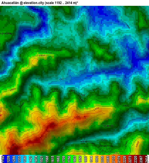
Below is the Elevation map of Ahuacatlán, which displays elevation range with different colors. Scale of the first map is from 1192 to 2414 m (3911 to 7920 ft) with average elevation of 1603.1 meters (=5260 ft) [note 1]
These maps also provides idea of topography and contour of this city, they are displayed at different zoom levels. More info about maps, scale and edge coordinates you can find below images.
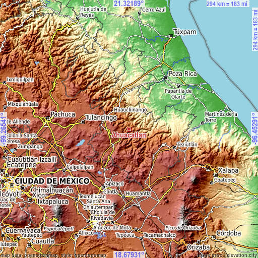
| \ | Map #1 | Topo.Map |
| Scale [m] | 1192..2414 m | × |
| Scale [ft] | 3911..7920 ft | × |
| Average | 1603.1 m = 5260 ft | × |
| Width | 9.18 km = 5.7 mi | 293.8 km = 182.6 mi |
| Height | 9.18 km = 5.7 mi | 293.8 km = 182.6 mi |
| ↑Max Latitude | 20.047438° | 21.32189° |
| Latitude at center | 20.00615° | 20.00615° |
| ↓Min Latitude | 19.964851° | 18.67931° |
| ← Min Longitude | -97.903105° | -99.26541° |
| Longitude center | -97.85916° | -97.85916° |
| →Max Longitude | -97.815215° | -96.45291° |
Nearby cities:
Cities around Ahuacatlán sort by population:
• Tepango elevation 1531 m
6.6 km,  92°
92°
• Tlacotepec (San Mateo) 1306 m
6.1 km,  9°
9°
• Tlamanca de Hernández 1413 m
7.2 km,  140°
140°
• Xochicuautla 1521 m
6.2 km,  329°
329°
• San Jerónimo Coaltepec 1333 m
0.8 km,  251°
251°
• Jilotzingo 1672 m
5.4 km,  302°
302°
• Xochitlaxco (San Baltazar) 1951 m
7.2 km,  183°
183°
• Tlayehualancingo 1449 m
4.5 km,  48°
48°
• Tonalixco 1654 m
3.5 km, 143°
• Tepetzintla 1688 m
4.7 km,  156°
156°
• Pochálcatl 1391 m
0.6 km,  123°
123°
• San Marcos Eloxochitlán 1555 m
2.5 km, 327°
Multilingual:
 En español:
Ahuacatlán elevación 1311 m.
 En France:
Ahuacatlán élévation 1311 m.
 Auf Deutsch:
Ahuacatlán höhe über dem Meeresspiegel ist 1311 m.

Sources and notes:
- [note 1] Map square and city borders are not equal. Map elevation data is calculated only from area inside that square.
- [src 1] Elevation data from geonames database provided with same terms of usage.
- [src 2] The elevation map of Ahuacatlán is generated using elevation data from NASA's 3 arcsec (90m) resolution SRTM data.
- [src 3] Base (background) map © OpenStreetMap contributors tiles are generated by Geofabrik and OpenTopoMap.
Copyright & License:
This Ahuacatlán Elevation Map is licensed under CC BY-SA. You may reuse any part from this page, if you give a proper credit by linking to this URL:
 More info on terms of use page.