Zempoala elevation
Zempoala (Puebla, Chiconcuautla), Mexico elevation is 1486 meters and Zempoala elevation in feet is 4875 ft above sea level [src 1]. Zempoala is a populated place (feature code) with elevation that is 172 meters (564 ft) bigger than average city elevation in Mexico.
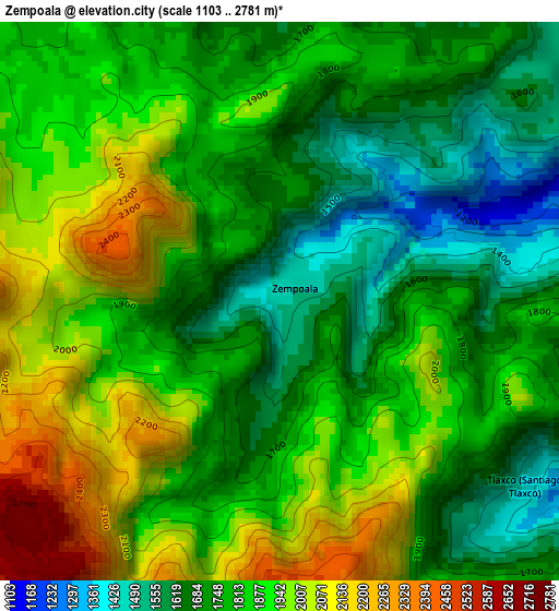
Below is the Elevation map of Zempoala, which displays elevation range with different colors. Scale of the first map is from 1103 to 2781 m (3619 to 9124 ft) with average elevation of 1824.8 meters (=5987 ft) [note 1]
These maps also provides idea of topography and contour of this city, they are displayed at different zoom levels. More info about maps, scale and edge coordinates you can find below images.
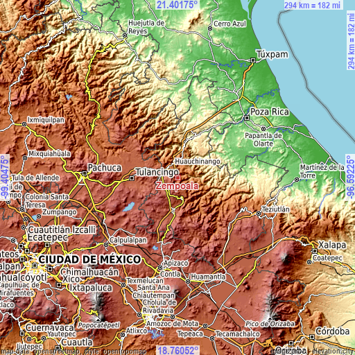
| \ | Map #1 | Topo.Map |
| Scale [m] | 1103..2781 m | × |
| Scale [ft] | 3619..9124 ft | × |
| Average | 1824.8 m = 5987 ft | × |
| Width | 9.18 km = 5.7 mi | 293.7 km = 182.5 mi |
| Height | 9.18 km = 5.7 mi | 293.7 km = 182.5 mi |
| ↑Max Latitude | 20.127967° | 21.40175° |
| Latitude at center | 20.0867° | 20.0867° |
| ↓Min Latitude | 20.045422° | 18.76052° |
| ← Min Longitude | -98.042445° | -99.40475° |
| Longitude center | -97.9985° | -97.9985° |
| →Max Longitude | -97.954555° | -96.59225° |
Nearby cities:
Cities around Zempoala sort by population:
• Chiconcuautla elevation 1507 m
6.3 km,  81°
81°
• Chicahuaxtla 1207 m
8.3 km,  41°
41°
• Xaltepec 1349 m
8.7 km,  358°
358°
• Camotepec 2478 m
8.5 km,  238°
238°
• San Lorenzo Tlaxipehuala 1721 m
5.5 km,  28°
28°
• Ahuacatlán 1704 m
5.7 km,  350°
350°
• Tlaxco (Santiago Tlaxco) 1419 m
4.9 km,  130°
130°
• Toxtla 1393 m
5.8 km,  113°
113°
• Tlaola 1169 m
9.8 km,  53°
53°
• Xilocuautla 1639 m
6.4 km,  336°
336°
• Tepexco 1927 m
7.7 km,  146°
146°
• San Cristóbal Xochimilpa 1084 m
9.8 km,  103°
103°
Multilingual:
 En español:
Zempoala elevación 1486 m.
 En France:
Zempoala élévation 1486 m.
 Auf Deutsch:
Zempoala höhe über dem Meeresspiegel ist 1486 m.

Sources and notes:
- [note 1] Map square and city borders are not equal. Map elevation data is calculated only from area inside that square.
- [src 1] Elevation data from geonames database provided with same terms of usage.
- [src 2] The elevation map of Zempoala is generated using elevation data from NASA's 3 arcsec (90m) resolution SRTM data.
- [src 3] Base (background) map © OpenStreetMap contributors tiles are generated by Geofabrik and OpenTopoMap.
Copyright & License:
This Zempoala Elevation Map is licensed under CC BY-SA. You may reuse any part from this page, if you give a proper credit by linking to this URL:
 More info on terms of use page.