Xalacapan de Lucke elevation
Xalacapan de Lucke (Puebla, Zacapoaxtla), Mexico elevation is 1631 meters and Xalacapan de Lucke elevation in feet is 5351 ft above sea level [src 1]. Xalacapan de Lucke is a populated place (feature code) with elevation that is 317 meters (1040 ft) bigger than average city elevation in Mexico.
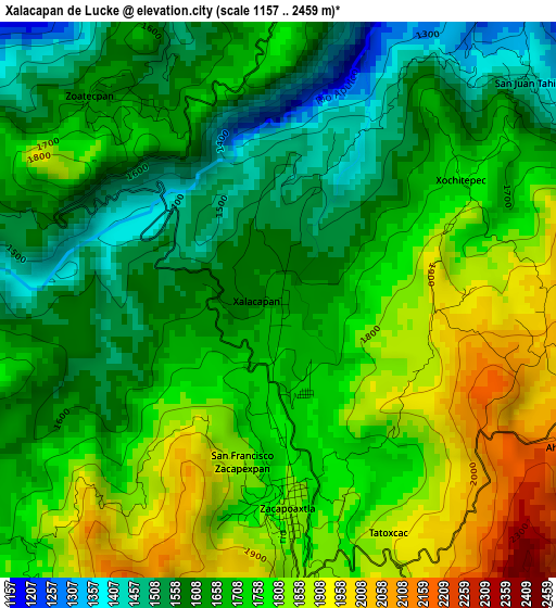
Below is the Elevation map of Xalacapan de Lucke, which displays elevation range with different colors. Scale of the first map is from 1157 to 2459 m (3796 to 8068 ft) with average elevation of 1706.1 meters (=5597 ft) [note 1]
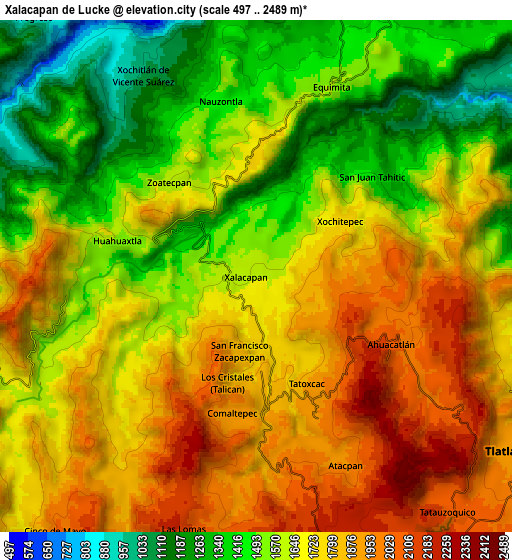
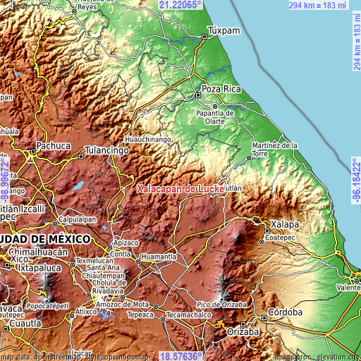
These maps also provides idea of topography and contour of this city, they are displayed at different zoom levels. More info about maps, scale and edge coordinates you can find below images.
| \ | Map #1 | Map #2 | Topo.Map |
| Scale [m] | 1157..2459 m | 497..2489 m | × |
| Scale [ft] | 3796..8068 ft | 1631..8166 ft | × |
| Average | 1706.1 m = 5597 ft | 1665.2 m = 5463 ft | × |
| Width | 9.19 km = 5.7 mi | 18.38 km = 11.4 mi | 294 km = 182.7 mi |
| Height | 9.19 km = 5.7 mi | 18.38 km = 11.4 mi | 294 km = 182.7 mi |
| ↑Max Latitude | 19.945345° | 19.986649° | 21.22065° |
| Latitude at center | 19.90403° | 19.90403° | 19.90403° |
| ↓Min Latitude | 19.862704° | 19.821368° | 18.57636° |
| ← Min Longitude | -97.634415° | -97.678361° | -98.99672° |
| Longitude center | -97.59047° | -97.59047° | -97.59047° |
| →Max Longitude | -97.546525° | -97.502579° | -96.18422° |
Nearby cities:
Cities around Xalacapan de Lucke sort by population:
• Zacapoaxtla elevation 1826 m
3.5 km,  177°
177°
• Tatoxcac 1888 m
4.3 km,  154°
154°
• Comaltepec 1920 m
5.1 km,  190°
190°
• San Juan Tahitic 1448 m
5.5 km,  49°
49°
• Zoatecpan 1609 m
4.6 km,  317°
317°
• Huahuaxtla 1561 m
5.1 km,  285°
285°
• San Francisco Zacapexpan 1843 m
2.7 km, 192°
• Los Cristales (Talican) 1795 m
3.5 km, 186°
• Ahuacatlán 2079 m
5.3 km,  116°
116°
• Santa Cruz Xaltetela 1817 m
3.5 km,  163°
163°
• Xalticpac 1973 m
6.8 km, 184°
• Nauzontla 1433 m
6.3 km,  347°
347°
Multilingual:
 En español:
Xalacapan de Lucke elevación 1631 m.
 En France:
Xalacapan de Lucke élévation 1631 m.
 Auf Deutsch:
Xalacapan de Lucke höhe über dem Meeresspiegel ist 1631 m.
 На русском:
Xalacapan de Lucke высота над уровнем моря 1631 м
Sources and notes:
- [note 1] Map square and city borders are not equal. Map elevation data is calculated only from area inside that square.
- [src 1] Elevation data from geonames database provided with same terms of usage.
- [src 2] The elevation map of Xalacapan de Lucke is generated using elevation data from NASA's 3 arcsec (90m) resolution SRTM data.
- [src 3] Base (background) map © OpenStreetMap contributors tiles are generated by Geofabrik and OpenTopoMap.
Copyright & License:
This Xalacapan de Lucke Elevation Map is licensed under CC BY-SA. You may reuse any part from this page, if you give a proper credit by linking to this URL:
 More info on terms of use page.