Tatoxcac elevation
Tatoxcac (Puebla, Zacapoaxtla), Mexico elevation is 1888 meters and Tatoxcac elevation in feet is 6194 ft above sea level [src 1]. Tatoxcac is a populated place (feature code) with elevation that is 574 meters (1883 ft) bigger than average city elevation in Mexico.
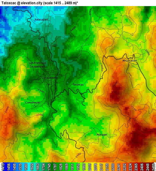
Below is the Elevation map of Tatoxcac, which displays elevation range with different colors. Scale of the first map is from 1415 to 2489 m (4642 to 8166 ft) with average elevation of 1968.6 meters (=6459 ft) [note 1]
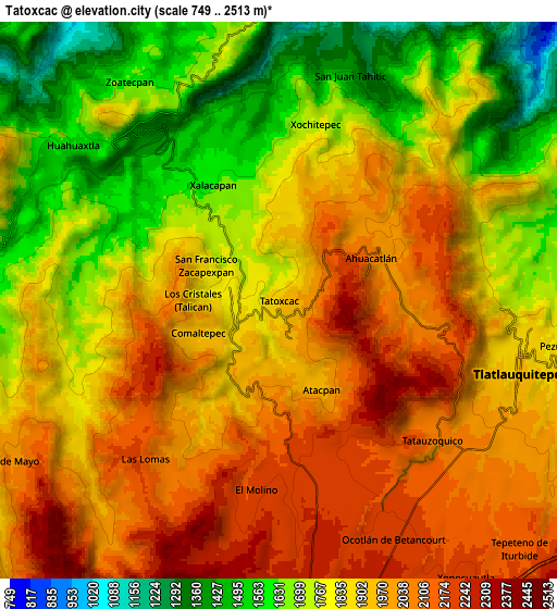
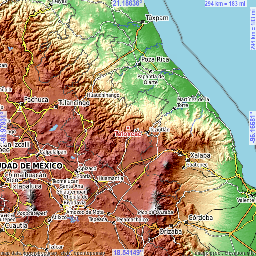
These maps also provides idea of topography and contour of this city, they are displayed at different zoom levels. More info about maps, scale and edge coordinates you can find below images.
| \ | Map #1 | Map #2 | Topo.Map |
| Scale [m] | 1415..2489 m | 749..2513 m | × |
| Scale [ft] | 4642..8166 ft | 2457..8245 ft | × |
| Average | 1968.6 m = 6459 ft | 1869.5 m = 6134 ft | × |
| Width | 9.19 km = 5.7 mi | 18.38 km = 11.4 mi | 294.1 km = 182.7 mi |
| Height | 9.19 km = 5.7 mi | 18.38 km = 11.4 mi | 294.1 km = 182.7 mi |
| ↑Max Latitude | 19.910764° | 19.952077° | 21.18636° |
| Latitude at center | 19.86944° | 19.86944° | 19.86944° |
| ↓Min Latitude | 19.828105° | 19.78676° | 18.54149° |
| ← Min Longitude | -97.617005° | -97.660951° | -98.97931° |
| Longitude center | -97.57306° | -97.57306° | -97.57306° |
| →Max Longitude | -97.529115° | -97.485169° | -96.16681° |
Nearby cities:
Cities around Tatoxcac sort by population:
• Zacapoaxtla elevation 1826 m
1.7 km,  282°
282°
• Xalacapan de Lucke 1631 m
4.3 km,  334°
334°
• Las Lomas 2073 m
6.5 km,  219°
219°
• Comaltepec 1920 m
3 km,  246°
246°
• San Francisco Zacapexpan 1843 m
2.7 km,  296°
296°
• Los Cristales (Talican) 1795 m
2.2 km, 278°
• Ahuacatlán 2079 m
3.3 km,  63°
63°
• Santa Cruz Xaltetela 1817 m
1 km, 302°
• Atalpan 1947 m
3.2 km,  154°
154°
• El Molino 2197 m
6.3 km,  186°
186°
• Xalticpac 1973 m
3.8 km, 218°
• Nexticapan 2202 m
5.1 km,  157°
157°
Multilingual:
 En español:
Tatoxcac elevación 1888 m.
 En France:
Tatoxcac élévation 1888 m.
 Auf Deutsch:
Tatoxcac höhe über dem Meeresspiegel ist 1888 m.

Sources and notes:
- [note 1] Map square and city borders are not equal. Map elevation data is calculated only from area inside that square.
- [src 1] Elevation data from geonames database provided with same terms of usage.
- [src 2] The elevation map of Tatoxcac is generated using elevation data from NASA's 3 arcsec (90m) resolution SRTM data.
- [src 3] Base (background) map © OpenStreetMap contributors tiles are generated by Geofabrik and OpenTopoMap.
Copyright & License:
This Tatoxcac Elevation Map is licensed under CC BY-SA. You may reuse any part from this page, if you give a proper credit by linking to this URL:
 More info on terms of use page.