Nauzontla elevation
Nauzontla (Puebla), Mexico elevation is 1433 meters and Nauzontla elevation in feet is 4701 ft above sea level [src 1]. Nauzontla is a populated place (feature code) with elevation that is 119 meters (390 ft) bigger than average city elevation in Mexico.
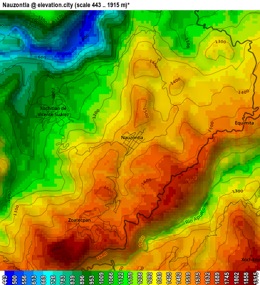
Below is the Elevation map of Nauzontla, which displays elevation range with different colors. Scale of the first map is from 443 to 1915 m (1453 to 6283 ft) with average elevation of 1306.4 meters (=4286 ft) [note 1]
These maps also provides idea of topography and contour of this city, they are displayed at different zoom levels. More info about maps, scale and edge coordinates you can find below images.
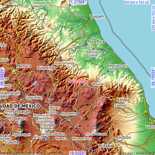
| \ | Map #1 | Topo.Map |
| Scale [m] | 443..1915 m | × |
| Scale [ft] | 1453..6283 ft | × |
| Average | 1306.4 m = 4286 ft | × |
| Width | 9.19 km = 5.7 mi | 293.9 km = 182.6 mi |
| Height | 9.19 km = 5.7 mi | 293.9 km = 182.6 mi |
| ↑Max Latitude | 20.00082° | 21.27566° |
| Latitude at center | 19.95952° | 19.95952° |
| ↓Min Latitude | 19.918209° | 18.6323° |
| ← Min Longitude | -97.647085° | -99.00939° |
| Longitude center | -97.60314° | -97.60314° |
| →Max Longitude | -97.559195° | -96.19689° |
Nearby cities:
Cities around Nauzontla sort by population:
• Xalacapan de Lucke elevation 1631 m
6.3 km,  167°
167°
• Ixtepec 1059 m
8.5 km,  328°
328°
• San Juan Tahitic 1448 m
6.1 km,  115°
115°
• Zoatecpan 1609 m
3.3 km,  212°
212°
• Huahuaxtla 1561 m
6 km,  216°
216°
• Tuxtla 908 m
7.1 km,  309°
309°
• San Miguel del Progreso 900 m
7.4 km,  296°
296°
• San Francisco Zacapexpan 1843 m
8.8 km,  175°
175°
• Atlequizayan 809 m
6.3 km,  339°
339°
• Ignacio Allende (Concepción) 880 m
6.6 km, 330°
• Jonotla 1011 m
8.4 km,  20°
20°
• Zoquiopan 1048 m
5.5 km,  7°
7°
Multilingual:
 En español:
Nauzontla elevación 1433 m.
 En France:
Nauzontla élévation 1433 m.
 Auf Deutsch:
Nauzontla höhe über dem Meeresspiegel ist 1433 m.

Sources and notes:
- [note 1] Map square and city borders are not equal. Map elevation data is calculated only from area inside that square.
- [src 1] Elevation data from geonames database provided with same terms of usage.
- [src 2] The elevation map of Nauzontla is generated using elevation data from NASA's 3 arcsec (90m) resolution SRTM data.
- [src 3] Base (background) map © OpenStreetMap contributors tiles are generated by Geofabrik and OpenTopoMap.
Copyright & License:
This Nauzontla Elevation Map is licensed under CC BY-SA. You may reuse any part from this page, if you give a proper credit by linking to this URL:
 More info on terms of use page.