Coatepec elevation
Coatepec (State of Mexico, Ixtapaluca), Mexico elevation is 2420 meters and Coatepec elevation in feet is 7940 ft above sea level [src 1]. Coatepec is a populated place (feature code) with elevation that is 1106 meters (3629 ft) bigger than average city elevation in Mexico.
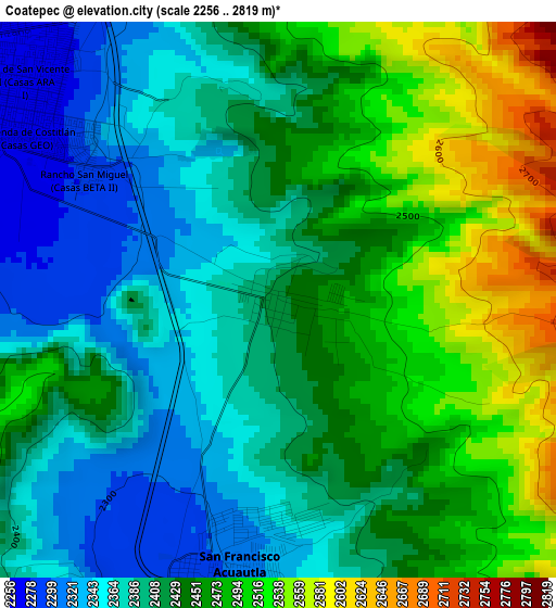
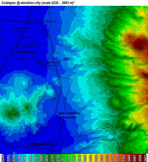
Below is the Elevation map of Coatepec, which displays elevation range with different colors. Scale of the first map is from 2256 to 2819 m (7402 to 9249 ft) with average elevation of 2430 meters (=7972 ft) [note 1]
These maps also provides idea of topography and contour of this city, they are displayed at different zoom levels. More info about maps, scale and edge coordinates you can find below images.
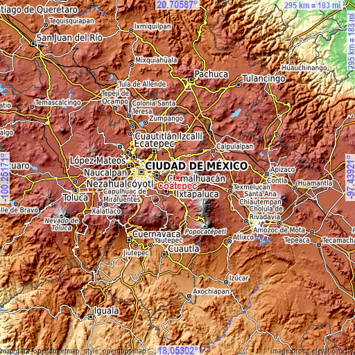
| \ | Map #1 | Map #2 | Topo.Map |
| Scale [m] | 2256..2819 m | 2230..3603 m | × |
| Scale [ft] | 7402..9249 ft | 7316..11821 ft | × |
| Average | 2430 m = 7972 ft | 2514.6 m = 8250 ft | × |
| Width | 9.22 km = 5.7 mi | 18.44 km = 11.5 mi | 295 km = 183.3 mi |
| Height | 9.22 km = 5.7 mi | 18.44 km = 11.5 mi | 295 km = 183.3 mi |
| ↑Max Latitude | 19.426299° | 19.467737° | 20.70587° |
| Latitude at center | 19.38485° | 19.38485° | 19.38485° |
| ↓Min Latitude | 19.343391° | 19.301921° | 18.05302° |
| ← Min Longitude | -98.889405° | -98.933351° | -100.25171° |
| Longitude center | -98.84546° | -98.84546° | -98.84546° |
| →Max Longitude | -98.801515° | -98.757569° | -97.43921° |
Nearby cities:
Cities around Coatepec sort by population:
• Ixtapaluca elevation 2253 m
8.6 km,  206°
206°
• Chicoloapan 2250 m
6.9 km,  300°
300°
• San Buenaventura 2278 m
9.3 km,  191°
191°
• San Francisco Acuautla 2288 m
4.6 km,  199°
199°
• San Miguel Coatlinchán 2313 m
7.8 km,  338°
338°
• Lomas de San Sebastián 2308 m
9.2 km,  268°
268°
• Santiago Cuautlalpan 2254 m
7.9 km,  311°
311°
• Jorge Jiménez Cantú 2309 m
8.4 km,  180°
180°
• San José las Palmas 2379 m
9.5 km,  258°
258°
• Santa Martha 2237 m
9.2 km, 304°
• Zoquiapan 2275 m
7.5 km, 183°
• Colonia Lázaro Cárdenas 2255 m
9.2 km,  317°
317°
Multilingual:
 En español:
Coatepec elevación 2420 m.
 En France:
Coatepec élévation 2420 m.
 Auf Deutsch:
Coatepec höhe über dem Meeresspiegel ist 2420 m.

Sources and notes:
- [note 1] Map square and city borders are not equal. Map elevation data is calculated only from area inside that square.
- [src 1] Elevation data from geonames database provided with same terms of usage.
- [src 2] The elevation map of Coatepec is generated using elevation data from NASA's 3 arcsec (90m) resolution SRTM data.
- [src 3] Base (background) map © OpenStreetMap contributors tiles are generated by Geofabrik and OpenTopoMap.
Copyright & License:
This Coatepec Elevation Map is licensed under CC BY-SA. You may reuse any part from this page, if you give a proper credit by linking to this URL:
 More info on terms of use page.