Querétaro elevation
Querétaro (Chiapas, Ángel Albino Corzo), Mexico elevation is 683 meters and Querétaro elevation in feet is 2241 ft above sea level [src 1]. Querétaro is a populated place (feature code) with elevation that is 631 meters (2070 ft) smaller than average city elevation in Mexico.
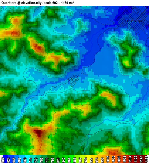
Below is the Elevation map of Querétaro, which displays elevation range with different colors. Scale of the first map is from 602 to 1169 m (1975 to 3835 ft) with average elevation of 755.4 meters (=2478 ft) [note 1]
These maps also provides idea of topography and contour of this city, they are displayed at different zoom levels. More info about maps, scale and edge coordinates you can find below images.
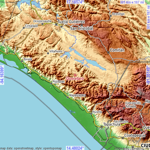
| \ | Map #1 | Topo.Map |
| Scale [m] | 602..1169 m | × |
| Scale [ft] | 1975..3835 ft | × |
| Average | 755.4 m = 2478 ft | × |
| Width | 9.4 km = 5.8 mi | 300.8 km = 186.9 mi |
| Height | 9.4 km = 5.8 mi | 300.8 km = 186.9 mi |
| ↑Max Latitude | 15.879793° | 17.18574° |
| Latitude at center | 15.83752° | 15.83752° |
| ↓Min Latitude | 15.795238° | 14.48024° |
| ← Min Longitude | -92.801685° | -94.16399° |
| Longitude center | -92.75774° | -92.75774° |
| →Max Longitude | -92.713795° | -91.35149° |
Nearby cities:
Cities around Querétaro sort by population:
• Jaltenango de la Paz elevation 641 m
5.3 km,  42°
42°
• Nueva Palestina 737 m
3.6 km,  167°
167°
• Benito Juárez 568 m
23.7 km,  344°
344°
• Montecristo 1227 m
21.8 km,  137°
137°
• La Tigrilla 599 m
19.5 km,  328°
328°
• Dolores Jaltenango 636 m
6.9 km, 342°
• Francisco I. Madero 674 m
7.9 km,  100°
100°
• Unión Buenavista 1788 m
23.3 km, 101°
• Nueva Colombia 1350 m
16.1 km, 165°
• Reforma 581 m
13.4 km,  47°
47°
• Laguna del Cofre 1825 m
26.5 km,  151°
151°
• El Ramal (Porvenir) 675 m
20.3 km,  278°
278°
Multilingual:
 En español:
Querétaro elevación 683 m.
 En France:
Querétaro élévation 683 m.
 Auf Deutsch:
Querétaro höhe über dem Meeresspiegel ist 683 m.

Sources and notes:
- [note 1] Map square and city borders are not equal. Map elevation data is calculated only from area inside that square.
- [src 1] Elevation data from geonames database provided with same terms of usage.
- [src 2] The elevation map of Querétaro is generated using elevation data from NASA's 3 arcsec (90m) resolution SRTM data.
- [src 3] Base (background) map © OpenStreetMap contributors tiles are generated by Geofabrik and OpenTopoMap.
Copyright & License:
This Querétaro Elevation Map is licensed under CC BY-SA. You may reuse any part from this page, if you give a proper credit by linking to this URL:
 More info on terms of use page.