Reforma elevation
Reforma (Chiapas, La Concordia), Mexico elevation is 581 meters and Reforma elevation in feet is 1906 ft above sea level [src 1]. Reforma is a populated place (feature code) with elevation that is 733 meters (2405 ft) smaller than average city elevation in Mexico.
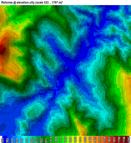
Below is the Elevation map of Reforma, which displays elevation range with different colors. Scale of the first map is from 533 to 1797 m (1749 to 5896 ft) with average elevation of 860.3 meters (=2823 ft) [note 1]
These maps also provides idea of topography and contour of this city, they are displayed at different zoom levels. More info about maps, scale and edge coordinates you can find below images.
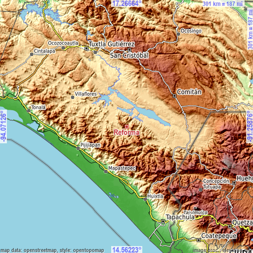
| \ | Map #1 | Topo.Map |
| Scale [m] | 533..1797 m | × |
| Scale [ft] | 1749..5896 ft | × |
| Average | 860.3 m = 2823 ft | × |
| Width | 9.4 km = 5.8 mi | 300.7 km = 186.8 mi |
| Height | 9.4 km = 5.8 mi | 300.7 km = 186.8 mi |
| ↑Max Latitude | 15.961246° | 17.26664° |
| Latitude at center | 15.91899° | 15.91899° |
| ↓Min Latitude | 15.876726° | 14.56223° |
| ← Min Longitude | -92.708955° | -94.07126° |
| Longitude center | -92.66501° | -92.66501° |
| →Max Longitude | -92.621065° | -91.25876° |
Nearby cities:
Cities around Reforma sort by population:
• Jaltenango de la Paz elevation 641 m
8.1 km,  231°
231°
• La Concordia 549 m
22.3 km,  353°
353°
• Nueva Palestina 737 m
15.5 km,  216°
216°
• Benito Juárez 568 m
21.4 km,  309°
309°
• La Tigrilla 599 m
21.4 km,  290°
290°
• Querétaro 683 m
13.4 km, 227°
• Dolores Jaltenango 636 m
12.3 km,  258°
258°
• Francisco I. Madero 674 m
10.7 km,  191°
191°
• Unión Buenavista 1788 m
18.9 km,  136°
136°
• Rizo de Oro 554 m
20.3 km,  73°
73°
• Ignacio Zaragoza 547 m
14.6 km,  34°
34°
• Nueva Libertad 556 m
24.4 km,  321°
321°
Multilingual:
 En español:
Reforma elevación 581 m.
 En France:
Reforma élévation 581 m.


Sources and notes:
- [note 1] Map square and city borders are not equal. Map elevation data is calculated only from area inside that square.
- [src 1] Elevation data from geonames database provided with same terms of usage.
- [src 2] The elevation map of Reforma is generated using elevation data from NASA's 3 arcsec (90m) resolution SRTM data.
- [src 3] Base (background) map © OpenStreetMap contributors tiles are generated by Geofabrik and OpenTopoMap.
Copyright & License:
This Reforma Elevation Map is licensed under CC BY-SA. You may reuse any part from this page, if you give a proper credit by linking to this URL:
 More info on terms of use page.