Emiliano Zapata elevation
Emiliano Zapata (Chiapas, Villa Corzo), Mexico elevation is 611 meters and Emiliano Zapata elevation in feet is 2005 ft above sea level [src 1]. Emiliano Zapata is a populated place (feature code) with elevation that is 703 meters (2306 ft) smaller than average city elevation in Mexico.
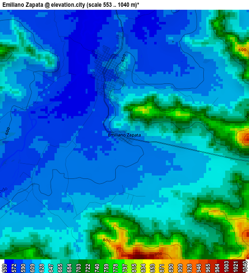
Below is the Elevation map of Emiliano Zapata, which displays elevation range with different colors. Scale of the first map is from 553 to 1040 m (1814 to 3412 ft) with average elevation of 638.1 meters (=2094 ft) [note 1]
These maps also provides idea of topography and contour of this city, they are displayed at different zoom levels. More info about maps, scale and edge coordinates you can find below images.
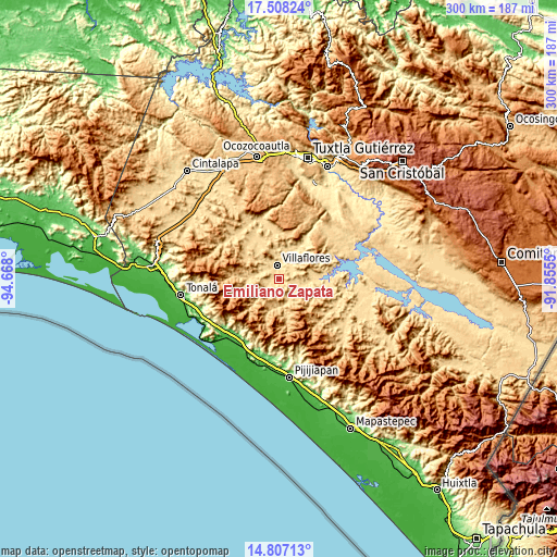
| \ | Map #1 | Topo.Map |
| Scale [m] | 553..1040 m | × |
| Scale [ft] | 1814..3412 ft | × |
| Average | 638.1 m = 2094 ft | × |
| Width | 9.39 km = 5.8 mi | 300.3 km = 186.6 mi |
| Height | 9.39 km = 5.8 mi | 300.4 km = 186.7 mi |
| ↑Max Latitude | 16.204504° | 17.50824° |
| Latitude at center | 16.1623° | 16.1623° |
| ↓Min Latitude | 16.120087° | 14.80713° |
| ← Min Longitude | -93.305695° | -94.668° |
| Longitude center | -93.26175° | -93.26175° |
| →Max Longitude | -93.217805° | -91.8555° |
Nearby cities:
Cities around Emiliano Zapata sort by population:
• Villaflores elevation 571 m
8 km,  353°
353°
• Villa Corzo 592 m
2.6 km,  343°
343°
• San Pedro Buenavista 636 m
17.8 km,  119°
119°
• Revolución Mexicana 550 m
19.8 km,  87°
87°
• Cuauhtémoc 564 m
17.8 km,  17°
17°
• Villa Hidalgo 537 m
19.5 km,  35°
35°
• Joaquín Miguel Gutiérrez 636 m
25.6 km,  334°
334°
• Manuel Ávila Camacho 548 m
26.2 km, 93°
• Francisco Villa 606 m
9.9 km,  305°
305°
• Dieciséis de Septiembre 530 m
17.6 km,  31°
31°
• Monterrey 686 m
16 km,  225°
225°
• Calzada Larga 709 m
21.8 km, 344°
Multilingual:
 En español:
Emiliano Zapata elevación 611 m.
 En France:
Emiliano Zapata élévation 611 m.
 Auf Deutsch:
Emiliano Zapata höhe über dem Meeresspiegel ist 611 m.

Sources and notes:
- [note 1] Map square and city borders are not equal. Map elevation data is calculated only from area inside that square.
- [src 1] Elevation data from geonames database provided with same terms of usage.
- [src 2] The elevation map of Emiliano Zapata is generated using elevation data from NASA's 3 arcsec (90m) resolution SRTM data.
- [src 3] Base (background) map © OpenStreetMap contributors tiles are generated by Geofabrik and OpenTopoMap.
Copyright & License:
This Emiliano Zapata Elevation Map is licensed under CC BY-SA. You may reuse any part from this page, if you give a proper credit by linking to this URL:
 More info on terms of use page.