Villaflores elevation
Villaflores (Chiapas), Mexico elevation is 571 meters and Villaflores elevation in feet is 1873 ft above sea level [src 1]. Villaflores is a seat of a second-order administrative division (feature code) with elevation that is 743 meters (2438 ft) smaller than average city elevation in Mexico.
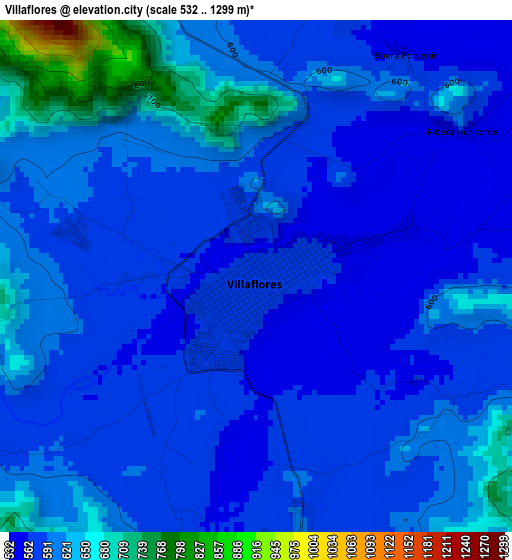
Below is the Elevation map of Villaflores, which displays elevation range with different colors. Scale of the first map is from 532 to 1299 m (1745 to 4262 ft) with average elevation of 598.1 meters (=1962 ft) [note 1]
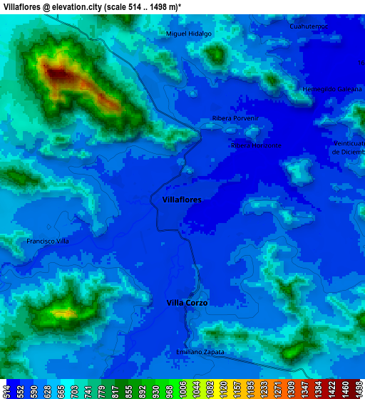
These maps also provides idea of topography and contour of this city, they are displayed at different zoom levels. More info about maps, scale and edge coordinates you can find below images.
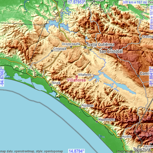
| \ | Map #1 | Map #2 | Topo.Map |
| Scale [m] | 532..1299 m | 514..1498 m | × |
| Scale [ft] | 1745..4262 ft | 1686..4915 ft | × |
| Average | 598.1 m = 1962 ft | 644 m = 2113 ft | × |
| Width | 9.38 km = 5.8 mi | 18.77 km = 11.7 mi | 300.2 km = 186.5 mi |
| Height | 9.38 km = 5.8 mi | 18.77 km = 11.7 mi | 300.2 km = 186.5 mi |
| ↑Max Latitude | 16.276289° | 16.318468° | 17.57953° |
| Latitude at center | 16.2341° | 16.2341° | 16.2341° |
| ↓Min Latitude | 16.191902° | 16.149696° | 14.8794° |
| ← Min Longitude | -93.314315° | -93.358261° | -94.67662° |
| Longitude center | -93.27037° | -93.27037° | -93.27037° |
| →Max Longitude | -93.226425° | -93.182479° | -91.86412° |
Nearby cities:
Cities around Villaflores sort by population:
• Villa Corzo elevation 592 m
5.5 km,  178°
178°
• Revolución Mexicana 550 m
21.8 km,  108°
108°
• Jesús María Garza 630 m
18.2 km,  352°
352°
• Cuauhtémoc 564 m
11 km,  35°
35°
• Doctor Domingo Chanona 663 m
20 km,  308°
308°
• Villa Hidalgo 537 m
14.6 km,  57°
57°
• Joaquín Miguel Gutiérrez 636 m
18.2 km,  326°
326°
• Emiliano Zapata 611 m
8 km,  173°
173°
• Francisco Villa 606 m
7.4 km,  252°
252°
• Dieciséis de Septiembre 530 m
12.4 km, 55°
• Ignacio Zaragoza 535 m
21.1 km, 43°
• Calzada Larga 709 m
13.9 km,  339°
339°
Multilingual:
 En español:
Villaflores elevación 571 m.
 En France:
Villaflores élévation 571 m.
 Auf Deutsch:
Villaflores höhe über dem Meeresspiegel ist 571 m.

Sources and notes:
- [note 1] Map square and city borders are not equal. Map elevation data is calculated only from area inside that square.
- [src 1] Elevation data from geonames database provided with same terms of usage.
- [src 2] The elevation map of Villaflores is generated using elevation data from NASA's 3 arcsec (90m) resolution SRTM data.
- [src 3] Base (background) map © OpenStreetMap contributors tiles are generated by Geofabrik and OpenTopoMap.
Copyright & License:
This Villaflores Elevation Map is licensed under CC BY-SA. You may reuse any part from this page, if you give a proper credit by linking to this URL:
 More info on terms of use page.