Manuel Ávila Camacho elevation
Manuel Ávila Camacho (Chiapas, Villa Corzo), Mexico elevation is 548 meters and Manuel Ávila Camacho elevation in feet is 1798 ft above sea level [src 1]. Manuel Ávila Camacho is a populated place (feature code) with elevation that is 766 meters (2513 ft) smaller than average city elevation in Mexico.
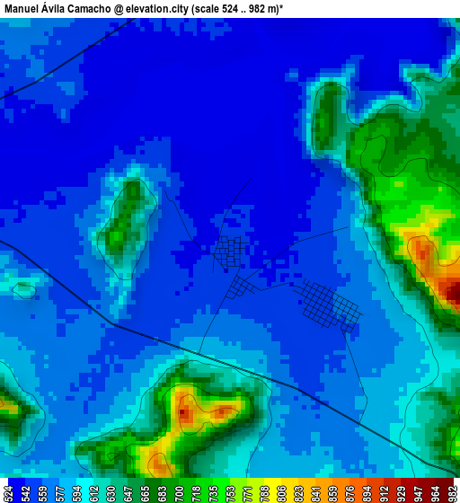
Below is the Elevation map of Manuel Ávila Camacho, which displays elevation range with different colors. Scale of the first map is from 524 to 982 m (1719 to 3222 ft) with average elevation of 586.3 meters (=1924 ft) [note 1]
These maps also provides idea of topography and contour of this city, they are displayed at different zoom levels. More info about maps, scale and edge coordinates you can find below images.
| \ | Map #1 | Topo.Map |
| Scale [m] | 524..982 m | × |
| Scale [ft] | 1719..3222 ft | × |
| Average | 586.3 m = 1924 ft | × |
| Width | 9.39 km = 5.8 mi | 300.4 km = 186.7 mi |
| Height | 9.39 km = 5.8 mi | 300.4 km = 186.7 mi |
| ↑Max Latitude | 16.188677° | 17.49253° |
| Latitude at center | 16.14647° | 16.14647° |
| ↓Min Latitude | 16.104254° | 14.7912° |
| ← Min Longitude | -93.060955° | -94.42326° |
| Longitude center | -93.01701° | -93.01701° |
| →Max Longitude | -92.973065° | -91.61076° |
Nearby cities:
Cities around Manuel Ávila Camacho sort by population:
• San Pedro Buenavista elevation 636 m
12.8 km,  236°
236°
• Revolución Mexicana 550 m
7 km,  293°
293°
• Nuevo Vicente Guerrero 605 m
12.8 km,  159°
159°
• Benito Juárez 568 m
24.1 km,  118°
118°
• El Ámbar (El Ámbar de Echeverría) 561 m
20.4 km,  105°
105°
• Villa Hidalgo 537 m
22.9 km,  320°
320°
• Jericó 634 m
16.6 km,  19°
19°
• Diamante de Echeverría 577 m
15.2 km,  104°
104°
• Independencia 566 m
20.2 km, 109°
• Plan de Agua Prieta 559 m
24.2 km,  94°
94°
• Dieciséis de Septiembre 530 m
23.8 km,  314°
314°
• Nueva Libertad 556 m
23.2 km, 105°
Multilingual:
 En español:
Manuel Ávila Camacho elevación 548 m.
 En France:
Manuel Ávila Camacho élévation 548 m.
 Auf Deutsch:
Manuel Ávila Camacho höhe über dem Meeresspiegel ist 548 m.
 На русском:
Manuel Ávila Camacho высота над уровнем моря 548 м
Sources and notes:
- [note 1] Map square and city borders are not equal. Map elevation data is calculated only from area inside that square.
- [src 1] Elevation data from geonames database provided with same terms of usage.
- [src 2] The elevation map of Manuel Ávila Camacho is generated using elevation data from NASA's 3 arcsec (90m) resolution SRTM data.
- [src 3] Base (background) map © OpenStreetMap contributors tiles are generated by Geofabrik and OpenTopoMap.
Copyright & License:
This Manuel Ávila Camacho Elevation Map is licensed under CC BY-SA. You may reuse any part from this page, if you give a proper credit by linking to this URL:
 More info on terms of use page.