Jericó elevation
Jericó (Chiapas, Villa Corzo), Mexico elevation is 634 meters and Jericó elevation in feet is 2080 ft above sea level [src 1]. Jericó is a populated place (feature code) with elevation that is 680 meters (2231 ft) smaller than average city elevation in Mexico.
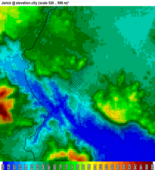
Below is the Elevation map of Jericó, which displays elevation range with different colors. Scale of the first map is from 520 to 998 m (1706 to 3274 ft) with average elevation of 650.5 meters (=2134 ft) [note 1]
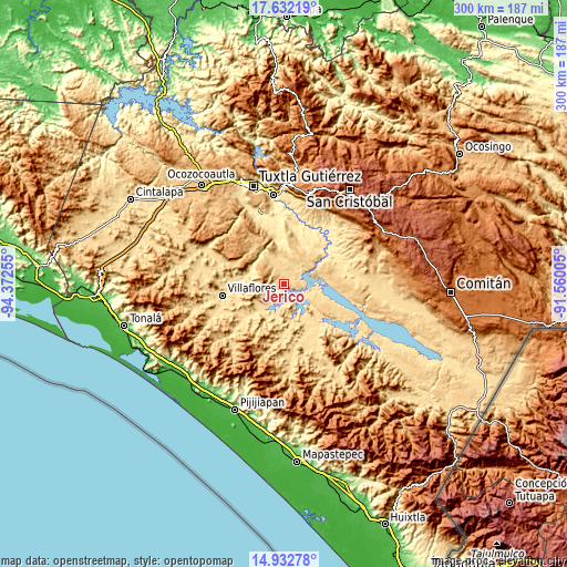
These maps also provides idea of topography and contour of this city, they are displayed at different zoom levels. More info about maps, scale and edge coordinates you can find below images.
| \ | Map #1 | Topo.Map |
| Scale [m] | 520..998 m | × |
| Scale [ft] | 1706..3274 ft | × |
| Average | 650.5 m = 2134 ft | × |
| Width | 9.38 km = 5.8 mi | 300.1 km = 186.5 mi |
| Height | 9.38 km = 5.8 mi | 300.2 km = 186.5 mi |
| ↑Max Latitude | 16.329307° | 17.63219° |
| Latitude at center | 16.28713° | 16.28713° |
| ↓Min Latitude | 16.244944° | 14.93278° |
| ← Min Longitude | -93.010245° | -94.37255° |
| Longitude center | -92.9663° | -92.9663° |
| →Max Longitude | -92.922355° | -91.56005° |
Nearby cities:
Cities around Jericó sort by population:
• El Parral elevation 656 m
10.2 km,  335°
335°
• Revolución Mexicana 550 m
17.4 km,  222°
222°
• El Ámbar (El Ámbar de Echeverría) 561 m
25.5 km,  146°
146°
• Villa Hidalgo 537 m
20.2 km,  275°
275°
• Julián Grajales 472 m
22.2 km,  359°
359°
• Diamante de Echeverría 577 m
21.6 km, 154°
• Nuevo Vicente Guerrero (El Chichonal) 503 m
24.2 km,  24°
24°
• Plan de Agua Prieta 559 m
25.5 km,  132°
132°
• Manuel Ávila Camacho 548 m
16.6 km,  199°
199°
• Nicolás Bravo 466 m
25 km,  353°
353°
• Dieciséis de Septiembre 530 m
22.3 km,  272°
272°
• Ignacio Zaragoza 535 m
20.3 km,  297°
297°
Multilingual:
 En español:
Jericó elevación 634 m.
 En France:
Jericó élévation 634 m.


Sources and notes:
- [note 1] Map square and city borders are not equal. Map elevation data is calculated only from area inside that square.
- [src 1] Elevation data from geonames database provided with same terms of usage.
- [src 2] The elevation map of Jericó is generated using elevation data from NASA's 3 arcsec (90m) resolution SRTM data.
- [src 3] Base (background) map © OpenStreetMap contributors tiles are generated by Geofabrik and OpenTopoMap.
Copyright & License:
This Jericó Elevation Map is licensed under CC BY-SA. You may reuse any part from this page, if you give a proper credit by linking to this URL:
 More info on terms of use page.