El Parral elevation
El Parral (Chiapas, Villa Corzo), Mexico elevation is 656 meters and El Parral elevation in feet is 2152 ft above sea level [src 1]. El Parral is a populated place (feature code) with elevation that is 658 meters (2159 ft) smaller than average city elevation in Mexico.
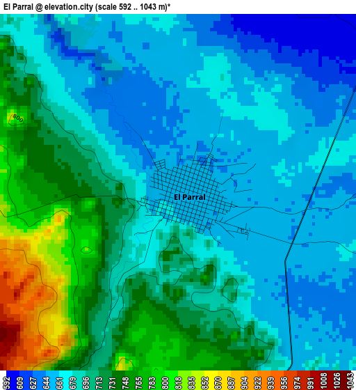
Below is the Elevation map of El Parral, which displays elevation range with different colors. Scale of the first map is from 592 to 1043 m (1942 to 3422 ft) with average elevation of 696.6 meters (=2285 ft) [note 1]
These maps also provides idea of topography and contour of this city, they are displayed at different zoom levels. More info about maps, scale and edge coordinates you can find below images.
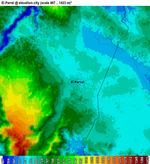
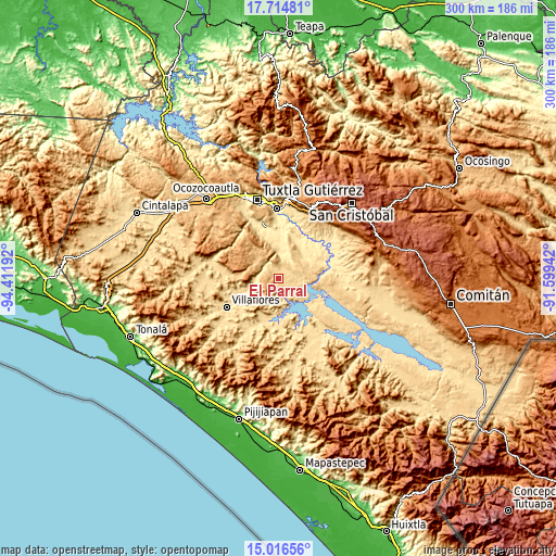
| \ | Map #1 | Map #2 | Topo.Map |
| Scale [m] | 592..1043 m | 467..1423 m | × |
| Scale [ft] | 1942..3422 ft | 1532..4669 ft | × |
| Average | 696.6 m = 2285 ft | 732 m = 2402 ft | × |
| Width | 9.38 km = 5.8 mi | 18.75 km = 11.7 mi | 300 km = 186.4 mi |
| Height | 9.38 km = 5.8 mi | 18.75 km = 11.7 mi | 300 km = 186.4 mi |
| ↑Max Latitude | 16.412509° | 16.454659° | 17.71481° |
| Latitude at center | 16.37035° | 16.37035° | 16.37035° |
| ↓Min Latitude | 16.328182° | 16.286004° | 15.01656° |
| ← Min Longitude | -93.049615° | -93.093561° | -94.41192° |
| Longitude center | -93.00567° | -93.00567° | -93.00567° |
| →Max Longitude | -92.961725° | -92.917779° | -91.59942° |
Nearby cities:
Cities around El Parral sort by population:
• Revolución Mexicana elevation 550 m
23.4 km,  198°
198°
• Cuauhtémoc 564 m
22.7 km,  254°
254°
• Villa Hidalgo 537 m
17.5 km, 245°
• Jericó 634 m
10.2 km,  155°
155°
• Julián Grajales 472 m
13.5 km,  16°
16°
• Nuevo Vicente Guerrero (El Chichonal) 503 m
19.2 km,  48°
48°
• Unión Buena Vista 533 m
23.8 km,  57°
57°
• Ignacio Allende 443 m
17.3 km,  4°
4°
• Narciso Mendoza 435 m
23.4 km, 4°
• Nicolás Bravo 466 m
15.7 km,  5°
5°
• Dieciséis de Septiembre 530 m
19.8 km, 245°
• Ignacio Zaragoza 535 m
13.7 km,  270°
270°
Multilingual:
 En español:
El Parral elevación 656 m.
 En France:
El Parral élévation 656 m.
 Auf Deutsch:
El Parral höhe über dem Meeresspiegel ist 656 m.

Sources and notes:
- [note 1] Map square and city borders are not equal. Map elevation data is calculated only from area inside that square.
- [src 1] Elevation data from geonames database provided with same terms of usage.
- [src 2] The elevation map of El Parral is generated using elevation data from NASA's 3 arcsec (90m) resolution SRTM data.
- [src 3] Base (background) map © OpenStreetMap contributors tiles are generated by Geofabrik and OpenTopoMap.
Copyright & License:
This El Parral Elevation Map is licensed under CC BY-SA. You may reuse any part from this page, if you give a proper credit by linking to this URL:
 More info on terms of use page.