El Puerto elevation
El Puerto (Chiapas, Venustiano Carranza), Mexico elevation is 1235 meters and El Puerto elevation in feet is 4052 ft above sea level [src 1]. El Puerto is a populated place (feature code) with elevation that is 79 meters (259 ft) smaller than average city elevation in Mexico.
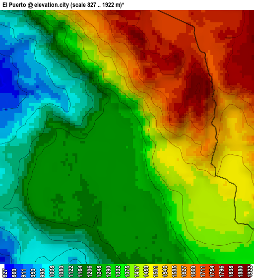
Below is the Elevation map of El Puerto, which displays elevation range with different colors. Scale of the first map is from 827 to 1922 m (2713 to 6306 ft) with average elevation of 1359.5 meters (=4460 ft) [note 1]
These maps also provides idea of topography and contour of this city, they are displayed at different zoom levels. More info about maps, scale and edge coordinates you can find below images.
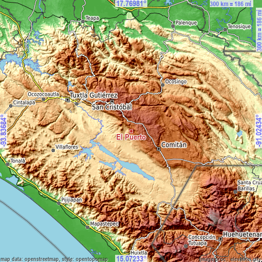
| \ | Map #1 | Topo.Map |
| Scale [m] | 827..1922 m | × |
| Scale [ft] | 2713..6306 ft | × |
| Average | 1359.5 m = 4460 ft | × |
| Width | 9.37 km = 5.8 mi | 299.9 km = 186.3 mi |
| Height | 9.37 km = 5.8 mi | 300 km = 186.4 mi |
| ↑Max Latitude | 16.467897° | 17.76981° |
| Latitude at center | 16.42575° | 16.42575° |
| ↓Min Latitude | 16.383594° | 15.07233° |
| ← Min Longitude | -92.474535° | -93.83684° |
| Longitude center | -92.43059° | -92.43059° |
| →Max Longitude | -92.386645° | -91.02434° |
Nearby cities:
Cities around El Puerto sort by population:
• Las Rosas elevation 1312 m
9.3 km,  136°
136°
• Teopisca 1781 m
13.7 km,  340°
340°
• Venustiano Carranza 775 m
17.2 km,  235°
235°
• San Francisco Pujiltic 625 m
16.5 km,  188°
188°
• Amatenango del Valle 1818 m
11.3 km,  357°
357°
• Nicolás Ruiz 751 m
16.5 km,  274°
274°
• Soyatitán 853 m
14.6 km,  177°
177°
• Aguacatenango 1750 m
5.8 km,  23°
23°
• Nuevo León 1130 m
16.5 km,  294°
294°
• Guadalupe Victoria 967 m
13.2 km,  259°
259°
• La Floresta 2177 m
15.6 km,  53°
53°
• Mariano Matamoros 1051 m
17.6 km, 290°
Multilingual:
 En español:
El Puerto elevación 1235 m.
 En France:
El Puerto élévation 1235 m.
 Auf Deutsch:
El Puerto höhe über dem Meeresspiegel ist 1235 m.

Sources and notes:
- [note 1] Map square and city borders are not equal. Map elevation data is calculated only from area inside that square.
- [src 1] Elevation data from geonames database provided with same terms of usage.
- [src 2] The elevation map of El Puerto is generated using elevation data from NASA's 3 arcsec (90m) resolution SRTM data.
- [src 3] Base (background) map © OpenStreetMap contributors tiles are generated by Geofabrik and OpenTopoMap.
Copyright & License:
This El Puerto Elevation Map is licensed under CC BY-SA. You may reuse any part from this page, if you give a proper credit by linking to this URL:
 More info on terms of use page.