San Francisco Pujiltic elevation
San Francisco Pujiltic (Chiapas, Venustiano Carranza), Mexico elevation is 625 meters and San Francisco Pujiltic elevation in feet is 2051 ft above sea level [src 1]. San Francisco Pujiltic is a populated place (feature code) with elevation that is 689 meters (2260 ft) smaller than average city elevation in Mexico.
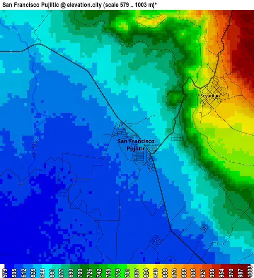
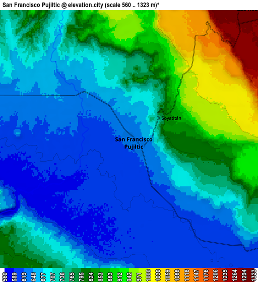
Below is the Elevation map of San Francisco Pujiltic, which displays elevation range with different colors. Scale of the first map is from 579 to 1003 m (1900 to 3291 ft) with average elevation of 672 meters (=2205 ft) [note 1]
These maps also provides idea of topography and contour of this city, they are displayed at different zoom levels. More info about maps, scale and edge coordinates you can find below images.
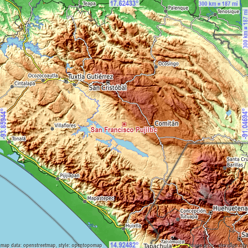
| \ | Map #1 | Map #2 | Topo.Map |
| Scale [m] | 579..1003 m | 560..1323 m | × |
| Scale [ft] | 1900..3291 ft | 1837..4341 ft | × |
| Average | 672 m = 2205 ft | 744.9 m = 2444 ft | × |
| Width | 9.38 km = 5.8 mi | 18.76 km = 11.7 mi | 300.2 km = 186.5 mi |
| Height | 9.38 km = 5.8 mi | 18.76 km = 11.7 mi | 300.2 km = 186.5 mi |
| ↑Max Latitude | 16.321399° | 16.363569° | 17.62433° |
| Latitude at center | 16.27922° | 16.27922° | 16.27922° |
| ↓Min Latitude | 16.237032° | 16.194835° | 14.92482° |
| ← Min Longitude | -92.497135° | -92.541081° | -93.85944° |
| Longitude center | -92.45319° | -92.45319° | -92.45319° |
| →Max Longitude | -92.409245° | -92.365299° | -91.04694° |
Nearby cities:
Cities around San Francisco Pujiltic sort by population:
• Las Rosas elevation 1312 m
13.1 km,  42°
42°
• Venustiano Carranza 775 m
13.4 km,  299°
299°
• Socoltenango 897 m
11.6 km,  109°
109°
• Soyatitán 853 m
3.5 km,  61°
61°
• Aguacatenango 1750 m
22.2 km,  12°
12°
• San Vicente la Mesilla 627 m
20.4 km,  123°
123°
• San Francisco (El Calvito) 638 m
12.5 km,  292°
292°
• Paraíso del Grijalva 667 m
21.1 km,  253°
253°
• Guadalupe Victoria 967 m
17.5 km,  322°
322°
• Miguel Hidalgo 595 m
20.3 km, 292°
• Tzinil 1161 m
14.2 km,  99°
99°
• El Puerto 1235 m
16.5 km, 8°
Multilingual:
 En español:
Pujiltic elevación 625 m.
 En France:
San Francisco Pujiltic élévation 625 m.
 Auf Deutsch:
San Francisco Pujiltic höhe über dem Meeresspiegel ist 625 m.
 На русском:
San Francisco Pujiltic высота над уровнем моря 625 м
Sources and notes:
- [note 1] Map square and city borders are not equal. Map elevation data is calculated only from area inside that square.
- [src 1] Elevation data from geonames database provided with same terms of usage.
- [src 2] The elevation map of San Francisco Pujiltic is generated using elevation data from NASA's 3 arcsec (90m) resolution SRTM data.
- [src 3] Base (background) map © OpenStreetMap contributors tiles are generated by Geofabrik and OpenTopoMap.
Copyright & License:
This San Francisco Pujiltic Elevation Map is licensed under CC BY-SA. You may reuse any part from this page, if you give a proper credit by linking to this URL:
 More info on terms of use page.