Teopisca elevation
Teopisca (Chiapas), Mexico elevation is 1781 meters and Teopisca elevation in feet is 5843 ft above sea level [src 1]. Teopisca is a seat of a second-order administrative division (feature code) with elevation that is 467 meters (1532 ft) bigger than average city elevation in Mexico.
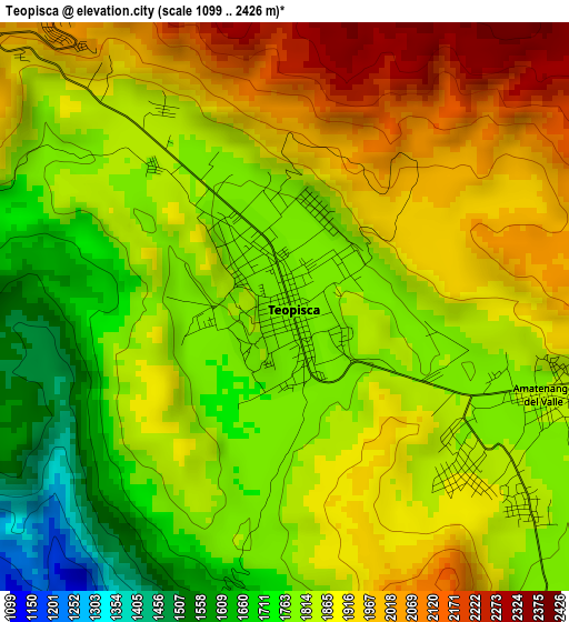
Below is the Elevation map of Teopisca, which displays elevation range with different colors. Scale of the first map is from 1099 to 2426 m (3606 to 7959 ft) with average elevation of 1848.5 meters (=6065 ft) [note 1]
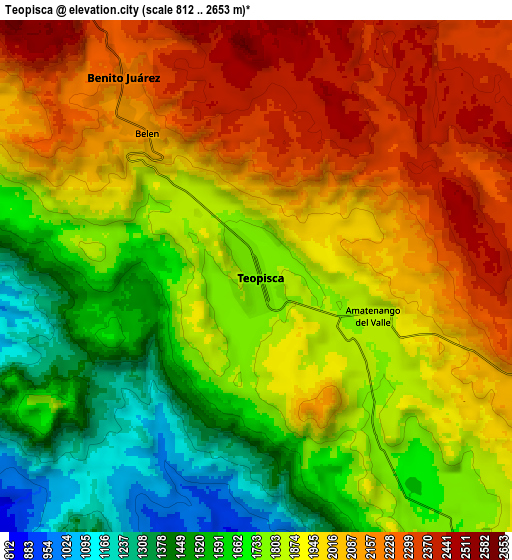
These maps also provides idea of topography and contour of this city, they are displayed at different zoom levels. More info about maps, scale and edge coordinates you can find below images.
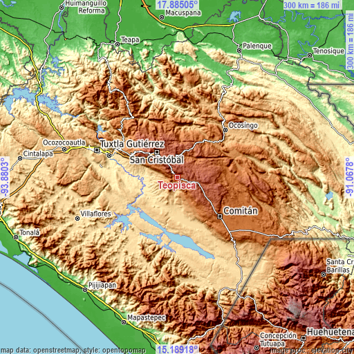
| \ | Map #1 | Map #2 | Topo.Map |
| Scale [m] | 1099..2426 m | 812..2653 m | × |
| Scale [ft] | 3606..7959 ft | 2664..8704 ft | × |
| Average | 1848.5 m = 6065 ft | 1880 m = 6168 ft | × |
| Width | 9.37 km = 5.8 mi | 18.74 km = 11.6 mi | 299.8 km = 186.3 mi |
| Height | 9.37 km = 5.8 mi | 18.74 km = 11.6 mi | 299.8 km = 186.3 mi |
| ↑Max Latitude | 16.583942° | 16.626055° | 17.88505° |
| Latitude at center | 16.54182° | 16.54182° | 16.54182° |
| ↓Min Latitude | 16.499689° | 16.457549° | 15.18918° |
| ← Min Longitude | -92.517995° | -92.561941° | -93.8803° |
| Longitude center | -92.47405° | -92.47405° | -92.47405° |
| →Max Longitude | -92.430105° | -92.386159° | -91.0678° |
Nearby cities:
Cities around Teopisca sort by population:
• Amatenango del Valle elevation 1818 m
4.5 km,  111°
111°
• Nicolás Ruiz 751 m
16.6 km,  225°
225°
• Aguacatenango 1750 m
10.3 km,  137°
137°
• Nuevo León 1130 m
12.1 km,  239°
239°
• Betania 2211 m
8.8 km,  324°
324°
• Mariano Matamoros 1051 m
13.6 km, 240°
• Los Pozos 2247 m
13.8 km,  31°
31°
• Mitzitón 2381 m
13.8 km,  327°
327°
• Lázaro Cárdenas (Chilil) 2298 m
15 km,  353°
353°
• Carmen Yalchuch 2088 m
16.5 km,  46°
46°
• San José Yashitinín 2358 m
12.9 km,  13°
13°
• El Puerto 1235 m
13.7 km,  160°
160°
Multilingual:
 En español:
Teopisca elevación 1781 m.
 En France:
Teopisca élévation 1781 m.
 Auf Deutsch:
Teopisca höhe über dem Meeresspiegel ist 1781 m.

Sources and notes:
- [note 1] Map square and city borders are not equal. Map elevation data is calculated only from area inside that square.
- [src 1] Elevation data from geonames database provided with same terms of usage.
- [src 2] The elevation map of Teopisca is generated using elevation data from NASA's 3 arcsec (90m) resolution SRTM data.
- [src 3] Base (background) map © OpenStreetMap contributors tiles are generated by Geofabrik and OpenTopoMap.
Copyright & License:
This Teopisca Elevation Map is licensed under CC BY-SA. You may reuse any part from this page, if you give a proper credit by linking to this URL:
 More info on terms of use page.