Zacatonal de Juárez elevation
Zacatonal de Juárez (Chiapas, Huitiupán), Mexico elevation is 586 meters and Zacatonal de Juárez elevation in feet is 1923 ft above sea level [src 1]. Zacatonal de Juárez is a populated place (feature code) with elevation that is 728 meters (2388 ft) smaller than average city elevation in Mexico.
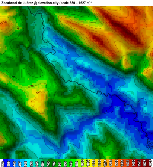
Below is the Elevation map of Zacatonal de Juárez, which displays elevation range with different colors. Scale of the first map is from 350 to 1627 m (1148 to 5338 ft) with average elevation of 786.5 meters (=2580 ft) [note 1]
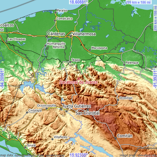
These maps also provides idea of topography and contour of this city, they are displayed at different zoom levels. More info about maps, scale and edge coordinates you can find below images.
| \ | Map #1 | Topo.Map |
| Scale [m] | 350..1627 m | × |
| Scale [ft] | 1148..5338 ft | × |
| Average | 786.5 m = 2580 ft | × |
| Width | 9.33 km = 5.8 mi | 298.6 km = 185.5 mi |
| Height | 9.33 km = 5.8 mi | 298.6 km = 185.5 mi |
| ↑Max Latitude | 17.312929° | 18.60881° |
| Latitude at center | 17.27097° | 17.27097° |
| ↓Min Latitude | 17.229001° | 15.92335° |
| ← Min Longitude | -92.843305° | -94.20561° |
| Longitude center | -92.79936° | -92.79936° |
| →Max Longitude | -92.755415° | -91.39311° |
Nearby cities:
Cities around Zacatonal de Juárez sort by population:
• Amatán elevation 807 m
11.7 km,  349°
349°
• San Andrés Duraznal 1579 m
15.5 km,  182°
182°
• San José Chapayal 1199 m
10.2 km,  288°
288°
• Oxolotán 62 m
13.2 km,  23°
23°
• La Pimienta 823 m
15 km,  164°
164°
• Ignacio Zaragoza 889 m
14.9 km,  278°
278°
• Arroyo Grande 1758 m
11.8 km,  221°
221°
• Reforma y Planada 431 m
14.7 km,  331°
331°
• La Competencia 425 m
5.9 km,  131°
131°
• José María Morelos y Pavón 992 m
10.8 km,  107°
107°
• Aurora Ermita 1508 m
8.8 km,  243°
243°
• Chapallal Grande 781 m
15.7 km, 280°
Multilingual:
 En español:
Zacatonal de Juárez elevación 586 m.
 En France:
Zacatonal de Juárez élévation 586 m.
 Auf Deutsch:
Zacatonal de Juárez höhe über dem Meeresspiegel ist 586 m.
 На русском:
Zacatonal de Juárez высота над уровнем моря 586 м
Sources and notes:
- [note 1] Map square and city borders are not equal. Map elevation data is calculated only from area inside that square.
- [src 1] Elevation data from geonames database provided with same terms of usage.
- [src 2] The elevation map of Zacatonal de Juárez is generated using elevation data from NASA's 3 arcsec (90m) resolution SRTM data.
- [src 3] Base (background) map © OpenStreetMap contributors tiles are generated by Geofabrik and OpenTopoMap.
Copyright & License:
This Zacatonal de Juárez Elevation Map is licensed under CC BY-SA. You may reuse any part from this page, if you give a proper credit by linking to this URL:
 More info on terms of use page.