José María Morelos y Pavón elevation
José María Morelos y Pavón (Chiapas, Huitiupán), Mexico elevation is 992 meters and José María Morelos y Pavón elevation in feet is 3255 ft above sea level [src 1]. José María Morelos y Pavón is a populated place (feature code) with elevation that is 322 meters (1056 ft) smaller than average city elevation in Mexico.
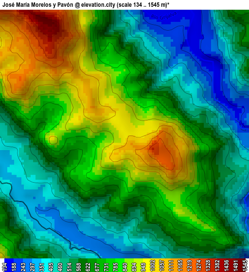
Below is the Elevation map of José María Morelos y Pavón, which displays elevation range with different colors. Scale of the first map is from 134 to 1545 m (440 to 5069 ft) with average elevation of 657.5 meters (=2157 ft) [note 1]
These maps also provides idea of topography and contour of this city, they are displayed at different zoom levels. More info about maps, scale and edge coordinates you can find below images.
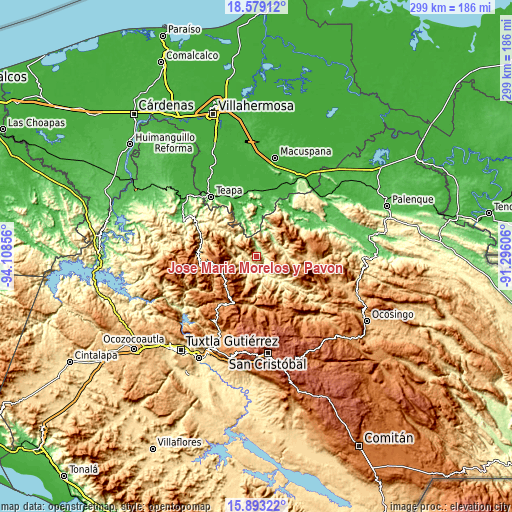
| \ | Map #1 | Topo.Map |
| Scale [m] | 134..1545 m | × |
| Scale [ft] | 440..5069 ft | × |
| Average | 657.5 m = 2157 ft | × |
| Width | 9.33 km = 5.8 mi | 298.6 km = 185.5 mi |
| Height | 9.33 km = 5.8 mi | 298.7 km = 185.6 mi |
| ↑Max Latitude | 17.283016° | 18.57912° |
| Latitude at center | 17.24105° | 17.24105° |
| ↓Min Latitude | 17.199075° | 15.89322° |
| ← Min Longitude | -92.746255° | -94.10856° |
| Longitude center | -92.70231° | -92.70231° |
| →Max Longitude | -92.658365° | -91.29606° |
Nearby cities:
Cities around José María Morelos y Pavón sort by population:
• Simojovel de Allende elevation 700 m
11.3 km,  186°
186°
• Huitiupán 306 m
7.8 km,  167°
167°
• Los Naranjos 1077 m
9.1 km,  73°
73°
• Moyos 603 m
14.6 km,  26°
26°
• Oxolotán 62 m
16.2 km,  342°
342°
• La Pimienta 823 m
12.8 km,  209°
209°
• El Jardín 903 m
13.7 km,  127°
127°
• Zacatonal de Juárez 586 m
10.8 km,  287°
287°
• El Calvario 980 m
15.7 km,  99°
99°
• Majastic 813 m
9.5 km,  55°
55°
• La Competencia 425 m
5.9 km,  264°
264°
• El Paraíso 537 m
15.4 km,  87°
87°
Multilingual:
 En español:
José María Morelos y Pavón elevación 992 m.
 En France:
José María Morelos y Pavón élévation 992 m.
 Auf Deutsch:
José María Morelos y Pavón höhe über dem Meeresspiegel ist 992 m.
 На русском:
José María Morelos y Pavón высота над уровнем моря 992 м
Sources and notes:
- [note 1] Map square and city borders are not equal. Map elevation data is calculated only from area inside that square.
- [src 1] Elevation data from geonames database provided with same terms of usage.
- [src 2] The elevation map of José María Morelos y Pavón is generated using elevation data from NASA's 3 arcsec (90m) resolution SRTM data.
- [src 3] Base (background) map © OpenStreetMap contributors tiles are generated by Geofabrik and OpenTopoMap.
Copyright & License:
This José María Morelos y Pavón Elevation Map is licensed under CC BY-SA. You may reuse any part from this page, if you give a proper credit by linking to this URL:
 More info on terms of use page.