Villa Vicente Guerrero elevation
Villa Vicente Guerrero (Tlaxcala, San Pablo del Monte), Mexico elevation is 2305 meters and Villa Vicente Guerrero elevation in feet is 7562 ft above sea level [src 1]. Villa Vicente Guerrero is a seat of a second-order administrative division (feature code) with elevation that is 991 meters (3251 ft) bigger than average city elevation in Mexico.
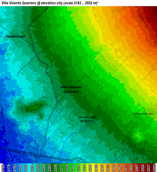
Below is the Elevation map of Villa Vicente Guerrero, which displays elevation range with different colors. Scale of the first map is from 2163 to 2552 m (7096 to 8373 ft) with average elevation of 2305.7 meters (=7565 ft) [note 1]
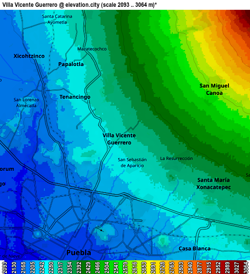
These maps also provides idea of topography and contour of this city, they are displayed at different zoom levels. More info about maps, scale and edge coordinates you can find below images.
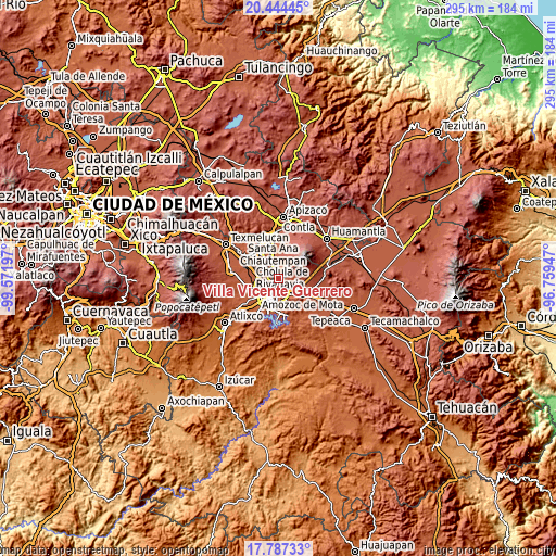
| \ | Map #1 | Map #2 | Topo.Map |
| Scale [m] | 2163..2552 m | 2093..3064 m | × |
| Scale [ft] | 7096..8373 ft | 6867..10052 ft | × |
| Average | 2305.7 m = 7565 ft | 2324.1 m = 7625 ft | × |
| Width | 9.23 km = 5.7 mi | 18.47 km = 11.5 mi | 295.4 km = 183.6 mi |
| Height | 9.23 km = 5.7 mi | 18.47 km = 11.5 mi | 295.5 km = 183.6 mi |
| ↑Max Latitude | 19.162746° | 19.204251° | 20.44445° |
| Latitude at center | 19.12123° | 19.12123° | 19.12123° |
| ↓Min Latitude | 19.079704° | 19.038168° | 17.78733° |
| ← Min Longitude | -98.209665° | -98.253611° | -99.57197° |
| Longitude center | -98.16572° | -98.16572° | -98.16572° |
| →Max Longitude | -98.121775° | -98.077829° | -96.75947° |
Nearby cities:
Cities around Villa Vicente Guerrero sort by population:
• Papalotla elevation 2251 m
6.6 km,  322°
322°
• San Miguel Canoa 2596 m
7.4 km,  62°
62°
• Santa María Xonacatepec 2351 m
7.4 km,  118°
118°
• Almecatla 2224 m
7.8 km,  288°
288°
• Xicohtzinco 2202 m
9.2 km,  309°
309°
• Tenancingo 2267 m
4.7 km, 307°
• Mazatecochco 2323 m
6.8 km,  340°
340°
• La Resurrección 2346 m
4.3 km, 118°
• San Isidro Buen Suceso 2618 m
7.4 km, 59°
• San Sebastián de Aparicio 2277 m
2.1 km,  165°
165°
• San Marcos Contla 2307 m
9.4 km, 337°
• Primero de Mayo 2337 m
8.4 km, 121°
Multilingual:
 En español:
Villa Vicente Guerrero elevación 2305 m.
 En France:
Villa Vicente Guerrero élévation 2305 m.
 Auf Deutsch:
Villa Vicente Guerrero höhe über dem Meeresspiegel ist 2305 m.
 На русском:
Villa Vicente Guerrero высота над уровнем моря 2305 м
Sources and notes:
- [note 1] Map square and city borders are not equal. Map elevation data is calculated only from area inside that square.
- [src 1] Elevation data from geonames database provided with same terms of usage.
- [src 2] The elevation map of Villa Vicente Guerrero is generated using elevation data from NASA's 3 arcsec (90m) resolution SRTM data.
- [src 3] Base (background) map © OpenStreetMap contributors tiles are generated by Geofabrik and OpenTopoMap.
Copyright & License:
This Villa Vicente Guerrero Elevation Map is licensed under CC BY-SA. You may reuse any part from this page, if you give a proper credit by linking to this URL:
 More info on terms of use page.