Benito Juárez elevation
Benito Juárez (Tlaxcala), Mexico elevation is 2539 meters and Benito Juárez elevation in feet is 8330 ft above sea level [src 1]. Benito Juárez is a seat of a second-order administrative division (feature code) with elevation that is 1225 meters (4019 ft) bigger than average city elevation in Mexico.
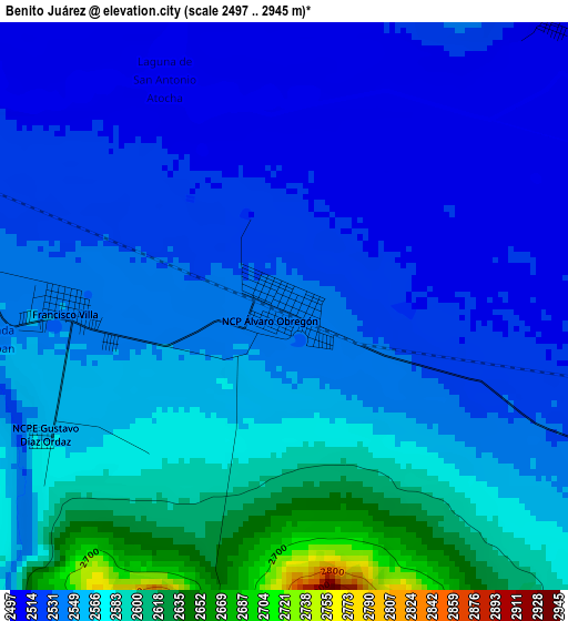
Below is the Elevation map of Benito Juárez, which displays elevation range with different colors. Scale of the first map is from 2497 to 2945 m (8192 to 9662 ft) with average elevation of 2549.9 meters (=8366 ft) [note 1]
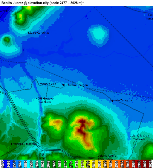
These maps also provides idea of topography and contour of this city, they are displayed at different zoom levels. More info about maps, scale and edge coordinates you can find below images.
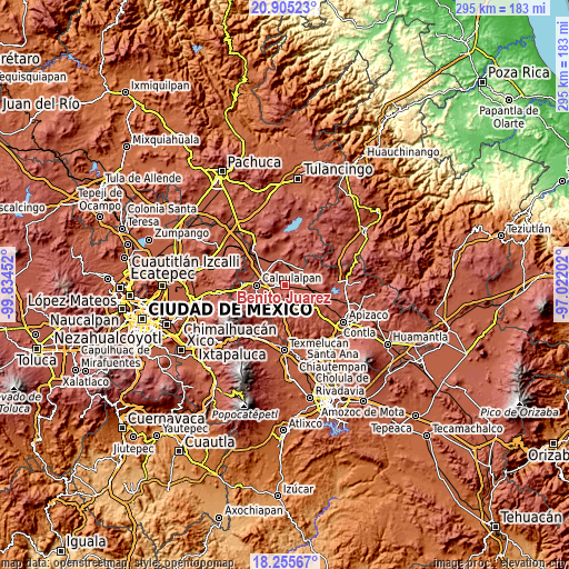
| \ | Map #1 | Map #2 | Topo.Map |
| Scale [m] | 2497..2945 m | 2477..3028 m | × |
| Scale [ft] | 8192..9662 ft | 8127..9934 ft | × |
| Average | 2549.9 m = 8366 ft | 2569.4 m = 8430 ft | × |
| Width | 9.21 km = 5.7 mi | 18.41 km = 11.4 mi | 294.6 km = 183.1 mi |
| Height | 9.21 km = 5.7 mi | 18.41 km = 11.4 mi | 294.6 km = 183.1 mi |
| ↑Max Latitude | 19.627297° | 19.668684° | 20.90523° |
| Latitude at center | 19.5859° | 19.5859° | 19.5859° |
| ↓Min Latitude | 19.544492° | 19.503073° | 18.25567° |
| ← Min Longitude | -98.472215° | -98.516161° | -99.83452° |
| Longitude center | -98.42827° | -98.42827° | -98.42827° |
| →Max Longitude | -98.384325° | -98.340379° | -97.02202° |
Nearby cities:
Cities around Benito Juárez sort by population:
• Apan elevation 2489 m
14.1 km,  350°
350°
• Almoloya 2536 m
13.4 km,  11°
11°
• Sanctórum 2742 m
11.2 km,  203°
203°
• Francisco Villa 2546 m
3.6 km,  270°
270°
• Españita 2653 m
13.7 km,  178°
178°
• Lázaro Cárdenas 2530 m
7.6 km,  323°
323°
• Chimalpa y Tlalayote 2483 m
12.5 km, 315°
• Unión Ejidal Tierra y Libertad 2516 m
12.4 km,  50°
50°
• Ignacio Zaragoza 2524 m
5.6 km,  109°
109°
• Francisco I. Madero 2634 m
9.7 km,  222°
222°
• Zotoluca 2513 m
9.1 km,  287°
287°
• San Lorenzo Sóltepec 2536 m
12.2 km,  80°
80°
Multilingual:
 En español:
Benito Juárez elevación 2539 m.
 En France:
Benito Juárez élévation 2539 m.
 Auf Deutsch:
Benito Juárez höhe über dem Meeresspiegel ist 2539 m.

Sources and notes:
- [note 1] Map square and city borders are not equal. Map elevation data is calculated only from area inside that square.
- [src 1] Elevation data from geonames database provided with same terms of usage.
- [src 2] The elevation map of Benito Juárez is generated using elevation data from NASA's 3 arcsec (90m) resolution SRTM data.
- [src 3] Base (background) map © OpenStreetMap contributors tiles are generated by Geofabrik and OpenTopoMap.
Copyright & License:
This Benito Juárez Elevation Map is licensed under CC BY-SA. You may reuse any part from this page, if you give a proper credit by linking to this URL:
 More info on terms of use page.