Apan elevation
Apan (Hidalgo), Mexico elevation is 2489 meters and Apan elevation in feet is 8166 ft above sea level [src 1]. Apan is a seat of a second-order administrative division (feature code) with elevation that is 1175 meters (3855 ft) bigger than average city elevation in Mexico.
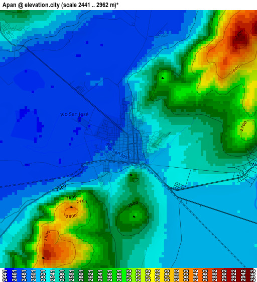
Below is the Elevation map of Apan, which displays elevation range with different colors. Scale of the first map is from 2441 to 2962 m (8009 to 9718 ft) with average elevation of 2556.4 meters (=8387 ft) [note 1]
These maps also provides idea of topography and contour of this city, they are displayed at different zoom levels. More info about maps, scale and edge coordinates you can find below images.
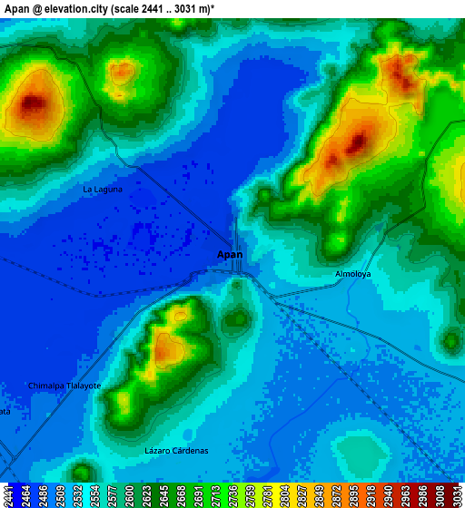
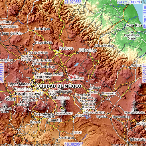
| \ | Map #1 | Map #2 | Topo.Map |
| Scale [m] | 2441..2962 m | 2441..3031 m | × |
| Scale [ft] | 8009..9718 ft | 8009..9944 ft | × |
| Average | 2556.4 m = 8387 ft | 2575.3 m = 8449 ft | × |
| Width | 9.2 km = 5.7 mi | 18.4 km = 11.4 mi | 294.4 km = 182.9 mi |
| Height | 9.2 km = 5.7 mi | 18.4 km = 11.4 mi | 294.4 km = 182.9 mi |
| ↑Max Latitude | 19.752645° | 19.793999° | 21.02955° |
| Latitude at center | 19.71128° | 19.71128° | 19.71128° |
| ↓Min Latitude | 19.669904° | 19.628518° | 18.38205° |
| ← Min Longitude | -98.494805° | -98.538751° | -99.85711° |
| Longitude center | -98.45086° | -98.45086° | -98.45086° |
| →Max Longitude | -98.406915° | -98.362969° | -97.04461° |
Nearby cities:
Cities around Apan sort by population:
• Tepeapulco elevation 2504 m
13.7 km,  308°
308°
• Emiliano Zapata 2496 m
11.7 km,  237°
237°
• Almoloya 2536 m
5 km,  98°
98°
• Lázaro Cárdenas 2530 m
8.2 km,  195°
195°
• Chimalpa y Tlalayote 2483 m
8.2 km,  231°
231°
• Unión Ejidal Tierra y Libertad 2516 m
13.3 km,  116°
116°
• Santa Bárbara 2510 m
13.3 km,  248°
248°
• La Laguna 2490 m
5.7 km,  296°
296°
• Santa Clara 2493 m
13.4 km,  264°
264°
• José María Morelos (San José) 2504 m
13.5 km, 256°
• Los Cides 2515 m
12.6 km,  325°
325°
• Zotoluca 2513 m
12.8 km,  209°
209°
Multilingual:
 En español:
Apan elevación 2489 m.
 En France:
Apan élévation 2489 m.


Sources and notes:
- [note 1] Map square and city borders are not equal. Map elevation data is calculated only from area inside that square.
- [src 1] Elevation data from geonames database provided with same terms of usage.
- [src 2] The elevation map of Apan is generated using elevation data from NASA's 3 arcsec (90m) resolution SRTM data.
- [src 3] Base (background) map © OpenStreetMap contributors tiles are generated by Geofabrik and OpenTopoMap.
Copyright & License:
This Apan Elevation Map is licensed under CC BY-SA. You may reuse any part from this page, if you give a proper credit by linking to this URL:
 More info on terms of use page.