Irolo elevation
Irolo (Hidalgo, Tepeapulco), Mexico elevation is 2456 meters and Irolo elevation in feet is 8058 ft above sea level [src 1]. Irolo is a populated place (feature code) with elevation that is 1142 meters (3747 ft) bigger than average city elevation in Mexico.
Below is the Elevation map of Irolo, which displays elevation range with different colors. Scale of the first map is from 2438 to 3015 m (7999 to 9892 ft) with average elevation of 2509.4 meters (=8233 ft) [note 1]
These maps also provides idea of topography and contour of this city, they are displayed at different zoom levels. More info about maps, scale and edge coordinates you can find below images.
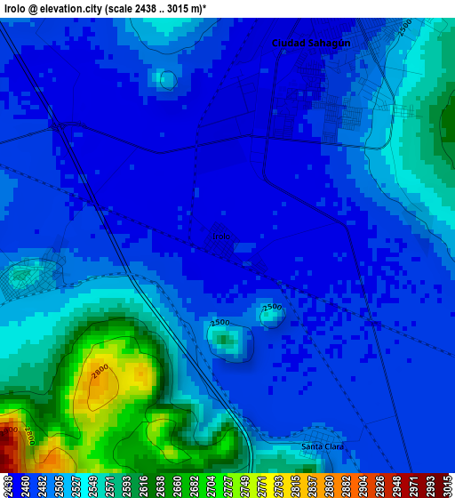
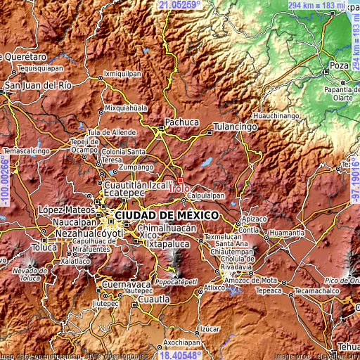
| \ | Map #1 | Topo.Map |
| Scale [m] | 2438..3015 m | × |
| Scale [ft] | 7999..9892 ft | × |
| Average | 2509.4 m = 8233 ft | × |
| Width | 9.2 km = 5.7 mi | 294.3 km = 182.9 mi |
| Height | 9.2 km = 5.7 mi | 294.4 km = 182.9 mi |
| ↑Max Latitude | 19.775879° | 21.05259° |
| Latitude at center | 19.73452° | 19.73452° |
| ↓Min Latitude | 19.69315° | 18.40548° |
| ← Min Longitude | -98.640355° | -100.00266° |
| Longitude center | -98.59641° | -98.59641° |
| →Max Longitude | -98.552465° | -97.19016° |
Nearby cities:
Cities around Irolo sort by population:
• Ciudad Sahagun elevation 2455 m
5.1 km,  26°
26°
• Tepeapulco 2504 m
7.5 km,  37°
37°
• Emiliano Zapata 2496 m
10.4 km,  148°
148°
• Tlanalapa 2457 m
9.4 km,  355°
355°
• Jaltepec 2539 m
4 km,  262°
262°
• Chimalpa y Tlalayote 2483 m
11.7 km,  131°
131°
• Santa Bárbara 2510 m
8.1 km,  159°
159°
• La Laguna 2490 m
10.1 km,  90°
90°
• Santa Clara 2493 m
4.4 km, 153°
• José María Morelos (San José) 2504 m
6.2 km, 160°
• Los Cides 2515 m
11.2 km,  46°
46°
• San Isidro 2468 m
6.1 km,  4°
4°
Multilingual:
 En español:
Irolo elevación 2456 m.
 En France:
Irolo élévation 2456 m.


Sources and notes:
- [note 1] Map square and city borders are not equal. Map elevation data is calculated only from area inside that square.
- [src 1] Elevation data from geonames database provided with same terms of usage.
- [src 2] The elevation map of Irolo is generated using elevation data from NASA's 3 arcsec (90m) resolution SRTM data.
- [src 3] Base (background) map © OpenStreetMap contributors tiles are generated by Geofabrik and OpenTopoMap.
Copyright & License:
This Irolo Elevation Map is licensed under CC BY-SA. You may reuse any part from this page, if you give a proper credit by linking to this URL:
 More info on terms of use page.