Cañada elevation
Cañada (Hidalgo, Mixquiahuala de Juárez), Mexico elevation is 2026 meters and Cañada elevation in feet is 6647 ft above sea level [src 1]. Cañada is a populated place (feature code) with elevation that is 712 meters (2336 ft) bigger than average city elevation in Mexico.
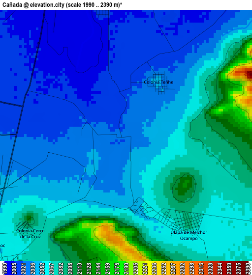
Below is the Elevation map of Cañada, which displays elevation range with different colors. Scale of the first map is from 1990 to 2390 m (6529 to 7841 ft) with average elevation of 2052.8 meters (=6735 ft) [note 1]
These maps also provides idea of topography and contour of this city, they are displayed at different zoom levels. More info about maps, scale and edge coordinates you can find below images.
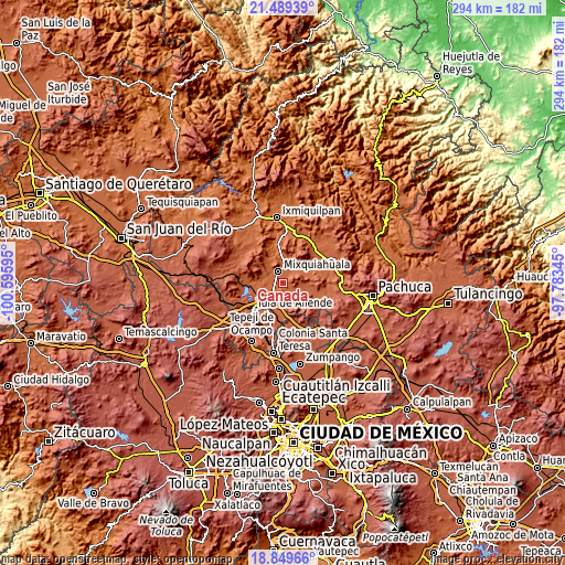
| \ | Map #1 | Topo.Map |
| Scale [m] | 1990..2390 m | × |
| Scale [ft] | 6529..7841 ft | × |
| Average | 2052.8 m = 6735 ft | × |
| Width | 9.17 km = 5.7 mi | 293.5 km = 182.4 mi |
| Height | 9.17 km = 5.7 mi | 293.5 km = 182.4 mi |
| ↑Max Latitude | 20.216353° | 21.48939° |
| Latitude at center | 20.17511° | 20.17511° |
| ↓Min Latitude | 20.133856° | 18.84966° |
| ← Min Longitude | -99.233645° | -100.59595° |
| Longitude center | -99.1897° | -99.1897° |
| →Max Longitude | -99.145755° | -97.78345° |
Nearby cities:
Cities around Cañada sort by population:
• Mixquiahuala de Juarez elevation 2002 m
6.6 km,  337°
337°
• Progreso de Alvaro Obregon 1998 m
8.2 km,  359°
359°
• Tlahuelilpan 2063 m
6.6 km,  221°
221°
• Presas 2043 m
6.8 km,  255°
255°
• Teltipán de Juárez 2114 m
6.8 km,  190°
190°
• Mangas 2005 m
6.2 km,  281°
281°
• Colonia Teñhe 2040 m
2.3 km,  30°
30°
• Munitepec de Madero 2129 m
5.3 km, 191°
• Colonia Morelos (El Nueve) 2019 m
7.5 km,  42°
42°
• Palmillas 2011 m
4.9 km,  349°
349°
• La Cruz 2022 m
5.4 km,  271°
271°
• Motovatha 2012 m
1.9 km,  300°
300°
Multilingual:
 En español:
Cañada elevación 2026 m.
 En France:
Cañada élévation 2026 m.


Sources and notes:
- [note 1] Map square and city borders are not equal. Map elevation data is calculated only from area inside that square.
- [src 1] Elevation data from geonames database provided with same terms of usage.
- [src 2] The elevation map of Cañada is generated using elevation data from NASA's 3 arcsec (90m) resolution SRTM data.
- [src 3] Base (background) map © OpenStreetMap contributors tiles are generated by Geofabrik and OpenTopoMap.
Copyright & License:
This Cañada Elevation Map is licensed under CC BY-SA. You may reuse any part from this page, if you give a proper credit by linking to this URL:
 More info on terms of use page.