Tlahuelilpan elevation
Tlahuelilpan (Hidalgo), Mexico elevation is 2063 meters and Tlahuelilpan elevation in feet is 6768 ft above sea level [src 1]. Tlahuelilpan is a populated place (feature code) with elevation that is 749 meters (2457 ft) bigger than average city elevation in Mexico.
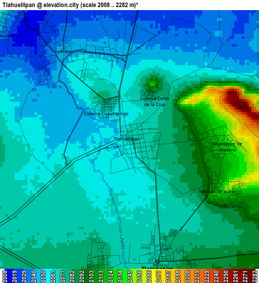
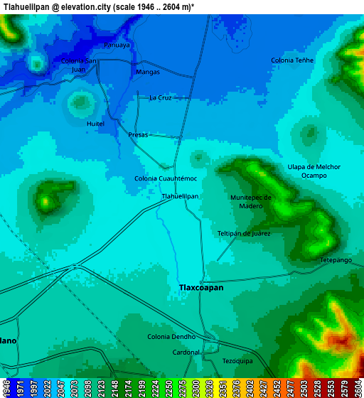
Below is the Elevation map of Tlahuelilpan, which displays elevation range with different colors. Scale of the first map is from 2008 to 2282 m (6588 to 7487 ft) with average elevation of 2068.2 meters (=6785 ft) [note 1]
These maps also provides idea of topography and contour of this city, they are displayed at different zoom levels. More info about maps, scale and edge coordinates you can find below images.
| \ | Map #1 | Map #2 | Topo.Map |
| Scale [m] | 2008..2282 m | 1946..2604 m | × |
| Scale [ft] | 6588..7487 ft | 6385..8543 ft | × |
| Average | 2068.2 m = 6785 ft | 2081 m = 6827 ft | × |
| Width | 9.18 km = 5.7 mi | 18.35 km = 11.4 mi | 293.6 km = 182.4 mi |
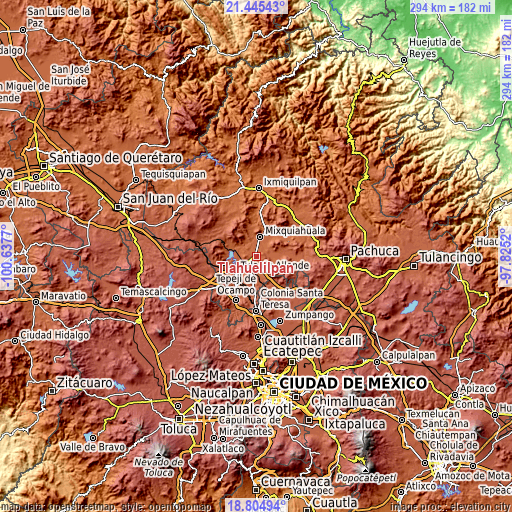
| Height | 9.18 km = 5.7 mi | 18.35 km = 11.4 mi | 293.6 km = 182.4 mi |
| ↑Max Latitude | 20.172015° | 20.21326° | 21.44543° |
| Latitude at center | 20.13076° | 20.13076° | 20.13076° |
| ↓Min Latitude | 20.089494° | 20.048217° | 18.80494° |
| ← Min Longitude | -99.275395° | -99.319341° | -100.6377° |
| Longitude center | -99.23145° | -99.23145° | -99.23145° |
| →Max Longitude | -99.187505° | -99.143559° | -97.8252° |
Nearby cities:
Cities around Tlahuelilpan sort by population:
• Tlaxcoapan elevation 2073 m
4.5 km,  165°
165°
• Doxey 2081 m
4.5 km,  196°
196°
• Presas 2043 m
3.9 km,  325°
325°
• Huitel 2049 m
6.4 km,  309°
309°
• Teltipán de Juárez 2114 m
3.6 km,  118°
118°
• Mangas 2005 m
6.4 km,  344°
344°
• Munitepec de Madero 2129 m
3.3 km,  94°
94°
• Tlalminulpa 2094 m
6.3 km, 171°
• La Cruz 2022 m
5.1 km,  348°
348°
• Cañada 2026 m
6.6 km,  41°
41°
• Teocalco 2078 m
7.3 km,  227°
227°
• Motovatha 2012 m
6.5 km,  24°
24°
Multilingual:
 En español:
Tlahuelilpan elevación 2063 m.
 En France:
Tlahuelilpan élévation 2063 m.
 Auf Deutsch:
Tlahuelilpan höhe über dem Meeresspiegel ist 2063 m.

Sources and notes:
- [note 1] Map square and city borders are not equal. Map elevation data is calculated only from area inside that square.
- [src 1] Elevation data from geonames database provided with same terms of usage.
- [src 2] The elevation map of Tlahuelilpan is generated using elevation data from NASA's 3 arcsec (90m) resolution SRTM data.
- [src 3] Base (background) map © OpenStreetMap contributors tiles are generated by Geofabrik and OpenTopoMap.
Copyright & License:
This Tlahuelilpan Elevation Map is licensed under CC BY-SA. You may reuse any part from this page, if you give a proper credit by linking to this URL:
 More info on terms of use page.