Huitel elevation
Huitel (Hidalgo, Tezontepec de Aldama), Mexico elevation is 2049 meters and Huitel elevation in feet is 6722 ft above sea level [src 1]. Huitel is a populated place (feature code) with elevation that is 735 meters (2411 ft) bigger than average city elevation in Mexico.
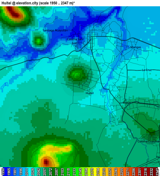
Below is the Elevation map of Huitel, which displays elevation range with different colors. Scale of the first map is from 1950 to 2347 m (6398 to 7700 ft) with average elevation of 2038.1 meters (=6687 ft) [note 1]
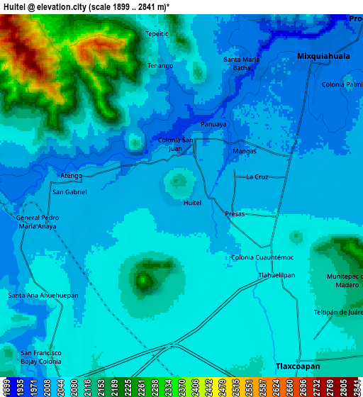
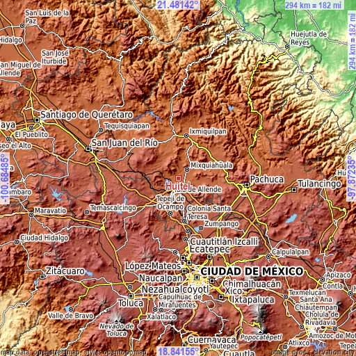
These maps also provides idea of topography and contour of this city, they are displayed at different zoom levels. More info about maps, scale and edge coordinates you can find below images.
| \ | Map #1 | Map #2 | Topo.Map |
| Scale [m] | 1950..2347 m | 1899..2841 m | × |
| Scale [ft] | 6398..7700 ft | 6230..9321 ft | × |
| Average | 2038.1 m = 6687 ft | 2076.9 m = 6814 ft | × |
| Width | 9.17 km = 5.7 mi | 18.35 km = 11.4 mi | 293.5 km = 182.4 mi |
| Height | 9.17 km = 5.7 mi | 18.35 km = 11.4 mi | 293.5 km = 182.4 mi |
| ↑Max Latitude | 20.208316° | 20.24955° | 21.48142° |
| Latitude at center | 20.16707° | 20.16707° | 20.16707° |
| ↓Min Latitude | 20.125813° | 20.084546° | 18.84155° |
| ← Min Longitude | -99.322545° | -99.366491° | -100.68485° |
| Longitude center | -99.2786° | -99.2786° | -99.2786° |
| →Max Longitude | -99.234655° | -99.190709° | -97.87235° |
Nearby cities:
Cities around Huitel sort by population:
• Tlahuelilpan elevation 2063 m
6.4 km,  129°
129°
• Presas 2043 m
2.9 km,  107°
107°
• Tezontepec de Aldama 2006 m
2.7 km,  9°
9°
• Panuaya 2008 m
3.2 km, 14°
• Mangas 2005 m
3.9 km,  55°
55°
• Atengo 2034 m
5.1 km,  280°
280°
• San Gabriel 2032 m
5.9 km,  274°
274°
• San Juan Achichilco 2025 m
4 km,  288°
288°
• La Cruz 2022 m
4 km,  75°
75°
• Santiago Acayutlán 1986 m
3.8 km,  332°
332°
• Tenango 2041 m
6.8 km,  349°
349°
• Colonia San Juan 2006 m
2.6 km, 350°
Multilingual:
 En español:
Huitel elevación 2049 m.
 En France:
Huitel élévation 2049 m.


Sources and notes:
- [note 1] Map square and city borders are not equal. Map elevation data is calculated only from area inside that square.
- [src 1] Elevation data from geonames database provided with same terms of usage.
- [src 2] The elevation map of Huitel is generated using elevation data from NASA's 3 arcsec (90m) resolution SRTM data.
- [src 3] Base (background) map © OpenStreetMap contributors tiles are generated by Geofabrik and OpenTopoMap.
Copyright & License:
This Huitel Elevation Map is licensed under CC BY-SA. You may reuse any part from this page, if you give a proper credit by linking to this URL:
 More info on terms of use page.