Mixquiahuala de Juarez elevation
Mixquiahuala de Juarez (Hidalgo, Mixquiahuala de Juárez), Mexico elevation is 2002 meters and Mixquiahuala de Juarez elevation in feet is 6568 ft above sea level [src 1]. Mixquiahuala de Juarez is a populated place (feature code) with elevation that is 688 meters (2257 ft) bigger than average city elevation in Mexico.
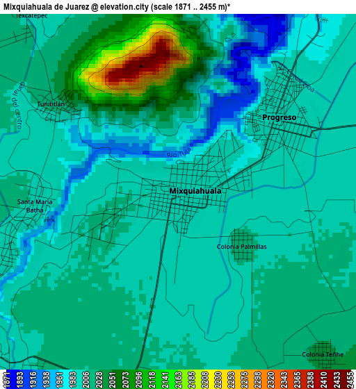
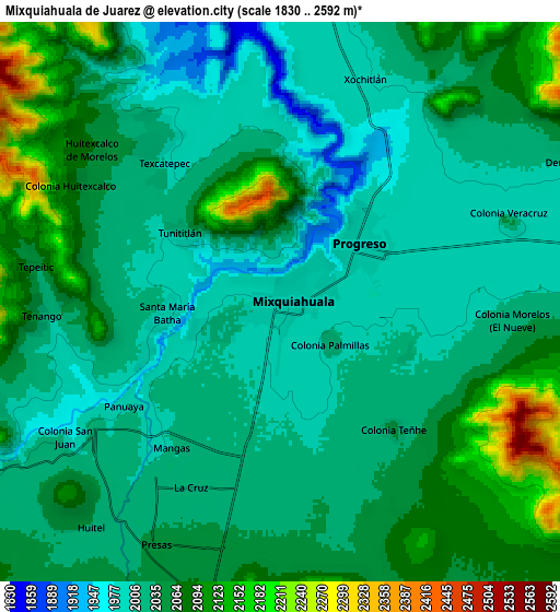
Below is the Elevation map of Mixquiahuala de Juarez, which displays elevation range with different colors. Scale of the first map is from 1871 to 2455 m (6138 to 8054 ft) with average elevation of 2011 meters (=6598 ft) [note 1]
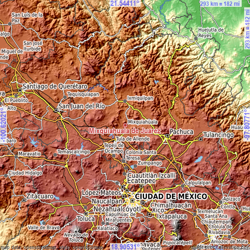
These maps also provides idea of topography and contour of this city, they are displayed at different zoom levels. More info about maps, scale and edge coordinates you can find below images.
| \ | Map #1 | Map #2 | Topo.Map |
| Scale [m] | 1871..2455 m | 1830..2592 m | × |
| Scale [ft] | 6138..8054 ft | 6004..8504 ft | × |
| Average | 2011 m = 6598 ft | 2042.2 m = 6700 ft | × |
| Width | 9.17 km = 5.7 mi | 18.34 km = 11.4 mi | 293.4 km = 182.3 mi |
| Height | 9.17 km = 5.7 mi | 18.34 km = 11.4 mi | 293.4 km = 182.3 mi |
| ↑Max Latitude | 20.271539° | 20.312757° | 21.54411° |
| Latitude at center | 20.23031° | 20.23031° | 20.23031° |
| ↓Min Latitude | 20.18907° | 20.147819° | 18.90531° |
| ← Min Longitude | -99.257905° | -99.301851° | -100.62021° |
| Longitude center | -99.21396° | -99.21396° | -99.21396° |
| →Max Longitude | -99.170015° | -99.126069° | -97.80771° |
Nearby cities:
Cities around Mixquiahuala de Juarez sort by population:
• Progreso de Alvaro Obregon elevation 1998 m
3.3 km,  49°
49°
• Panuaya 2008 m
7.1 km,  236°
236°
• Mangas 2005 m
6 km,  216°
216°
• Colonia Teñhe 2040 m
5.6 km,  138°
138°
• Tunititlán 2010 m
3.8 km,  303°
303°
• Colonia Morelos (El Nueve) 2019 m
7.6 km,  94°
94°
• Palmillas 2011 m
2.1 km,  128°
128°
• Santa María Batha 1998 m
4 km,  260°
260°
• La Cruz 2022 m
6.7 km,  205°
205°
• Texcatepec 2022 m
6.6 km,  321°
321°
• Cañada 2026 m
6.6 km,  157°
157°
• Motovatha 2012 m
5.3 km,  169°
169°
Multilingual:
 En español:
Mixquiahuala de Juarez elevación 2002 m.
 En France:
Mixquiahuala de Juarez élévation 2002 m.
 Auf Deutsch:
Mixquiahuala de Juarez höhe über dem Meeresspiegel ist 2002 m.
 На русском:
Mixquiahuala de Juarez высота над уровнем моря 2002 м
Sources and notes:
- [note 1] Map square and city borders are not equal. Map elevation data is calculated only from area inside that square.
- [src 1] Elevation data from geonames database provided with same terms of usage.
- [src 2] The elevation map of Mixquiahuala de Juarez is generated using elevation data from NASA's 3 arcsec (90m) resolution SRTM data.
- [src 3] Base (background) map © OpenStreetMap contributors tiles are generated by Geofabrik and OpenTopoMap.
Copyright & License:
This Mixquiahuala de Juarez Elevation Map is licensed under CC BY-SA. You may reuse any part from this page, if you give a proper credit by linking to this URL:
 More info on terms of use page.