Texcatepec elevation
Texcatepec (Hidalgo, Chilcuautla), Mexico elevation is 2022 meters and Texcatepec elevation in feet is 6634 ft above sea level [src 1]. Texcatepec is a populated place (feature code) with elevation that is 708 meters (2323 ft) bigger than average city elevation in Mexico.
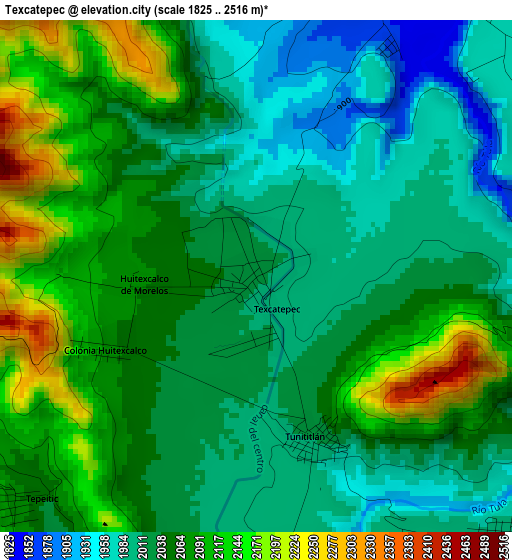
Below is the Elevation map of Texcatepec, which displays elevation range with different colors. Scale of the first map is from 1825 to 2516 m (5988 to 8255 ft) with average elevation of 2051.6 meters (=6731 ft) [note 1]
These maps also provides idea of topography and contour of this city, they are displayed at different zoom levels. More info about maps, scale and edge coordinates you can find below images.
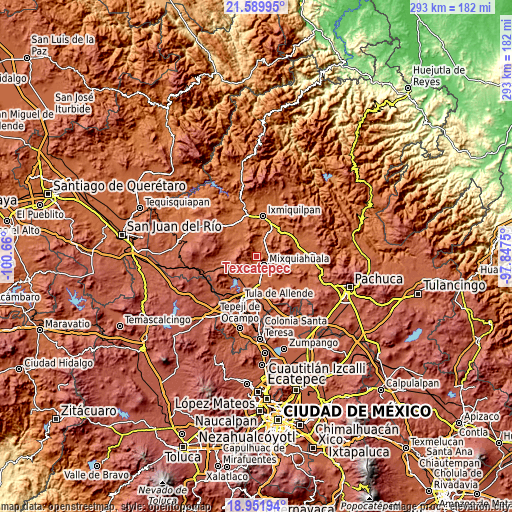
| \ | Map #1 | Topo.Map |
| Scale [m] | 1825..2516 m | × |
| Scale [ft] | 5988..8255 ft | × |
| Average | 2051.6 m = 6731 ft | × |
| Width | 9.17 km = 5.7 mi | 293.3 km = 182.2 mi |
| Height | 9.17 km = 5.7 mi | 293.3 km = 182.2 mi |
| ↑Max Latitude | 20.317767° | 21.58995° |
| Latitude at center | 20.27655° | 20.27655° |
| ↓Min Latitude | 20.235322° | 18.95194° |
| ← Min Longitude | -99.297695° | -100.66° |
| Longitude center | -99.25375° | -99.25375° |
| →Max Longitude | -99.209805° | -97.8475° |
Nearby cities:
Cities around Texcatepec sort by population:
• Mixquiahuala de Juarez elevation 2002 m
6.6 km,  141°
141°
• Progreso de Alvaro Obregon 1998 m
7.3 km,  114°
114°
• Tezontepec de Aldama 2006 m
9.8 km,  192°
192°
• Panuaya 2008 m
9.2 km, 191°
• Tunititlán 2010 m
3.2 km,  161°
161°
• Palmillas 2011 m
8.7 km, 138°
• Santa María Batha 1998 m
5.8 km,  177°
177°
• Xochitlán 1999 m
7.2 km,  72°
72°
• Tepeitic 2046 m
5.5 km,  224°
224°
• Tenango 2041 m
6.7 km, 215°
• Chilcuautla 1872 m
6.5 km,  21°
21°
• El Moreno (San Miguel Moreno) 2031 m
8.8 km, 71°
Multilingual:
 En español:
Texcatepec elevación 2022 m.
 En France:
Texcatepec élévation 2022 m.
 Auf Deutsch:
Texcatepec höhe über dem Meeresspiegel ist 2022 m.

Sources and notes:
- [note 1] Map square and city borders are not equal. Map elevation data is calculated only from area inside that square.
- [src 1] Elevation data from geonames database provided with same terms of usage.
- [src 2] The elevation map of Texcatepec is generated using elevation data from NASA's 3 arcsec (90m) resolution SRTM data.
- [src 3] Base (background) map © OpenStreetMap contributors tiles are generated by Geofabrik and OpenTopoMap.
Copyright & License:
This Texcatepec Elevation Map is licensed under CC BY-SA. You may reuse any part from this page, if you give a proper credit by linking to this URL:
 More info on terms of use page.