Teotitlán elevation
Teotitlán (Oaxaca, Teotitlán de Flores Magón), Mexico elevation is 1042 meters and Teotitlán elevation in feet is 3419 ft above sea level [src 1]. Teotitlán is a seat of a second-order administrative division (feature code) with elevation that is 272 meters (892 ft) smaller than average city elevation in Mexico.
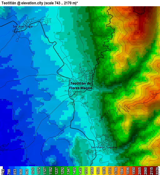
Below is the Elevation map of Teotitlán, which displays elevation range with different colors. Scale of the first map is from 743 to 2170 m (2438 to 7119 ft) with average elevation of 1150.9 meters (=3776 ft) [note 1]
These maps also provides idea of topography and contour of this city, they are displayed at different zoom levels. More info about maps, scale and edge coordinates you can find below images.
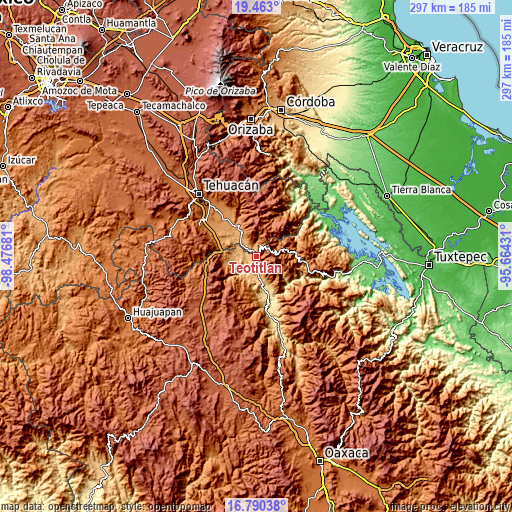
| \ | Map #1 | Map #2 | Topo.Map |
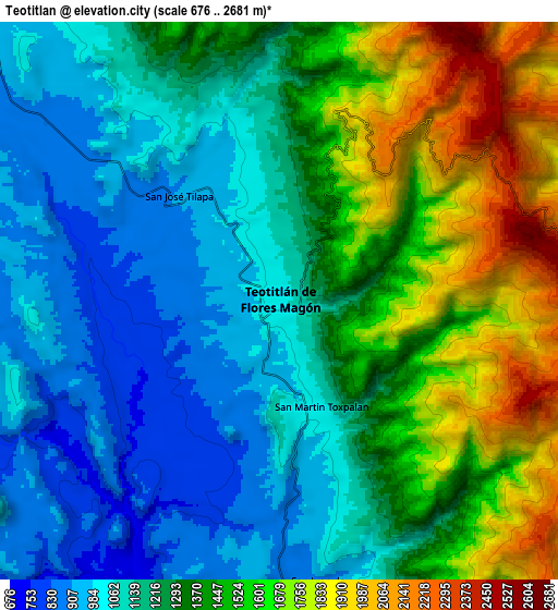
| Scale [m] | 743..2170 m | 676..2681 m | × |
| Scale [ft] | 2438..7119 ft | 2218..8796 ft | × |
| Average | 1150.9 m = 3776 ft | 1311.8 m = 4304 ft | × |
| Width | 9.29 km = 5.8 mi | 18.57 km = 11.5 mi | 297.2 km = 184.7 mi |
| Height | 9.29 km = 5.8 mi | 18.57 km = 11.5 mi | 297.2 km = 184.7 mi |
| ↑Max Latitude | 18.173548° | 18.215296° | 19.463° |
| Latitude at center | 18.13179° | 18.13179° | 18.13179° |
| ↓Min Latitude | 18.090022° | 18.048244° | 16.79038° |
| ← Min Longitude | -97.114505° | -97.158451° | -98.47681° |
| Longitude center | -97.07056° | -97.07056° | -97.07056° |
| →Max Longitude | -97.026615° | -96.982669° | -95.66431° |
Nearby cities:
Cities around Teotitlán sort by population:
• Coxcatlán elevation 1163 m
17.3 km,  330°
330°
• San José Tilapa 922 m
4.8 km,  317°
317°
• Toxpalan 1030 m
3.6 km,  159°
159°
• San Juan de los Cues 867 m
9.5 km,  173°
173°
• Tlixco 2214 m
17.5 km,  25°
25°
• San Juan Cuautla 1989 m
17.3 km,  43°
43°
• San Jerónimo Tecóatl 1861 m
17.1 km,  77°
77°
• Santa María Teopoxco 1875 m
12.8 km,  72°
72°
• San Lucas Zoquiápam 1760 m
17.5 km,  88°
88°
• San Francisco Huehuetlán 1663 m
14.8 km,  60°
60°
• Santiago Texcalcingo 2022 m
13.7 km,  51°
51°
• Nanahuatípam 801 m
5.8 km,  272°
272°
Multilingual:
 En español:
Teotitlán de Flores Magón, Teotitlán elevación 1042 m.
 En France:
Teotitlán élévation 1042 m.
 Auf Deutsch:
Teotitlán höhe über dem Meeresspiegel ist 1042 m.

Sources and notes:
- [note 1] Map square and city borders are not equal. Map elevation data is calculated only from area inside that square.
- [src 1] Elevation data from geonames database provided with same terms of usage.
- [src 2] The elevation map of Teotitlán is generated using elevation data from NASA's 3 arcsec (90m) resolution SRTM data.
- [src 3] Base (background) map © OpenStreetMap contributors tiles are generated by Geofabrik and OpenTopoMap.
Copyright & License:
This Teotitlán Elevation Map is licensed under CC BY-SA. You may reuse any part from this page, if you give a proper credit by linking to this URL:
 More info on terms of use page.