Coxcatlán elevation
Coxcatlán (Puebla), Mexico elevation is 1163 meters and Coxcatlán elevation in feet is 3816 ft above sea level [src 1]. Coxcatlán is a seat of a second-order administrative division (feature code) with elevation that is 151 meters (495 ft) smaller than average city elevation in Mexico.
Below is the Elevation map of Coxcatlán, which displays elevation range with different colors. Scale of the first map is from 912 to 2377 m (2992 to 7799 ft) with average elevation of 1270.2 meters (=4167 ft) [note 1]
These maps also provides idea of topography and contour of this city, they are displayed at different zoom levels. More info about maps, scale and edge coordinates you can find below images.
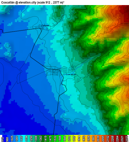
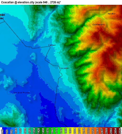
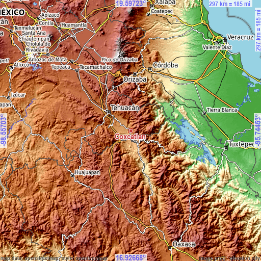
| \ | Map #1 | Map #2 | Topo.Map |
| Scale [m] | 912..2377 m | 848..2726 m | × |
| Scale [ft] | 2992..7799 ft | 2782..8944 ft | × |
| Average | 1270.2 m = 4167 ft | 1401.7 m = 4599 ft | × |
| Width | 9.28 km = 5.8 mi | 18.56 km = 11.5 mi | 296.9 km = 184.5 mi |
| Height | 9.28 km = 5.8 mi | 18.56 km = 11.5 mi | 297 km = 184.5 mi |
| ↑Max Latitude | 18.308816° | 18.350531° | 19.59723° |
| Latitude at center | 18.26709° | 18.26709° | 18.26709° |
| ↓Min Latitude | 18.225354° | 18.183609° | 16.92668° |
| ← Min Longitude | -97.194725° | -97.238671° | -98.55703° |
| Longitude center | -97.15078° | -97.15078° | -97.15078° |
| →Max Longitude | -97.106835° | -97.062889° | -95.74453° |
Nearby cities:
Cities around Coxcatlán sort by population:
• Zinacatepec elevation 1145 m
12.6 km,  306°
306°
• Miahuatlán 1121 m
14.7 km,  280°
280°
• Calipan 1140 m
3.4 km,  336°
336°
• Xitlama 1861 m
14.6 km,  73°
73°
• Zoquitlán 2145 m
16 km,  61°
61°
• San José Tilapa 922 m
12.6 km,  155°
155°
• Axuxco 977 m
7.2 km,  235°
235°
• Tlixco 2214 m
16 km,  87°
87°
• Tecoltepec 2244 m
10 km,  49°
49°
• Ocotlamanic 2359 m
8.5 km,  42°
42°
• San Jerónimo Axochitlán 1081 m
11.9 km, 276°
• Nanahuatípam 801 m
15 km,  169°
169°
Multilingual:
 En español:
Coxcatlán elevación 1163 m.
 En France:
Coxcatlán élévation 1163 m.
 Auf Deutsch:
Coxcatlán höhe über dem Meeresspiegel ist 1163 m.

Sources and notes:
- [note 1] Map square and city borders are not equal. Map elevation data is calculated only from area inside that square.
- [src 1] Elevation data from geonames database provided with same terms of usage.
- [src 2] The elevation map of Coxcatlán is generated using elevation data from NASA's 3 arcsec (90m) resolution SRTM data.
- [src 3] Base (background) map © OpenStreetMap contributors tiles are generated by Geofabrik and OpenTopoMap.
Copyright & License:
This Coxcatlán Elevation Map is licensed under CC BY-SA. You may reuse any part from this page, if you give a proper credit by linking to this URL:
 More info on terms of use page.