Tlixco elevation
Tlixco (Puebla, Coyomeapan), Mexico elevation is 2214 meters and Tlixco elevation in feet is 7264 ft above sea level [src 1]. Tlixco is a populated place (feature code) with elevation that is 900 meters (2953 ft) bigger than average city elevation in Mexico.
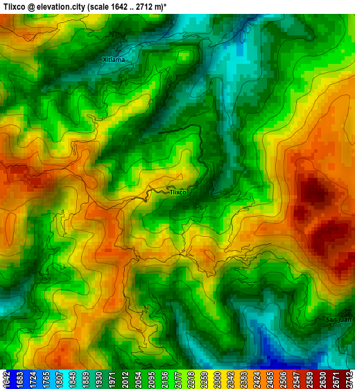
Below is the Elevation map of Tlixco, which displays elevation range with different colors. Scale of the first map is from 1642 to 2712 m (5387 to 8898 ft) with average elevation of 2168.9 meters (=7116 ft) [note 1]
These maps also provides idea of topography and contour of this city, they are displayed at different zoom levels. More info about maps, scale and edge coordinates you can find below images.
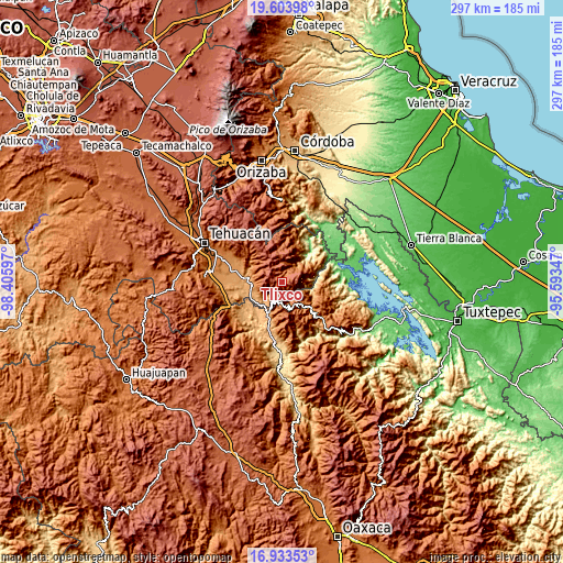
| \ | Map #1 | Topo.Map |
| Scale [m] | 1642..2712 m | × |
| Scale [ft] | 5387..8898 ft | × |
| Average | 2168.9 m = 7116 ft | × |
| Width | 9.28 km = 5.8 mi | 296.9 km = 184.5 mi |
| Height | 9.28 km = 5.8 mi | 296.9 km = 184.5 mi |
| ↑Max Latitude | 18.315614° | 19.60398° |
| Latitude at center | 18.27389° | 18.27389° |
| ↓Min Latitude | 18.232156° | 16.93353° |
| ← Min Longitude | -97.043665° | -98.40597° |
| Longitude center | -96.99972° | -96.99972° |
| →Max Longitude | -96.955775° | -95.59347° |
Nearby cities:
Cities around Tlixco sort by population:
• Xitlama elevation 1861 m
3.8 km,  330°
330°
• Acatepec 2544 m
11.6 km,  340°
340°
• Zoquitlán 2145 m
7.1 km, 344°
• Tecoltepec 2244 m
10.1 km,  304°
304°
• San Juan Cuautla 1989 m
5.6 km,  126°
126°
• Ocotlamanic 2359 m
11.6 km, 298°
• Coyomeapan 2044 m
1.1 km,  36°
36°
• San Pedro Ocopetatillo 1772 m
13.5 km,  136°
136°
• San Lorenzo Cuaunecuiltitla 1904 m
11.8 km, 129°
• Santa María Teopoxco 1875 m
12.8 km,  158°
158°
• San Francisco Huehuetlán 1663 m
10.1 km,  147°
147°
• Santiago Texcalcingo 2022 m
8 km, 155°
Multilingual:
 En español:
Tlixco elevación 2214 m.
 En France:
Tlixco élévation 2214 m.


Sources and notes:
- [note 1] Map square and city borders are not equal. Map elevation data is calculated only from area inside that square.
- [src 1] Elevation data from geonames database provided with same terms of usage.
- [src 2] The elevation map of Tlixco is generated using elevation data from NASA's 3 arcsec (90m) resolution SRTM data.
- [src 3] Base (background) map © OpenStreetMap contributors tiles are generated by Geofabrik and OpenTopoMap.
Copyright & License:
This Tlixco Elevation Map is licensed under CC BY-SA. You may reuse any part from this page, if you give a proper credit by linking to this URL:
 More info on terms of use page.