San Pedro Ocopetatillo elevation
San Pedro Ocopetatillo (Oaxaca), Mexico elevation is 1772 meters and San Pedro Ocopetatillo elevation in feet is 5814 ft above sea level [src 1]. San Pedro Ocopetatillo is a seat of a second-order administrative division (feature code) with elevation that is 458 meters (1503 ft) bigger than average city elevation in Mexico.
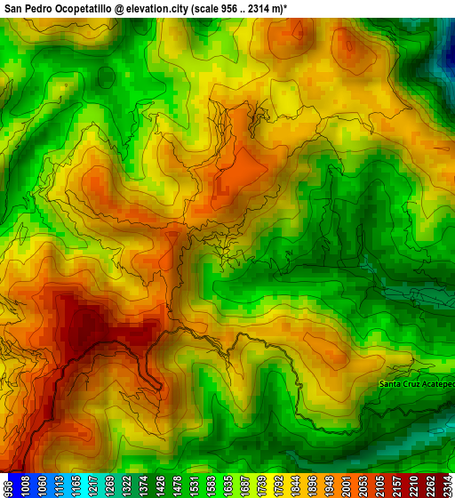
Below is the Elevation map of San Pedro Ocopetatillo, which displays elevation range with different colors. Scale of the first map is from 956 to 2314 m (3136 to 7592 ft) with average elevation of 1728.5 meters (=5671 ft) [note 1]
These maps also provides idea of topography and contour of this city, they are displayed at different zoom levels. More info about maps, scale and edge coordinates you can find below images.
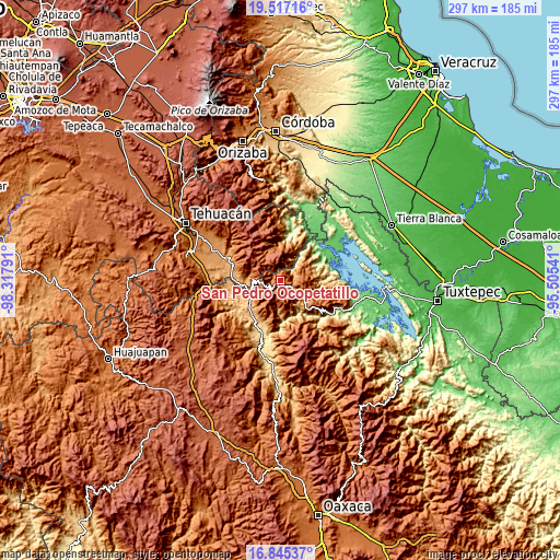
| \ | Map #1 | Topo.Map |
| Scale [m] | 956..2314 m | × |
| Scale [ft] | 3136..7592 ft | × |
| Average | 1728.5 m = 5671 ft | × |
| Width | 9.28 km = 5.8 mi | 297.1 km = 184.6 mi |
| Height | 9.28 km = 5.8 mi | 297.1 km = 184.6 mi |
| ↑Max Latitude | 18.228125° | 19.51716° |
| Latitude at center | 18.18638° | 18.18638° |
| ↓Min Latitude | 18.144625° | 16.84537° |
| ← Min Longitude | -96.955605° | -98.31791° |
| Longitude center | -96.91166° | -96.91166° |
| →Max Longitude | -96.867715° | -95.50541° |
Nearby cities:
Cities around San Pedro Ocopetatillo sort by population:
• Huautla de Jiménez elevation 1696 m
9.7 km,  129°
129°
• San Mateo Yoloxochitlán 1571 m
6.6 km,  136°
136°
• San Juan Cuautla 1989 m
8 km,  323°
323°
• Santa Cruz Acatepec 1634 m
4.6 km,  123°
123°
• Santa Cruz de Juárez 1667 m
9 km, 116°
• San Jerónimo Tecóatl 1861 m
2.2 km,  182°
182°
• Eloxochitlán de Flores Magón 1348 m
4 km,  104°
104°
• San Lorenzo Cuaunecuiltitla 1904 m
2.3 km,  356°
356°
• Santa María Teopoxco 1875 m
5.1 km,  244°
244°
• San Lucas Zoquiápam 1760 m
5.6 km,  173°
173°
• San Francisco Huehuetlán 1663 m
4 km,  287°
287°
• Santiago Texcalcingo 2022 m
6.5 km, 292°
Multilingual:
 En español:
San Pedro Ocopetatillo elevación 1772 m.
 En France:
San Pedro Ocopetatillo élévation 1772 m.
 Auf Deutsch:
San Pedro Ocopetatillo höhe über dem Meeresspiegel ist 1772 m.
 На русском:
San Pedro Ocopetatillo высота над уровнем моря 1772 м
Sources and notes:
- [note 1] Map square and city borders are not equal. Map elevation data is calculated only from area inside that square.
- [src 1] Elevation data from geonames database provided with same terms of usage.
- [src 2] The elevation map of San Pedro Ocopetatillo is generated using elevation data from NASA's 3 arcsec (90m) resolution SRTM data.
- [src 3] Base (background) map © OpenStreetMap contributors tiles are generated by Geofabrik and OpenTopoMap.
Copyright & License:
This San Pedro Ocopetatillo Elevation Map is licensed under CC BY-SA. You may reuse any part from this page, if you give a proper credit by linking to this URL:
 More info on terms of use page.