Santa Cruz Yucucani elevation
Santa Cruz Yucucani (Guerrero, Tlacoachistlahuaca), Mexico elevation is 1381 meters and Santa Cruz Yucucani elevation in feet is 4531 ft above sea level [src 1]. Santa Cruz Yucucani is a populated place (feature code) with elevation that is 67 meters (220 ft) bigger than average city elevation in Mexico.
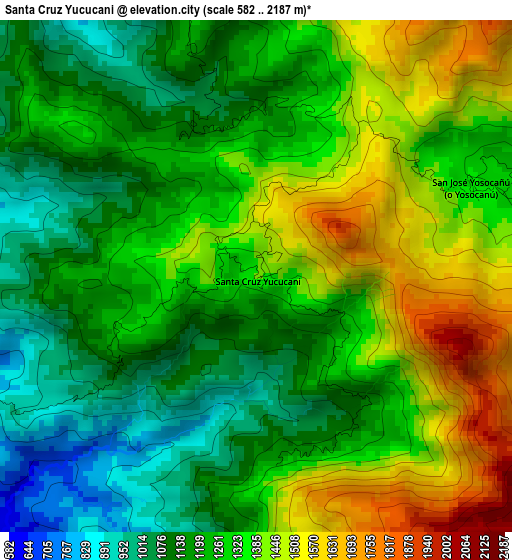
Below is the Elevation map of Santa Cruz Yucucani, which displays elevation range with different colors. Scale of the first map is from 582 to 2187 m (1909 to 7175 ft) with average elevation of 1276.7 meters (=4189 ft) [note 1]
These maps also provides idea of topography and contour of this city, they are displayed at different zoom levels. More info about maps, scale and edge coordinates you can find below images.
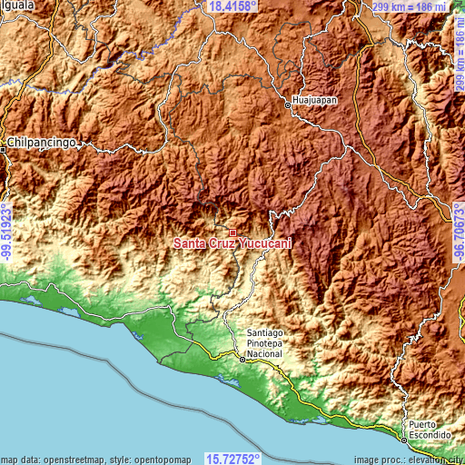
| \ | Map #1 | Topo.Map |
| Scale [m] | 582..2187 m | × |
| Scale [ft] | 1909..7175 ft | × |
| Average | 1276.7 m = 4189 ft | × |
| Width | 9.34 km = 5.8 mi | 298.9 km = 185.7 mi |
| Height | 9.34 km = 5.8 mi | 298.9 km = 185.7 mi |
| ↑Max Latitude | 17.118503° | 18.4158° |
| Latitude at center | 17.0765° | 17.0765° |
| ↓Min Latitude | 17.034487° | 15.72752° |
| ← Min Longitude | -98.156925° | -99.51923° |
| Longitude center | -98.11298° | -98.11298° |
| →Max Longitude | -98.069035° | -96.70673° |
Nearby cities:
Cities around Santa Cruz Yucucani sort by population:
• Putla Villa de Guerrero elevation 747 m
20.4 km,  105°
105°
• San Juan Lagunas 754 m
21.3 km, 114°
• Jicayán de Tovar 711 m
14.3 km,  293°
293°
• La Soledad 815 m
18.3 km,  198°
198°
• El Carmen 743 m
19.3 km,  223°
223°
• San Pedro Cuitlapan 766 m
18.7 km,  232°
232°
• Constancia del Rosario 763 m
18.7 km,  103°
103°
• San Miguel el Grande 1737 m
22.8 km,  325°
325°
• El Jicaral 829 m
10.5 km,  301°
301°
• Rancho Viejo (Rancho Nuevo de la Democracia) 862 m
12.8 km,  247°
247°
• Santiago Tilapa 1918 m
25.7 km,  322°
322°
• Santa Rosa Caxtlahuaca 1729 m
27.2 km,  22°
22°
Multilingual:
 En español:
Santa Cruz Yucucani elevación 1381 m.
 En France:
Santa Cruz Yucucani élévation 1381 m.
 Auf Deutsch:
Santa Cruz Yucucani höhe über dem Meeresspiegel ist 1381 m.
 На русском:
Santa Cruz Yucucani высота над уровнем моря 1381 м
Sources and notes:
- [note 1] Map square and city borders are not equal. Map elevation data is calculated only from area inside that square.
- [src 1] Elevation data from geonames database provided with same terms of usage.
- [src 2] The elevation map of Santa Cruz Yucucani is generated using elevation data from NASA's 3 arcsec (90m) resolution SRTM data.
- [src 3] Base (background) map © OpenStreetMap contributors tiles are generated by Geofabrik and OpenTopoMap.
Copyright & License:
This Santa Cruz Yucucani Elevation Map is licensed under CC BY-SA. You may reuse any part from this page, if you give a proper credit by linking to this URL:
 More info on terms of use page.