Putla Villa de Guerrero elevation
Putla Villa de Guerrero (Oaxaca), Mexico elevation is 747 meters and Putla Villa de Guerrero elevation in feet is 2451 ft above sea level [src 1]. Putla Villa de Guerrero is a seat of a second-order administrative division (feature code) with elevation that is 567 meters (1860 ft) smaller than average city elevation in Mexico.
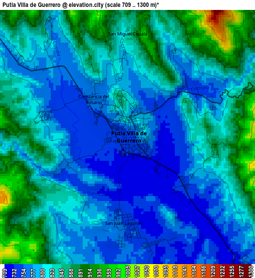
Below is the Elevation map of Putla Villa de Guerrero, which displays elevation range with different colors. Scale of the first map is from 709 to 1300 m (2326 to 4265 ft) with average elevation of 815.4 meters (=2675 ft) [note 1]
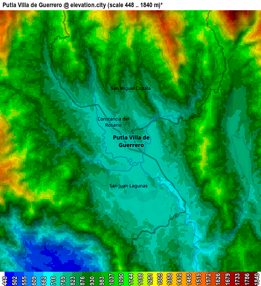
These maps also provides idea of topography and contour of this city, they are displayed at different zoom levels. More info about maps, scale and edge coordinates you can find below images.
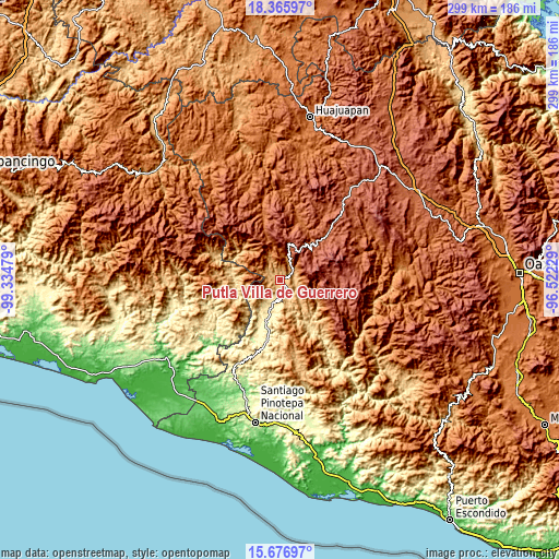
| \ | Map #1 | Map #2 | Topo.Map |
| Scale [m] | 709..1300 m | 448..1840 m | × |
| Scale [ft] | 2326..4265 ft | 1470..6037 ft | × |
| Average | 815.4 m = 2675 ft | 929.8 m = 3051 ft | × |
| Width | 9.34 km = 5.8 mi | 18.69 km = 11.6 mi | 299 km = 185.8 mi |
| Height | 9.34 km = 5.8 mi | 18.69 km = 11.6 mi | 299 km = 185.8 mi |
| ↑Max Latitude | 17.068314° | 17.11032° | 18.36597° |
| Latitude at center | 17.0263° | 17.0263° | 17.0263° |
| ↓Min Latitude | 16.984276° | 16.942243° | 15.67697° |
| ← Min Longitude | -97.972485° | -98.016431° | -99.33479° |
| Longitude center | -97.92854° | -97.92854° | -97.92854° |
| →Max Longitude | -97.884595° | -97.840649° | -96.52229° |
Nearby cities:
Cities around Putla Villa de Guerrero sort by population:
• Santa María Yucunicoco elevation 2454 m
23.5 km,  2°
2°
• San Juan Lagunas 754 m
3.2 km,  184°
184°
• La Soledad 815 m
28 km,  245°
245°
• San Martín Itunyoso 2612 m
23 km,  12°
12°
• Santa Cruz Yucucani 1381 m
20.4 km,  285°
285°
• Constancia del Rosario 763 m
1.9 km,  314°
314°
• San Andrés Chicahuaxtla 2448 m
17.5 km,  33°
33°
• San Sebastián Nopalera 1603 m
18.5 km,  120°
120°
• San Esteban Atatlahuca 2511 m
27 km,  80°
80°
• Santiago Nuyoó 1649 m
17.3 km,  94°
94°
• Santa Cruz Nundaco 2310 m
27.1 km,  53°
53°
• Santa María Yucuhiti 1736 m
16.9 km, 92°
Multilingual:
 En español:
Putla Villa de Guerrero elevación 747 m.
 En France:
Putla Villa de Guerrero élévation 747 m.
 Auf Deutsch:
Putla Villa de Guerrero höhe über dem Meeresspiegel ist 747 m.
 На русском:
Putla Villa de Guerrero высота над уровнем моря 747 м
Sources and notes:
- [note 1] Map square and city borders are not equal. Map elevation data is calculated only from area inside that square.
- [src 1] Elevation data from geonames database provided with same terms of usage.
- [src 2] The elevation map of Putla Villa de Guerrero is generated using elevation data from NASA's 3 arcsec (90m) resolution SRTM data.
- [src 3] Base (background) map © OpenStreetMap contributors tiles are generated by Geofabrik and OpenTopoMap.
Copyright & License:
This Putla Villa de Guerrero Elevation Map is licensed under CC BY-SA. You may reuse any part from this page, if you give a proper credit by linking to this URL:
 More info on terms of use page.