El Carmen elevation
El Carmen (Guerrero, Xochistlahuaca), Mexico elevation is 743 meters and El Carmen elevation in feet is 2438 ft above sea level [src 1]. El Carmen is a populated place (feature code) with elevation that is 571 meters (1873 ft) smaller than average city elevation in Mexico.
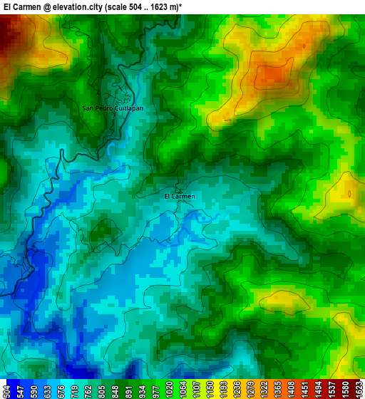
Below is the Elevation map of El Carmen, which displays elevation range with different colors. Scale of the first map is from 504 to 1623 m (1654 to 5325 ft) with average elevation of 880.6 meters (=2889 ft) [note 1]
These maps also provides idea of topography and contour of this city, they are displayed at different zoom levels. More info about maps, scale and edge coordinates you can find below images.
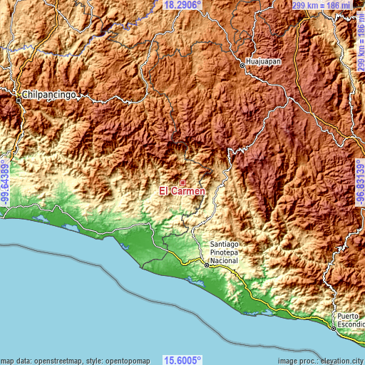
| \ | Map #1 | Topo.Map |
| Scale [m] | 504..1623 m | × |
| Scale [ft] | 1654..5325 ft | × |
| Average | 880.6 m = 2889 ft | × |
| Width | 9.35 km = 5.8 mi | 299.1 km = 185.9 mi |
| Height | 9.35 km = 5.8 mi | 299.1 km = 185.9 mi |
| ↑Max Latitude | 16.992392° | 18.2906° |
| Latitude at center | 16.95036° | 16.95036° |
| ↓Min Latitude | 16.908319° | 15.6005° |
| ← Min Longitude | -98.281585° | -99.64389° |
| Longitude center | -98.23764° | -98.23764° |
| →Max Longitude | -98.193695° | -96.83139° |
Nearby cities:
Cities around El Carmen sort by population:
• Tlacoachistlahuaca elevation 414 m
16.9 km,  203°
203°
• Xochistlahuaca 375 m
17.3 km,  181°
181°
• Guadalupe Victoria 456 m
22.4 km,  164°
164°
• Jicayán de Tovar 711 m
19.7 km,  0°
0°
• La Soledad 815 m
8.2 km,  114°
114°
• San Cristóbal 582 m
22.6 km,  230°
230°
• Colonia Renacimiento 478 m
21.7 km, 164°
• Santa Cruz Yucucani 1381 m
19.3 km,  43°
43°
• San Pedro Cuitlapan 766 m
2.9 km,  329°
329°
• Los Liros 301 m
23.5 km,  174°
174°
• El Jicaral 829 m
20 km,  12°
12°
• Rancho Viejo (Rancho Nuevo de la Democracia) 862 m
9.3 km, 9°
Multilingual:
 En español:
El Carmen elevación 743 m.
 En France:
El Carmen élévation 743 m.
 Auf Deutsch:
El Carmen höhe über dem Meeresspiegel ist 743 m.

Sources and notes:
- [note 1] Map square and city borders are not equal. Map elevation data is calculated only from area inside that square.
- [src 1] Elevation data from geonames database provided with same terms of usage.
- [src 2] The elevation map of El Carmen is generated using elevation data from NASA's 3 arcsec (90m) resolution SRTM data.
- [src 3] Base (background) map © OpenStreetMap contributors tiles are generated by Geofabrik and OpenTopoMap.
Copyright & License:
This El Carmen Elevation Map is licensed under CC BY-SA. You may reuse any part from this page, if you give a proper credit by linking to this URL:
 More info on terms of use page.