San Francisco Loxicha elevation
San Francisco Loxicha (Oaxaca, San Agustín Loxicha), Mexico elevation is 497 meters and San Francisco Loxicha elevation in feet is 1631 ft above sea level [src 1]. San Francisco Loxicha is a populated place (feature code) with elevation that is 817 meters (2680 ft) smaller than average city elevation in Mexico.
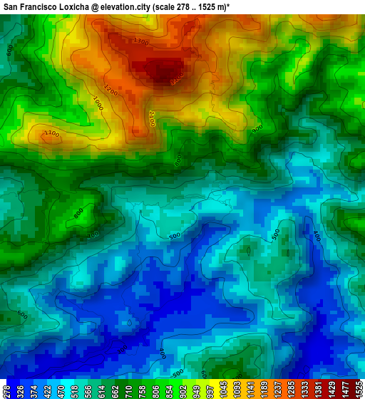
Below is the Elevation map of San Francisco Loxicha, which displays elevation range with different colors. Scale of the first map is from 278 to 1525 m (912 to 5003 ft) with average elevation of 681.2 meters (=2235 ft) [note 1]
These maps also provides idea of topography and contour of this city, they are displayed at different zoom levels. More info about maps, scale and edge coordinates you can find below images.
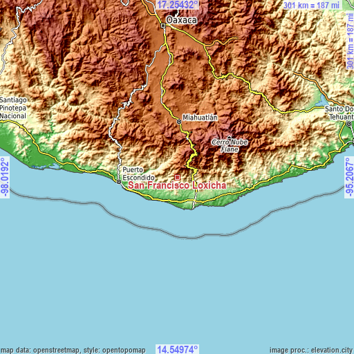
| \ | Map #1 | Topo.Map |
| Scale [m] | 278..1525 m | × |
| Scale [ft] | 912..5003 ft | × |
| Average | 681.2 m = 2235 ft | × |
| Width | 9.4 km = 5.8 mi | 300.7 km = 186.8 mi |
| Height | 9.4 km = 5.8 mi | 300.7 km = 186.8 mi |
| ↑Max Latitude | 15.948838° | 17.25432° |
| Latitude at center | 15.90658° | 15.90658° |
| ↓Min Latitude | 15.864313° | 14.54974° |
| ← Min Longitude | -96.656895° | -98.0192° |
| Longitude center | -96.61295° | -96.61295° |
| →Max Longitude | -96.569005° | -95.2067° |
Nearby cities:
Cities around San Francisco Loxicha sort by population:
• San Agustín Loxicha elevation 1836 m
12.3 km,  358°
358°
• San Francisco Cozoaltepec 142 m
15.7 km,  229°
229°
• Candelaria Loxicha 452 m
13 km,  80°
80°
• San José Chacalapa 231 m
18.1 km,  118°
118°
• Santa María Tonameca 40 m
19 km,  158°
158°
• Santo Domingo de Morelos 157 m
9.9 km,  215°
215°
• San Roque 199 m
20.8 km,  129°
129°
• San Bartolomé Loxícha 1211 m
12.5 km,  304°
304°
• Los Naranjos Esquipulas 1377 m
18.5 km,  63°
63°
• San José Piedras Negras 217 m
8.1 km, 163°
• El Camalote 329 m
4 km,  196°
196°
• Quelové 1290 m
11 km,  320°
320°
Multilingual:
 En español:
San Francisco Loxicha elevación 497 m.
 En France:
San Francisco Loxicha élévation 497 m.
 Auf Deutsch:
San Francisco Loxicha höhe über dem Meeresspiegel ist 497 m.
 На русском:
San Francisco Loxicha высота над уровнем моря 497 м
Sources and notes:
- [note 1] Map square and city borders are not equal. Map elevation data is calculated only from area inside that square.
- [src 1] Elevation data from geonames database provided with same terms of usage.
- [src 2] The elevation map of San Francisco Loxicha is generated using elevation data from NASA's 3 arcsec (90m) resolution SRTM data.
- [src 3] Base (background) map © OpenStreetMap contributors tiles are generated by Geofabrik and OpenTopoMap.
Copyright & License:
This San Francisco Loxicha Elevation Map is licensed under CC BY-SA. You may reuse any part from this page, if you give a proper credit by linking to this URL:
 More info on terms of use page.