Quelové elevation
Quelové (Oaxaca, San Agustín Loxicha), Mexico elevation is 1290 meters and Quelové elevation in feet is 4232 ft above sea level [src 1]. Quelové is a populated place (feature code) with elevation that is 24 meters (79 ft) smaller than average city elevation in Mexico.
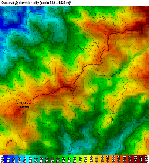
Below is the Elevation map of Quelové, which displays elevation range with different colors. Scale of the first map is from 342 to 1523 m (1122 to 4997 ft) with average elevation of 932.6 meters (=3060 ft) [note 1]
These maps also provides idea of topography and contour of this city, they are displayed at different zoom levels. More info about maps, scale and edge coordinates you can find below images.
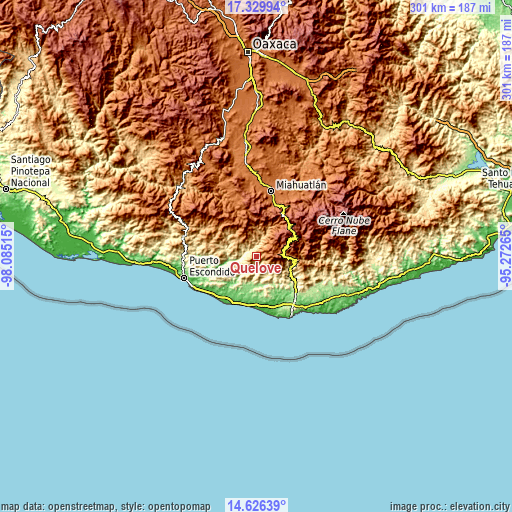
| \ | Map #1 | Topo.Map |
| Scale [m] | 342..1523 m | × |
| Scale [ft] | 1122..4997 ft | × |
| Average | 932.6 m = 3060 ft | × |
| Width | 9.39 km = 5.8 mi | 300.6 km = 186.8 mi |
| Height | 9.39 km = 5.8 mi | 300.6 km = 186.8 mi |
| ↑Max Latitude | 16.024972° | 17.32994° |
| Latitude at center | 15.98273° | 15.98273° |
| ↓Min Latitude | 15.940479° | 14.62639° |
| ← Min Longitude | -96.722845° | -98.08515° |
| Longitude center | -96.6789° | -96.6789° |
| →Max Longitude | -96.634955° | -95.27265° |
Nearby cities:
Cities around Quelové sort by population:
• Santa Catarina Loxicha elevation 1276 m
12.5 km,  319°
319°
• San Agustín Loxicha 1836 m
7.7 km,  60°
60°
• San Baltazar Loxicha 999 m
15.6 km,  312°
312°
• San Francisco Cozoaltepec 142 m
19.3 km,  194°
194°
• Candelaria Loxicha 452 m
20.9 km,  107°
107°
• Santo Domingo de Morelos 157 m
16.6 km,  175°
175°
• San Francisco Coatlán 1574 m
23.8 km,  338°
338°
• San Bartolomé Loxícha 1211 m
3.6 km,  246°
246°
• Los Naranjos Esquipulas 1377 m
23.5 km,  90°
90°
• San José Piedras Negras 217 m
18.7 km,  150°
150°
• El Camalote 329 m
13.6 km, 154°
• San Francisco Loxicha 497 m
11 km,  140°
140°
Multilingual:
 En español:
Quelové elevación 1290 m.
 En France:
Quelové élévation 1290 m.
 Auf Deutsch:
Quelové höhe über dem Meeresspiegel ist 1290 m.

Sources and notes:
- [note 1] Map square and city borders are not equal. Map elevation data is calculated only from area inside that square.
- [src 1] Elevation data from geonames database provided with same terms of usage.
- [src 2] The elevation map of Quelové is generated using elevation data from NASA's 3 arcsec (90m) resolution SRTM data.
- [src 3] Base (background) map © OpenStreetMap contributors tiles are generated by Geofabrik and OpenTopoMap.
Copyright & License:
This Quelové Elevation Map is licensed under CC BY-SA. You may reuse any part from this page, if you give a proper credit by linking to this URL:
 More info on terms of use page.